File:Map Iberian Peninsula 1000-bg.svg
(Redirected from File:Península ibérica 1000 bg.svg)

Size of this PNG preview of this SVG file: 800 × 555 pixels. Other resolutions: 320 × 222 pixels | 640 × 444 pixels | 1,024 × 711 pixels | 1,280 × 888 pixels | 2,560 × 1,777 pixels | 827 × 574 pixels.
Original file (SVG file, nominally 827 × 574 pixels, file size: 236 KB)
Captions
Captions
Add a one-line explanation of what this file represents
| Description |
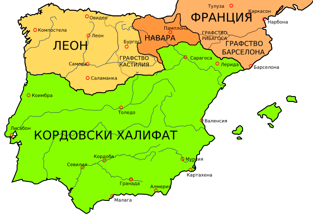
English: Map of the Iberian Peninsula in 1000. Español: Mapa de la peninsula ibérica en el año 1000. Русский: Карта Пиренейского полуострова в 1000 году. Български: Карта на Пиренейския полуостров през 1000 г. |
| Date | (UTC) |
| Source | |
| Author |
|
| Other versions |
[]
See also[edit] |


| This is a retouched picture, which means that it has been digitally altered from its original version. Modifications: translation. The original can be viewed here: Península ibérica 1000.svg:
|

|
This SVG file contains embedded text that can be translated into your language, using any capable SVG editor, text editor or the SVG Translate tool. For more information see: About translating SVG files. |
I, the copyright holder of this work, hereby publish it under the following licenses:
This file is licensed under the Creative Commons Attribution-Share Alike 3.0 Unported, 2.5 Generic, 2.0 Generic and 1.0 Generic license.
- You are free:
- to share – to copy, distribute and transmit the work
- to remix – to adapt the work
- Under the following conditions:
- attribution – You must give appropriate credit, provide a link to the license, and indicate if changes were made. You may do so in any reasonable manner, but not in any way that suggests the licensor endorses you or your use.
- share alike – If you remix, transform, or build upon the material, you must distribute your contributions under the same or compatible license as the original.

|
Permission is granted to copy, distribute and/or modify this document under the terms of the GNU Free Documentation License, Version 1.2 or any later version published by the Free Software Foundation; with no Invariant Sections, no Front-Cover Texts, and no Back-Cover Texts. A copy of the license is included in the section entitled GNU Free Documentation License. |
You may select the license of your choice.
Original upload log[edit]
This image is a derivative work of the following images:
- File:Península_ibérica_1000.svg licensed with Cc-by-sa-3.0,2.5,2.0,1.0, GFDL
- 2009-03-16T16:49:11Z Rastrojo 827x574 (241604 Bytes) Rivagorza -> Ribagorza
- 2009-01-19T22:47:37Z Phirosiberia 827x574 (239748 Bytes) {{Information |Description= |Source= |Date= |Author= |Permission= |other_versions= }}
- 2009-01-19T22:44:51Z Phirosiberia 827x574 (239747 Bytes) {{Information |Description={{en|1=Map of the Iberian Peninsula in 1000.}} {{es|1=Mapa de la peninsula ibérica en el año 1000.}} |Source=[[:File:España1000.jpg]], part of [http://www.lib.utexas.edu/maps/historical/shepherd_
Uploaded with derivativeFX
File history
Click on a date/time to view the file as it appeared at that time.
| Date/Time | Thumbnail | Dimensions | User | Comment | |
|---|---|---|---|---|---|
| current | 16:30, 12 April 2009 | | 827 × 574 (236 KB) | Nauka (talk | contribs) | {{Information |Description={{en|1=Map of the Iberian Peninsula in 1000.}} {{es|1=Mapa de la peninsula ibérica en el año 1000.}} {{ru|1=Карта Пиренейского полуострова в 1000 году.}} {{bg|1=Карта на Пиренейс |
You cannot overwrite this file.
File usage on Commons
The following 14 pages use this file:
- File:Iberian Peninsula 1000 bg.svg (file redirect)
- File:Kartenn Ledenez Iberia 1000-br.svg
- File:Map Iberian Peninsula 1000-be.svg
- File:Map Iberian Peninsula 1000-bg.svg
- File:Map Iberian Peninsula 1000-de.svg
- File:Map Iberian Peninsula 1000-es.svg
- File:Map Iberian Peninsula 1000-fr.svg
- File:Map Iberian Peninsula 1000-hu.svg
- File:Map Iberian Peninsula 1000-mn.svg
- File:Map Iberian Peninsula 1000-ru.svg
- File:Mapa de la Península Ibérica nel añu 1000.svg
- File:Peninsula ibèrica 1000 ca.svg
- File:Península ibérica 1000 bg.svg (file redirect)
- Template:Other versions/Map Iberian Peninsula 1000