File:Picnisar1.jpg

Original file (1,041 × 585 pixels, file size: 140 KB, MIME type: image/jpeg)
Captions
Captions
Summary[edit]
| Description |
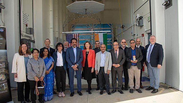
English: Officials from NASA, the Indian Space Research Organization (ISRO), and the Embassy of India hold a send-off ceremony for the NASA-ISRO Synthetic Aperture Radar (NISAR) science instrument payload on Feb. 3, 2023, outside a clean room at NASA's Jet Propulsion Laboratory in Southern California. The payload is scheduled to be shipped to India in March.
Pictured left to right: Karen St. Germain, director, Earth Science Division, NASA; Mitra Dutta, NISAR program executive, NASA; Sripriya Ranganathan, ambassador and deputy chief of mission, Indian Embassy; Larry James, deputy director, JPL; Bhavya Lal, associate administrator for technology, policy, and strategy, NASA; Jim Graf, director, Earth Science and Technology Directorate, JPL; S. Somanath, chairman, ISRO; Laurie Leshin, director, JPL; Krunal Joshi, counselor, space and ISRO technical liaison officer, Indian Embassy; M. Sankaran, director, U R Rao Satellite Centre, ISRO; Shantanu Bhatawdekar, scientific secretary, ISRO; Paul Rosen, NISAR project scientist, JPL; CV Shrikant, NISAR project director, ISRO; Phil Barela, NISAR project manager, JPL; and Gerald Bawden, NISAR program scientist, NASA. NISAR – a joint effort between NASA and ISRO – will measure changes to Earth's land ice surfaces down to fractions of an inch. Data collected by this satellite will help researchers monitor a wide range of changes critical to life on Earth in unprecedented detail. This includes spotting warning signs of imminent volcanic eruptions, helping to monitor groundwater supplies, tracking the melt rate of ice sheets tied to sea level rise, and observing shifts in the distribution of vegetation around the world. The data will inform humanity's responses to urgent challenges posed by natural disasters and climate change, and help communities prepare for and manage hazards. There are two instruments on the satellite that will send and receive radar signals to and from Earth's surface to make the mission's measurements. An L-band synthetic aperture radar (SAR), which uses a signal wavelength of around 9 inches (24 centimeters), and an S-band SAR with a signal wavelength of nearly 5 inches (12 centimeters). Both will bounce their microwave signal off of the planet's surface and record how long it takes the signal to make one roundtrip, as well as the strength of that return signal. This enables the researchers to calculate the distance from the spacecraft to Earth's surface and thereby determine how the land or ice is changing. An antenna reflector nearly 40 feet (12 meters) in diameter, supported by a deployable boom, will focus the microwave signals sent and received by the SARs. JPL, which is managed for NASA by Caltech in Pasadena, leads the U.S. component of NISAR and is providing the mission's L-band SAR instrument. NASA is also providing the radar reflector antenna, the deployable boom, a high-rate communication subsystem for science data, GPS receivers, a solid-state recorder, and payload data subsystem. ISRO is providing the spacecraft bus, the S-band SAR, the launch vehicle, and associated launch services and satellite mission operations. |
| Date | Taken on 3 February 2023 |
| Source | https://www.isro.gov.in/NISARSatellite.html; see also https://images.nasa.gov/details/PIA25600 and https://photojournal.jpl.nasa.gov/catalog/PIA25600 |
| Author | NASA/JPL-Caltech |
| Other versions |

This image or video was catalogued by Jet Propulsion Laboratory of the United States National Aeronautics and Space Administration (NASA) under Photo ID: PIA25600. This tag does not indicate the copyright status of the attached work. A normal copyright tag is still required. See Commons:Licensing. Other languages:
|
Licensing[edit]
| This file is in the public domain in the United States because it was solely created by NASA. NASA copyright policy states that "NASA material is not protected by copyright unless noted". (See Template:PD-USGov, NASA copyright policy page or JPL Image Use Policy.) | ||
 |
Warnings:
|
File history
Click on a date/time to view the file as it appeared at that time.
| Date/Time | Thumbnail | Dimensions | User | Comment | |
|---|---|---|---|---|---|
| current | 12:05, 16 February 2023 | | 1,041 × 585 (140 KB) | Chinakpradhan (talk | contribs) | Uploaded a work by NASA/JPL-Caltech from https://www.isro.gov.in/NISARSatellite.html with UploadWizard |
You cannot overwrite this file.
File usage on Commons
The following page uses this file: