File:Plan Troy-Hisarlik-da.svg
Jump to navigation
Jump to search

Size of this PNG preview of this SVG file: 664 × 599 pixels. Other resolutions: 266 × 240 pixels | 532 × 480 pixels | 851 × 768 pixels | 1,135 × 1,024 pixels | 2,270 × 2,048 pixels | 1,280 × 1,155 pixels.
Original file (SVG file, nominally 1,280 × 1,155 pixels, file size: 158 KB)
Captions
Captions
Add a one-line explanation of what this file represents
| Description |
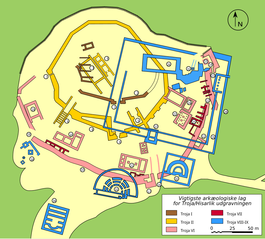
Dansk: Kort over den arkæologiske udgravning af Troja/Hisarlik.
Signaturforklaring:
|
||
| Date | (French original); 2007-09-21 (Danish translation) | ||
| Source | Own work. Data from http://www.goddess-athena.org/Museum/Temples/Troy/Troy_Plan.html and http://clubachille.free.fr/img_armees/troie_plan.jpg. | ||
| Author | Bibi Saint-Pol (French original); Sachse (Danish translation) | ||
| Permission (Reusing this file) |
|
||
| Other versions |
[]
|


|
This SVG file contains embedded text that can be translated into your language, using any capable SVG editor, text editor or the SVG Translate tool. For more information see: About translating SVG files. |
File history
Click on a date/time to view the file as it appeared at that time.
| Date/Time | Thumbnail | Dimensions | User | Comment | |
|---|---|---|---|---|---|
| current | 09:40, 21 September 2007 | | 1,280 × 1,155 (158 KB) | Sachse (talk | contribs) | {{Information |Description=English: Plan of the archeological site of Troy/Hisarlik. Legend: * 1: Port * 2: Bymur * 3: Megarons * 4: FN Port * 5: FO Port * 6: FM Port og rampe * 7: FJ Port * 8: Bymur * 9: Megarons |
You cannot overwrite this file.
File usage on Commons
The following 11 pages use this file:
- File:Plan Troy-Hisarlik-da.svg
- File:Plan Troy-Hisarlik-de.svg
- File:Plan Troy-Hisarlik-el.svg
- File:Plan Troy-Hisarlik-en.svg
- File:Plan Troy-Hisarlik-es.svg
- File:Plan Troy-Hisarlik-fr.svg
- File:Plan Troy-Hisarlik-hu.svg
- File:Plan Troy-Hisarlik-nl.svg
- File:Plan Troy-Hisarlik-ru.svg
- File:Plan Troy-Hisarlik-tr.svg
- Template:Other versions/Plan Troy-Hisarlik
File usage on other wikis
The following other wikis use this file: