File:Plan du jardin et chateau de la Reine.png
Jump to navigation
Jump to search

Size of this preview: 800 × 528 pixels. Other resolutions: 320 × 211 pixels | 640 × 422 pixels | 1,024 × 676 pixels | 1,280 × 845 pixels | 2,560 × 1,690 pixels | 11,833 × 7,811 pixels.
Original file (11,833 × 7,811 pixels, file size: 549.13 MB, MIME type: image/png)
Captions
Captions
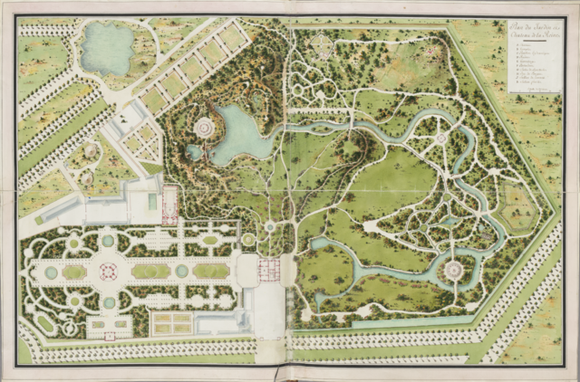
Plan of the Queen's garden and castle
Summary[edit]
| Warning | The original file is very high-resolution. It might not load properly or could cause your browser to freeze when opened at full size. |
|---|
| Description |
Svenska: Ingår i en bunden volym med en planritning över området Trianon och sammanlagt fyra målningar av delar av trädgården med templet, paviljongen och ruinen vid Petit Trianon, Versailles. Français : Plan du jardin et château de la Reine, Versailles, France.
English: Plan of the Petit Trianon and the surrounding park, part of the gardens of Versailles, France. |
||
| Date | between 1770 and 1795 | ||
| Source |
|
||
| Creator | |||
| Georeferencing | If inappropriate please set warp_status = skip to hide. | ||
| Other versions |
|


|
This image was selected as picture of the day on Wikimedia Commons for 15 July 2014. It was captioned as follows: English: Map over Petit Trianon and the surrounding park, part of the gardens of Versailles. Other languages:
Bosanski: Karta dvorca Petit Trianon i okolnih parkova, dio vrtova Versaillesa. Čeština: Mapa zobrazující zámek Malý Trianon a okolní park, součást zahrad ve Versailles nedaleko Paříže. English: Map over Petit Trianon and the surrounding park, part of the gardens of Versailles. Français : Carte du Petit Trianon et des parcs qui l'entourrent, château de Versailles, France. Italiano: Mappa del Petit Trianon e del parco circostante nei giardini della Reggia di Versailles in Francia. Nederlands: Kaart met Klein Trianon en het omliggende park die onderdeel zijn van de tuinen van Versailles. 한국어: 베르사이유의 정원의 일부인 쁘띠 트리아농과 주변 공원의 지도. 中文: 法国凡尔赛小特里亚农宫和周围公园的地图。 中文(繁體): 法國小特里亞農宮以及周圍公園的地圖,屬於凡爾賽花園的一部分。 |
| Camera location | | View this and other nearby images on: OpenStreetMap |
|---|
Caption top right:
Plan du Jardin et Chateau de la Reine
A Chateau.
B Temple.
C Pavillon hydraulique.
D Ruine.
E Hermitage.
F Belvedere.
G Salle de spectacle.
H Jeu de Bague.
J Sallon de concert.
K Sallon frais.
Echelle de 25 toises.
A Chateau.
B Temple.
C Pavillon hydraulique.
D Ruine.
E Hermitage.
F Belvedere.
G Salle de spectacle.
H Jeu de Bague.
J Sallon de concert.
K Sallon frais.
Echelle de 25 toises.
Licensing[edit]
Scan from the original work
Physical object
| |||||||
| Annotations | This image is annotated: View the annotations at Commons |
File history
Click on a date/time to view the file as it appeared at that time.
| Date/Time | Thumbnail | Dimensions | User | Comment | |
|---|---|---|---|---|---|
| current | 20:08, 17 December 2013 | | 11,833 × 7,811 (549.13 MB) | Kungbib (talk | contribs) | User created page with UploadWizard |
| 20:08, 17 December 2013 |  | 11,833 × 7,811 (549.13 MB) | Kungbib (talk | contribs) | User created page with UploadWizard |
You cannot overwrite this file.
File usage on Commons
The following 34 pages use this file:
- User:Beria/POTY per date
- User:Miya/POTY/2014
- User:Ö/Best/2014
- User talk:ArildV/Archive 2014
- Commons:Featured picture candidates/File:Plan du jardin et chateau de la Reine.png
- Commons:Featured picture candidates/Log/February 2014
- Commons:Featured pictures/Non-photographic media/Maps
- Commons:Featured pictures/chronological/2014-A
- Commons:Kungliga biblioteket/Reports
- Commons:Kungliga biblioteket/Reports/most edited
- Commons:Kungliga biblioteket/Reports/wikimedia usage
- Commons:Picture of the Year/2014/Candidates
- Commons:Picture of the Year/2014/R1/Gallery/2014-A
- Commons:Picture of the Year/2014/R1/Gallery/ALL
- Commons:Picture of the Year/2014/R1/Gallery/M02
- Commons:Picture of the Year/2014/R1/Gallery/Maps
- Commons:Picture of the Year/2014/R1/Results/Candidates
- Commons:Picture of the Year/2014/R1/Results/Candidates/Maps and diagrams
- Commons:Picture of the Year/2014/R1/Results/Maps and diagrams
- Commons:Picture of the Year/2014/R1/v/Plan du jardin et chateau de la Reine.png
- Template:Potd/2014-07
- Template:Potd/2014-07-15
- Template:Potd/2014-07-15 (bs)
- Template:Potd/2014-07-15 (cs)
- Template:Potd/2014-07-15 (en)
- Template:Potd/2014-07-15 (fr)
- Template:Potd/2014-07-15 (hu)
- Template:Potd/2014-07-15 (it)
- Template:Potd/2014-07-15 (ko)
- Template:Potd/2014-07-15 (lv)
- Template:Potd/2014-07-15 (nl)
- Template:Potd/2014-07-15 (zh-hans)
- Template:Potd/2014-07-15 (zh-hant)
- Template:Potd/2014-07 (zh-hans)
File usage on other wikis
The following other wikis use this file:
- Usage on be-tarask.wikipedia.org
- Usage on bn.wikipedia.org
- Usage on ca.wikipedia.org
- Usage on ceb.wikipedia.org
- Usage on crh.wikipedia.org
- Usage on cv.wikipedia.org
- Usage on de.wikipedia.org
- Usage on en.wikipedia.org
- Usage on et.wikipedia.org
- Usage on fr.wikipedia.org
- Usage on hu.wikipedia.org
- Usage on it.wikipedia.org
- Usage on ka.wikipedia.org
- Usage on ko.wikipedia.org
- Usage on krc.wikipedia.org
- Usage on lbe.wikipedia.org
- Usage on mg.wikipedia.org
- Usage on nl.wikipedia.org
- Usage on nn.wikipedia.org
- Usage on os.wikipedia.org
- Usage on pt.wikipedia.org
- Usage on ru.wikipedia.org
- Usage on ru.wikinews.org
- Usage on sah.wikipedia.org
- Usage on sv.wikipedia.org
- Usage on tt.wikipedia.org
- Usage on uk.wikipedia.org
- Usage on xal.wikipedia.org
- Usage on zh.wikipedia.org