File:Pleurobranchus areolatus map.png

Original file (1,396 × 865 pixels, file size: 3.22 MB, MIME type: image/png)
Captions
Captions
| Description |
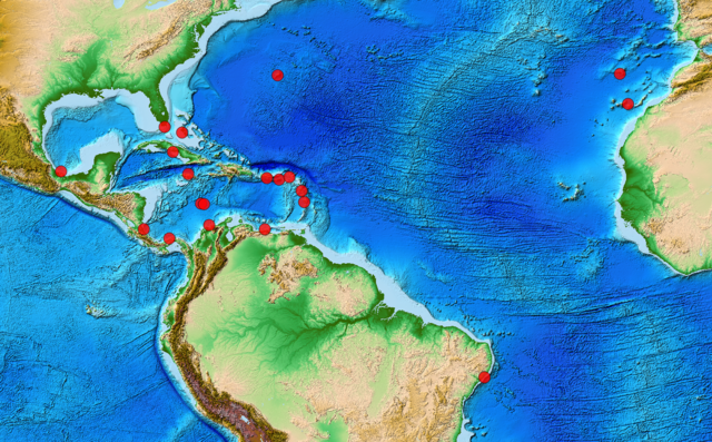
English: Distribution map of Pleurobranchus areolatus.
Coordinates are only approximate. Layer: ETOPO1 Global Relief Model. |
| Date | |
| Source |
18.854669	 -95.132935
25.067128	 -80.621263
32.239465	 -64.796274
28.254530	 -15.776998
32.488812	 -16.957811
21.523130	 -79.447678
18.490206	 -77.328392
24.287492	 -78.171888
10.786494	 -83.549160
9.500441	 -79.995475
11.337484	 -74.373254
14.336546	 -75.522993
14.261267	 -75.087957
10.732080	 -66.617618
17.880692	 -66.353946
17.713323	 -64.623351
16.123747	 -61.494276
14.566387	 -61.098768
18.063994	 -63.168227
-9.929031	 -35.866341
Range data are manually and approximately estimated from the Figure 2 by Alvim J. & Pimenta A. D. (2016).[1]
|
| Author | User:Snek01 |
| Permission (Reusing this file) |
Permission for raster map data:
|
| I, the copyright holder of this work, release this work into the public domain. This applies worldwide. In some countries this may not be legally possible; if so: I grant anyone the right to use this work for any purpose, without any conditions, unless such conditions are required by law. |
This image is in the public domain because it contains materials that originally came from the U.S. National Oceanic and Atmospheric Administration, taken or made as part of an employee's official duties.
|
File history
Click on a date/time to view the file as it appeared at that time.
| Date/Time | Thumbnail | Dimensions | User | Comment | |
|---|---|---|---|---|---|
| current | 22:42, 21 October 2016 | | 1,396 × 865 (3.22 MB) | Snek01 (talk | contribs) | {{Information |Description={{en|Distribution map of ''Pleurobranchus areolatus''. Coordinates are only approximate. Layer: ETOPO1 Global Relief Model. }} |Source= * {{own}} Created by Michal Maňas in QGIS. * Range data: 18.854669 -95.... |
You cannot overwrite this file.
File usage on Commons
There are no pages that use this file.
File usage on other wikis
The following other wikis use this file:
- Usage on en.wikipedia.org