File:Qom County-2016 & 2017-Photographer Mostafa Meraji-Copyleft photos from Iran-Canon Photography 11.jpg
Jump to navigation
Jump to search

Size of this preview: 800 × 533 pixels. Other resolutions: 320 × 213 pixels | 640 × 427 pixels | 1,024 × 683 pixels | 1,280 × 853 pixels | 2,560 × 1,707 pixels | 5,472 × 3,648 pixels.
Original file (5,472 × 3,648 pixels, file size: 9.39 MB, MIME type: image/jpeg)
Captions
Captions
Add a one-line explanation of what this file represents
Summary[edit]
| Description |
فارسی: شهرستان قم یکی از شهرستانهای استان قم در مرکز ایران است؛ مرکز این شهرستان شهر قم است.
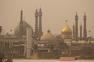
English: Qom County is located in Qom province, Iran. The capital of the county is Qom. At the 2006 census, the county's population (including those portions of the county later split off to form Jafarabad County and Kahak County) was 1,036,714, in 262,313 households.
العربية: مقاطعة قم مقاطعة إيرانية في محافظة قم.
Deutsch: Ghom bzw. Qom ist ein Schahrestan in der Provinz Ghom im Iran. Er enthält die Stadt Ghom, welche die Hauptstadt des Verwaltungsbezirks ist. Der Verwaltungsbezirk bildet den einzigen Verwaltungsbezirk der Provinz Ghom und ist mit dieser deckungsgleich.
Italiano: Lo shahrestān di Qom è l'unico shahrestān della provincia di Qom, con cui quindi coincide territorialmente.
हिन्दी: क़ोम शहरेस्तन एक शहरेस्तान हैं क़ोम प्रांत, ईरान मैं।
Türkçe: Kum şehristanı, İran'nde Kum Eyaleti'ne bağlı olan tek şehristandır.
کوردی: شارستانی قوم تەنیا شارستانی پارێزگای قومی ئێرانە. ناوەندی ئەم شارستانە شاری قومە.
Norsk nynorsk: Qom fylke er det einaste fylket i Qom-provinsen i Iran, som dekkjer det same området. Det administrative senteret i fylket er Qom.
日本語: ゴム郡 は、イラン、ゴム州に属する郡。2006年には、262,313世帯・ 1,036,714人が居住していた。この郡にはJafarabad、Khalajastan、the Central、Kahak、 Salafcheganの5つの地方行政区がある。
Azərbaycanca: Qum şəhristanı — İranın Qum ostanında bölgə, inzibati mərkəzi Qum şəhəridir. 2006-cı il əhalinin siyahıya alınmasına əsasən, şəhristanın əhalisi 1,036,714 nəfər və 262,313 ailədən ibarət idi. |
| Date | |
| Source | Own work |
| Author | Mostafameraji |
| Camera location | | View this and other nearby images on: OpenStreetMap |
|---|
Licensing[edit]
I, the copyright holder of this work, hereby publish it under the following license:
This file is licensed under the Creative Commons Attribution-Share Alike 4.0 International license.
- You are free:
- to share – to copy, distribute and transmit the work
- to remix – to adapt the work
- Under the following conditions:
- attribution – You must give appropriate credit, provide a link to the license, and indicate if changes were made. You may do so in any reasonable manner, but not in any way that suggests the licensor endorses you or your use.
- share alike – If you remix, transform, or build upon the material, you must distribute your contributions under the same or compatible license as the original.
File history
Click on a date/time to view the file as it appeared at that time.
| Date/Time | Thumbnail | Dimensions | User | Comment | |
|---|---|---|---|---|---|
| current | 11:17, 10 January 2023 | | 5,472 × 3,648 (9.39 MB) | Mostafameraji (talk | contribs) | Uploaded own work with UploadWizard |
You cannot overwrite this file.
File usage on Commons
There are no pages that use this file.
File usage on other wikis
The following other wikis use this file:
- Usage on fa.wikipedia.org