File:Quttinirpaaq National Park map-ru.svg
Jump to navigation
Jump to search

Size of this PNG preview of this SVG file: 800 × 582 pixels. Other resolutions: 320 × 233 pixels | 640 × 466 pixels | 1,024 × 745 pixels | 1,280 × 932 pixels | 2,560 × 1,863 pixels | 1,800 × 1,310 pixels.
Original file (SVG file, nominally 1,800 × 1,310 pixels, file size: 852 KB)
Captions
Captions
Add a one-line explanation of what this file represents
Summary[edit]
| Camera location | | View this and other nearby images on: OpenStreetMap |
|---|
| Description |
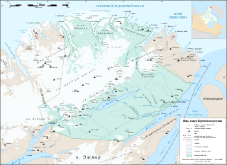
Русский: Карта национального парка Куттинирпаак (Нунавут, Канада
|
||
| Date | |||
| Source |
Own work |
||
| Author | Eric Gaba (Sting - fr:Sting), translated in Russian by Koryakov Yuri | ||
| Permission (Reusing this file) |
|
||
| Other versions |
|


|
This SVG file contains embedded text that can be translated into your language, using any capable SVG editor, text editor or the SVG Translate tool. For more information see: About translating SVG files. |
Licensing[edit]
I, the copyright holder of this work, hereby publish it under the following license:
This file is licensed under the Creative Commons Attribution-Share Alike 3.0 Unported license.
- You are free:
- to share – to copy, distribute and transmit the work
- to remix – to adapt the work
- Under the following conditions:
- attribution – You must give appropriate credit, provide a link to the license, and indicate if changes were made. You may do so in any reasonable manner, but not in any way that suggests the licensor endorses you or your use.
- share alike – If you remix, transform, or build upon the material, you must distribute your contributions under the same or compatible license as the original.
File history
Click on a date/time to view the file as it appeared at that time.
| Date/Time | Thumbnail | Dimensions | User | Comment | |
|---|---|---|---|---|---|
| current | 16:32, 19 October 2010 | | 1,800 × 1,310 (852 KB) | Koryakov Yuri (talk | contribs) | {{Information |Description={{en|1=Map of Quttinirpaaq National Park, Nunavut, Canada.}} |Source={{own}} |Author=Koryakov Yuri |Date=2010-10-19 |Permission= |other_versions= }} |
You cannot overwrite this file.
File usage on Commons
The following page uses this file:
File usage on other wikis
The following other wikis use this file:
- Usage on ru.wikipedia.org
- Usage on uk.wikipedia.org
- Usage on www.wikidata.org