File:Rogue Wild and Scenic River -- Recreation Section (25145265148).jpg
Original file (3,450 × 4,650 pixels, file size: 1.98 MB, MIME type: image/jpeg)
Captions
Captions
Summary[edit]
.jpg&action=edit§ion=1)
| Description |
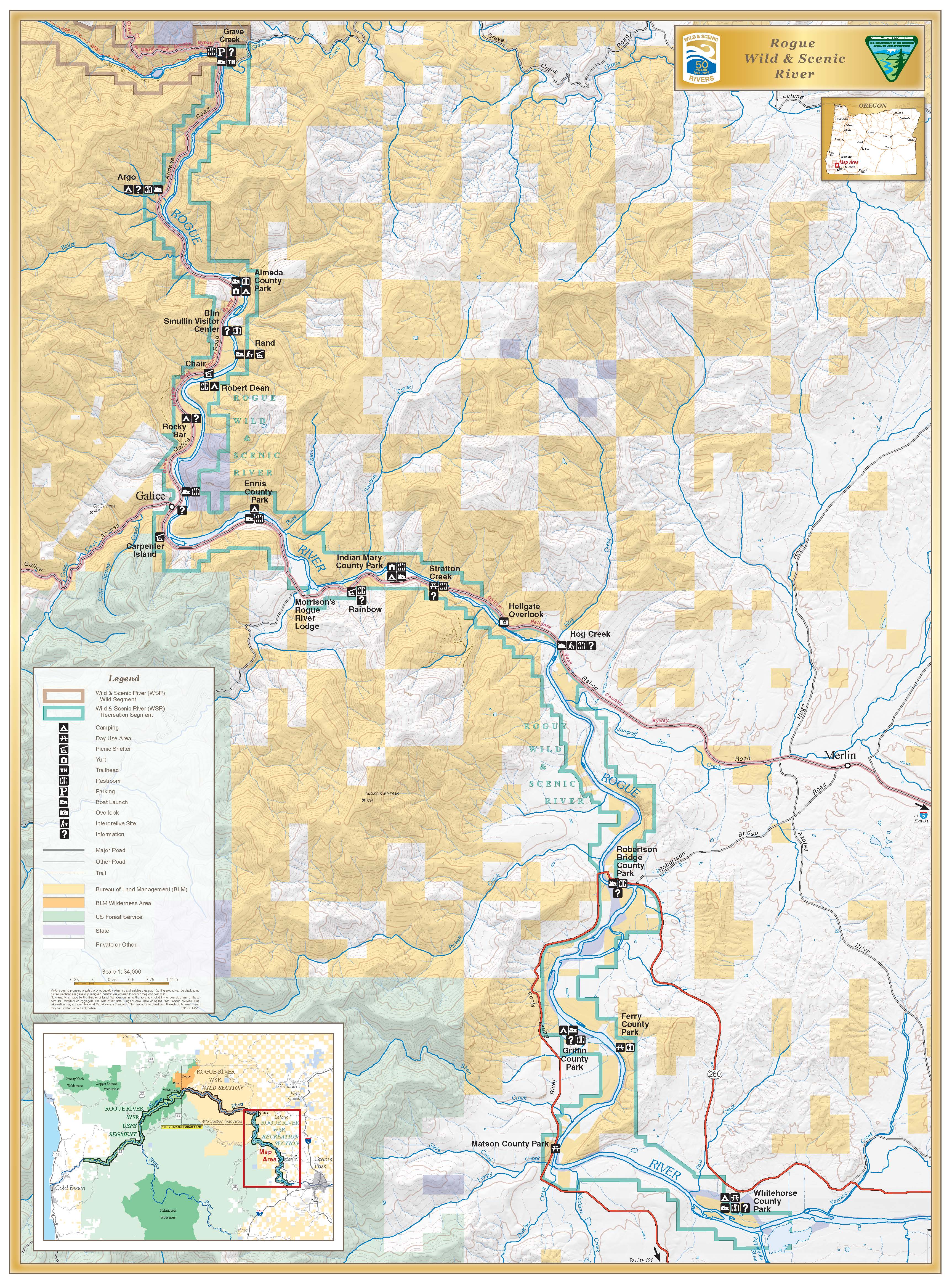
From its source in the high Cascade Mountains in southwestern Oregon near Crater Lake National Park, the Rogue, one of the longest rivers in Oregon, tumbles and flows more than 200 miles, entering the Pacific Ocean at Gold Beach. One of the eight rivers established with passage of the Wild and Scenic Rivers Act in 1968, the designated segment of the Rogue extends from the mouth of the Applegate River (about six miles downstream from Grants Pass) to the Lobster Creek Bridge (about eleven miles upstream from its mouth), a total distance of 84 miles. The first 47 miles are administered by the Medford District BLM, and the remaining 37 miles are administered by the Siskiyou National Forest. The Rogue River is known nationally for its salmon and steelhead fishing and high-quality whitewater boating opportunities. The lure of gold in the 1850s attracted a numbers of miners, hunters, stocker raisers and subsistence farmers. Conflicts between white settlers and Native Americans culminated in the 1855-56 Rogue River "Indian War," after which Native Americans relocated to reservations. For settlers, life in the Rogue Canyon was difficult and isolated. While gold mining operations were extensive, overall production was low. The remnants of mining, such as pipe, flumes, trestles and stamp mills can still be found. Designated Reach: October 2, 1968. The segment of the river extending from the mouth of the Applegate River downstream to the Lobster Creek Bridge. Classification/Mileage: Wild — 33.6 miles; Scenic — 7.5 miles; Recreational — 43.4 miles; Total — 84.5 miles. Outstandingly Remarkable Values Fisheries The Rogue River is home to a variety of species, including chinook salmon, coho salmon, steelhead, cutthroat trout and green sturgeon. The adult fish use the clean river substrate to deposit their eggs. The eggs then remain in the gravel for several months. After hatching, some species such as coho, steelhead and green sturgeon, rear within the river from one to three years, while others such as chinook begin the journey to the ocean and will eventually make their way back to their natal stream to spawn. It is not uncommon to see black bears, deer, otters, great blue herons and ospreys looking for a meal of salmon. Recreational The Rogue River area sees over a half million visitors each year. Recreation opportunities include driving for pleasure, boating, fishing, guided motorized tour boat trips, guided whitewater fishing and float trips, camping, hiking, swimming, picnicking, wildlife viewing, sun bathing and gold panning. Scenic Surrounding the Rogue River, the rugged and complex canyon landscape of the Wild Rogue Wilderness was partly designed to provide watershed protection for the wild section of the Rogue River. The established boundary assured preservation of a rugged and complex canyon landscape. The area is characterized by steep terrain of near vertical cliffs, razor-sharp ridges and cascading mountain creeks. Look for diverse flora and fauna among the near-vertical cliffs, razor-sharp ridges and cascading waters of numerous mountain creeks of the Rogue River watershed. For more information stop on by the BLM’s Medford District Office or contact: Phone: (541) 618-2200 E-mail: BLM_OR_MD_Mail@blm.gov www.blm.gov/visit |
| Date | |
| Source | Rogue Wild and Scenic River -- Recreation Section |
| Author | Bureau of Land Management Oregon and Washington from Portland, America |
Licensing[edit]
.jpg&action=edit§ion=2)
- You are free:
- to share – to copy, distribute and transmit the work
- to remix – to adapt the work
- Under the following conditions:
- attribution – You must give appropriate credit, provide a link to the license, and indicate if changes were made. You may do so in any reasonable manner, but not in any way that suggests the licensor endorses you or your use.
| This image was originally posted to Flickr by BLMOregon at https://flickr.com/photos/50169152@N06/25145265148 (archive). It was reviewed on 2 March 2018 by FlickreviewR 2 and was confirmed to be licensed under the terms of the cc-by-2.0. |
| This image is a work of a Bureau of Land Management* employee, taken or made as part of that person's official duties. As a work of the U.S. federal government, the image is in the public domain in the United States. *or predecessor organization |
File history
Click on a date/time to view the file as it appeared at that time.
| Date/Time | Thumbnail | Dimensions | User | Comment | |
|---|---|---|---|---|---|
| current | 09:10, 2 March 2018 | | 3,450 × 4,650 (1.98 MB) | Animalparty (talk | contribs) | Transferred from Flickr via Flickr2Commons |
You cannot overwrite this file.
File usage on Commons
There are no pages that use this file.
.jpg&oldid=791067551)