File:Rotterdam as seen by Envisat ESA226543.jpg
Jump to navigation
Jump to search

Size of this preview: 600 × 600 pixels. Other resolutions: 240 × 240 pixels | 480 × 480 pixels | 768 × 768 pixels | 1,024 × 1,024 pixels | 2,126 × 2,126 pixels.
Original file (2,126 × 2,126 pixels, file size: 2.11 MB, MIME type: image/jpeg)
Captions
Captions
Add a one-line explanation of what this file represents
Summary
[edit]| Description |
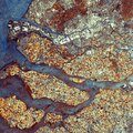
English: Envisat image of Rotterdam and the province of Zeeland, both located in the southwest of the Netherlands, acquired by the Advanced Synthetic Aperture Radar (ASAR) instrument in Image mode with a resolution of 12.5 m.
Rotterdam, the country’s second largest city after Amsterdam, is located on the New Meuse River, formed by the Rhine and Meuse rivers, that divides the municipality into its northern and southern parts. The city centre is situated on the northern bank (visible in light green). Rotterdam port (visible on left a quarter of the way down from top) is the largest port in Europe and the gateway to some 450 million consumers. The third body of land (lower left hand corner) is part of the province of Zeeland, a large river delta that mostly lies below sea level. |
| Date | |
| Source | http://www.esa.int/spaceinimages/Images/2007/08/Rotterdam_as_seen_by_Envisat |
| Author | European Space Agency |
| Permission (Reusing this file) |
ESA,CC BY-SA 3.0 IGO |
| Other versions |
|
| Title | Rotterdam as seen by Envisat |
| Keywords | Land use; Water (fresh); Rivers |
| Set | Earth observation image of the week |
| Mission | Envisat |
| Activity | Observing the Earth |
Licensing
[edit]
This file is licensed under the Creative Commons Attribution-ShareAlike 3.0 IGO license.
Attribution: ESA
- You are free:
- to share – to copy, distribute and transmit the work
- to remix – to adapt the work
- Under the following conditions:
- attribution – You must give appropriate credit, provide a link to the license, and indicate if changes were made. You may do so in any reasonable manner, but not in any way that suggests the licensor endorses you or your use.
- share alike – If you remix, transform, or build upon the material, you must distribute your contributions under the same or compatible license as the original.
File history
Click on a date/time to view the file as it appeared at that time.
| Date/Time | Thumbnail | Dimensions | User | Comment | |
|---|---|---|---|---|---|
| current | 18:34, 24 May 2017 | | 2,126 × 2,126 (2.11 MB) | Fæ (talk | contribs) | European Space Agency, Id 226543, http://www.esa.int/spaceinimages/Images/2007/08/Rotterdam_as_seen_by_Envisat, User:Fæ/Project_list/ESA |
You cannot overwrite this file.
File usage on Commons
The following page uses this file: