File:S-Bahn-Zuerich-Linienplan ab Ende 2015.svg
Jump to navigation
Jump to search

Size of this PNG preview of this SVG file: 681 × 600 pixels. Other resolutions: 273 × 240 pixels | 545 × 480 pixels | 872 × 768 pixels | 1,163 × 1,024 pixels | 2,325 × 2,048 pixels | 948 × 835 pixels.
Original file (SVG file, nominally 948 × 835 pixels, file size: 411 KB)
Captions
Captions
Add a one-line explanation of what this file represents
Summary[edit]
| Description |
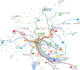
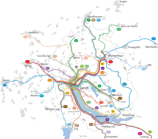
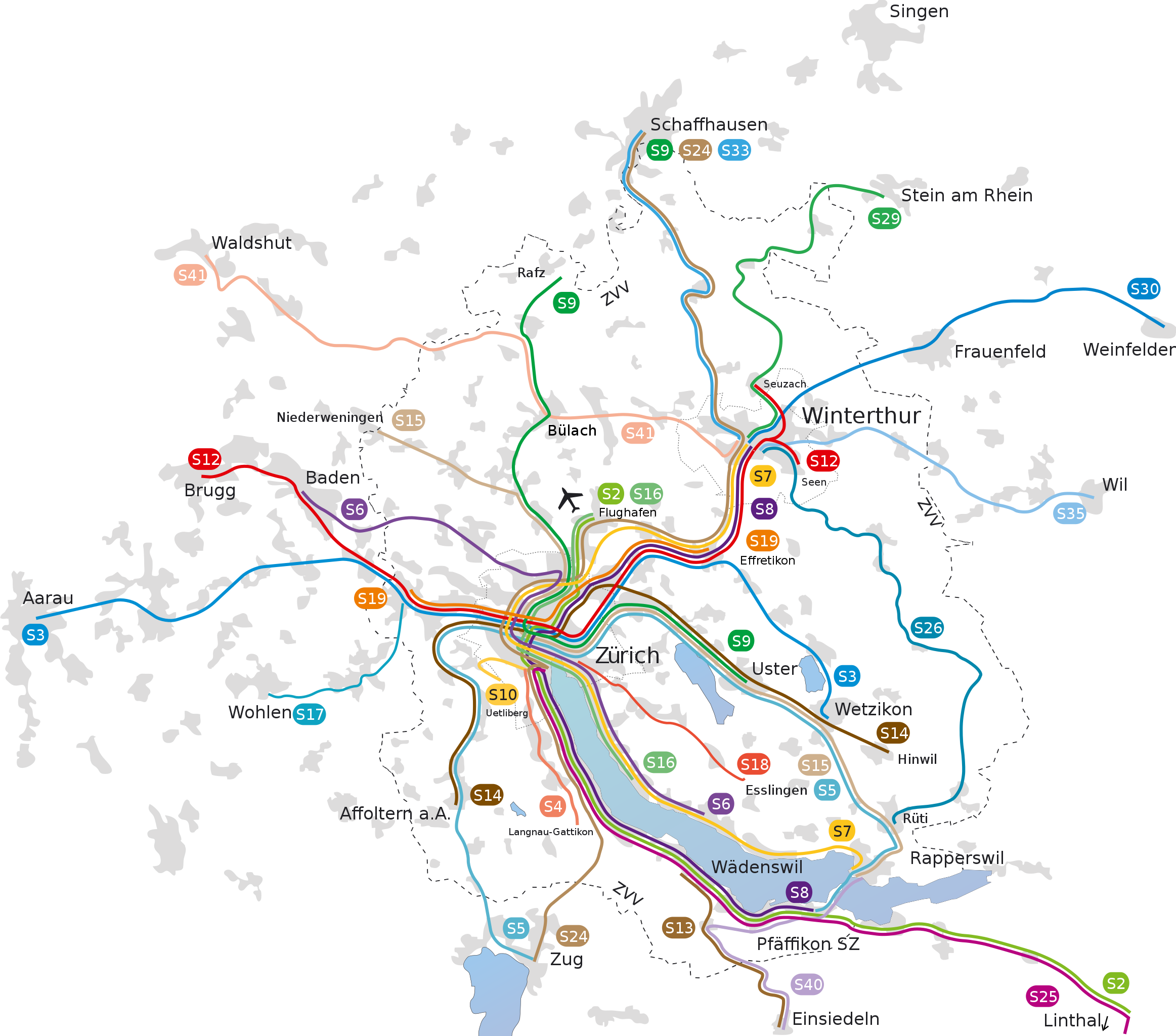
English: Unofficial map of Zurich S-Bahn as it stood after December 2015
Deutsch: Liniennetz der S-Bahn Zürich |
| Date | |
| Source |
|
| Author |
|
| Other versions |
|
Licensing[edit]
I, the copyright holder of this work, hereby publish it under the following licenses:

|
Permission is granted to copy, distribute and/or modify this document under the terms of the GNU Free Documentation License, Version 1.2 or any later version published by the Free Software Foundation; with no Invariant Sections, no Front-Cover Texts, and no Back-Cover Texts. A copy of the license is included in the section entitled GNU Free Documentation License. |
This file is licensed under the Creative Commons Attribution 3.0 Unported license.
- You are free:
- to share – to copy, distribute and transmit the work
- to remix – to adapt the work
- Under the following conditions:
- attribution – You must give appropriate credit, provide a link to the license, and indicate if changes were made. You may do so in any reasonable manner, but not in any way that suggests the licensor endorses you or your use.
You may select the license of your choice.
File history
Click on a date/time to view the file as it appeared at that time.
| Date/Time | Thumbnail | Dimensions | User | Comment | |
|---|---|---|---|---|---|
| current | 12:19, 22 August 2020 | | 948 × 835 (411 KB) | Spucky123r (talk | contribs) | Reverted to version as of 18:18, 6 January 2016 (UTC) |
| 09:38, 22 August 2020 |  | 936 × 784 (543 KB) | Spucky123r (talk | contribs) | Auf Fahrplanwechsel 2019 aktualisiert | |
| 18:18, 6 January 2016 |  | 948 × 835 (411 KB) | Kopiersperre (talk | contribs) | überbleibsel gelöscht | |
| 11:57, 2 January 2016 |  | 948 × 835 (466 KB) | Pechristener (talk | contribs) | == {{int:filedesc}} == {{Information |Description = {{en|Unofficial map of Zurich S-Bahn as it stood after December 2015}} {{de|Liniennetz der S-Bahn Zürich}} |Source= * S-Bahn-Zuerich-Linienplan.svg * ZVV Netzp... |
You cannot overwrite this file.
File usage on Commons
The following 6 pages use this file:
- User:Chumwa/OgreBot/Public transport information/2016 January 1-10
- User:Chumwa/OgreBot/Public transport information/2020 August 21-31
- User:Chumwa/OgreBot/Transport Maps/2016 January 1-10
- User:Chumwa/OgreBot/Transport Maps/2020 August 21-31
- User:Pingelig/Recent uploads/Canton of Thurgau/2016 January 1-10
- User:Pingelig/Recent uploads/Canton of Thurgau/2020 August 21-31
File usage on other wikis
The following other wikis use this file:
- Usage on als.wikipedia.org
- Usage on de.wikipedia.org
- Usage on es.wikipedia.org
- Usage on fr.wikipedia.org
- Usage on it.wikipedia.org
- Usage on ko.wikipedia.org
- Usage on pl.wikipedia.org
- Usage on sv.wikipedia.org
- Usage on th.wikipedia.org