File:SNB Wettingen-Winterthur.png
Jump to navigation
Jump to search
Size of this preview: 800 × 430 pixels. Other resolutions: 320 × 172 pixels | 640 × 344 pixels | 1,024 × 551 pixels | 1,280 × 688 pixels | 2,198 × 1,182 pixels.
Original file (2,198 × 1,182 pixels, file size: 2.83 MB, MIME type: image/png)
Captions
Captions
Add a one-line explanation of what this file represents
Summary[edit]
| Description |
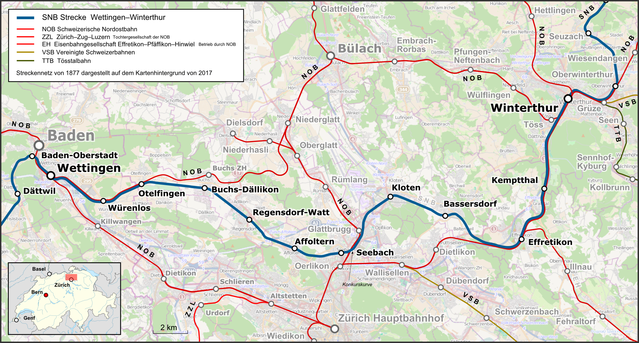
Deutsch: Karte der Strecke Wettingen—Winterthur der Schweizerischen Nationalbahn dargestellt im Eisenbahnnetz von 1877. |
| Date | |
| Source |
Map was created using:
|
| Author |
|
_location_map.svg)
Licensing[edit]
| This work is licensed under the Open Database License (summary). |
This file is licensed under the Creative Commons Attribution-Share Alike 2.0 Generic license.
Attribution: Peter Christener
- You are free:
- to share – to copy, distribute and transmit the work
- to remix – to adapt the work
- Under the following conditions:
- attribution – You must give appropriate credit, provide a link to the license, and indicate if changes were made. You may do so in any reasonable manner, but not in any way that suggests the licensor endorses you or your use.
- share alike – If you remix, transform, or build upon the material, you must distribute your contributions under the same or compatible license as the original.
File history
Click on a date/time to view the file as it appeared at that time.
| Date/Time | Thumbnail | Dimensions | User | Comment | |
|---|---|---|---|---|---|
| current | 19:36, 9 October 2017 | | 2,198 × 1,182 (2.83 MB) | Pechristener (talk | contribs) | korr Bahnhöfe |
| 19:03, 9 October 2017 |  | 2,198 × 1,182 (2.83 MB) | Pechristener (talk | contribs) | corrections on stations | |
| 08:20, 9 October 2017 |  | 2,198 × 1,182 (2.83 MB) | Pechristener (talk | contribs) | correction of stations and networ. Statement about 1877 network added. | |
| 15:27, 8 October 2017 |  | 2,198 × 1,182 (2.84 MB) | Pechristener (talk | contribs) | {{Information |Description={{de|1=Karte der Strecke Wettingen—Winterthur der {{w|Schweizerische Nationalbahn|Schweizerischen Nationalbahn|de}} dargestellt im Eisenbahnnetz von 1877.}} |Source=Map was created using: *[http://www.openstreetmap.org/ O... |
You cannot overwrite this file.
File usage on Commons
The following 4 pages use this file:
File usage on other wikis
The following other wikis use this file:
- Usage on de.wikipedia.org
- Usage on it.wikipedia.org