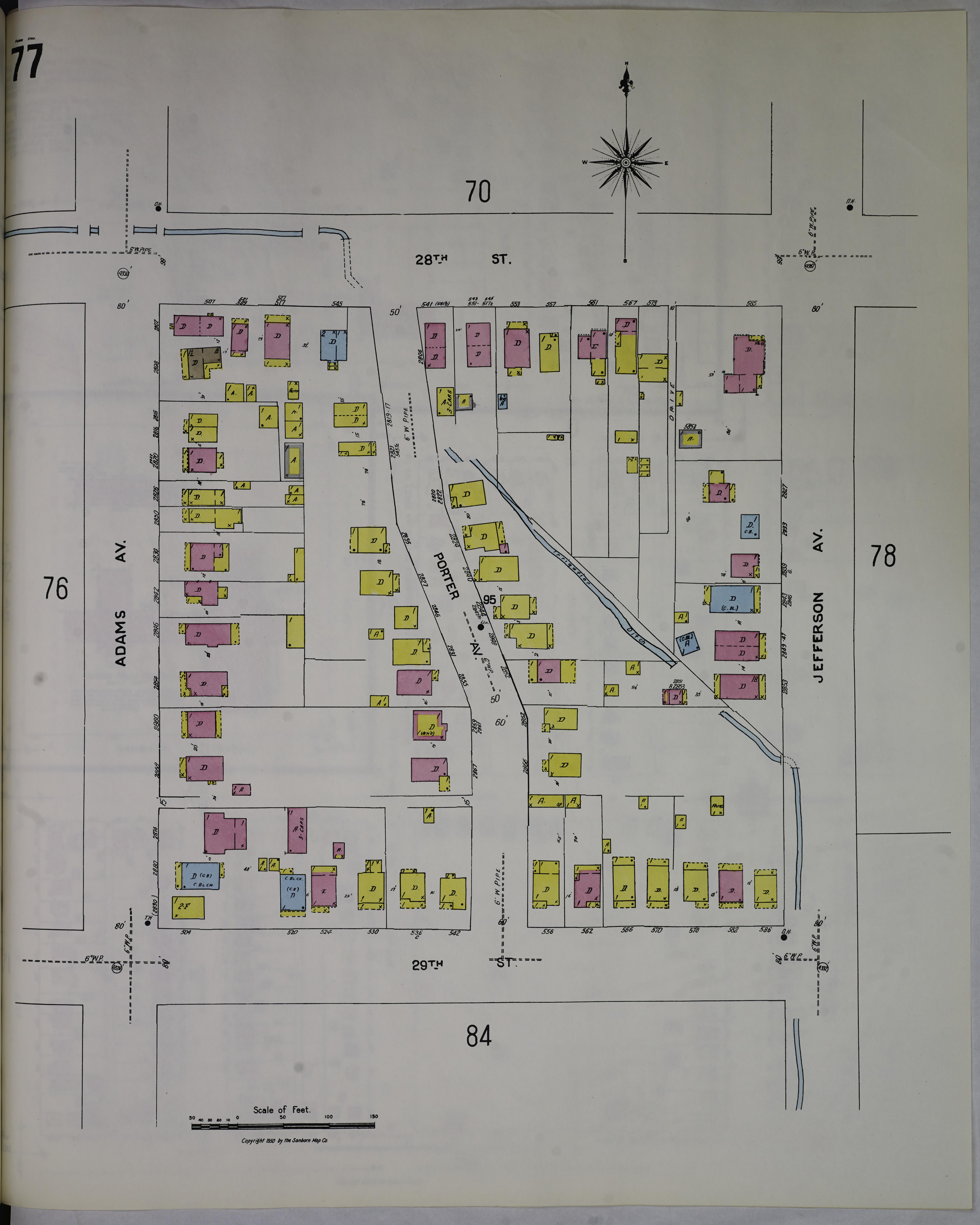
File:Sanborn Fire Insurance Map from Ogden, Weber County, Utah, 1949, Plate 0077.jpg
Jump to navigation
Jump to search
Size of this preview: 480 × 600 pixels. Other resolutions: 192 × 240 pixels | 384 × 480 pixels | 615 × 768 pixels | 819 × 1,024 pixels | 1,639 × 2,048 pixels | 6,239 × 7,796 pixels.
Original file (6,239 × 7,796 pixels, file size: 2.47 MB, MIME type: image/jpeg)
Captions
Captions
Add a one-line explanation of what this file represents
Summary
[edit]
| Description |
English: Sanborn Fire Insurance Map from Ogden, Weber County, Utah, 1949, Plate 0077 |
| Date | |
| Source | https://tile.loc.gov/image-services/iiif/service:gmd:gmd434m:g4344m:g4344om:g088771949:08877_1949-0077/full/pct:100/0/default.jpg |
| Author | Unknown author |
Licensing
[edit]
This work is in the public domain in the United States because it was published in the United States between 1929 and 1977, inclusive, without a copyright notice. For further explanation, see Commons:Hirtle chart as well as a detailed definition of "publication" for public art. Note that it may still be copyrighted in jurisdictions that do not apply the rule of the shorter term for US works (depending on the date of the author's death), such as Canada (50 p.m.a.), Mainland China (50 p.m.a., not Hong Kong or Macao), Germany (70 p.m.a.), Mexico (100 p.m.a.), Switzerland (70 p.m.a.), and other countries with individual treaties.
|
 |
File history
Click on a date/time to view the file as it appeared at that time.
| Date/Time | Thumbnail | Dimensions | User | Comment | |
|---|---|---|---|---|---|
| current | 09:36, 31 December 2023 | | 6,239 × 7,796 (2.47 MB) | Nowakki (talk | contribs) | == {{int:filedesc}} == {{Information |description={{en|1=Sanborn Fire Insurance Map from Ogden, Weber County, Utah, 1949, Plate 0077}} |date=1949 |source=https://tile.loc.gov/image-services/iiif/service:gmd:gmd434m:g4344m:g4344om:g088771949:08877_1949-0077/full/pct:100/0/default.jpg |author={{Unknown|1=Author}} }} == {{int:license-header}} == {{PD-US-no notice}} Category:Sanborn Fire Insurance Map from Ogden, Weber County, Utah, 1949 |
You cannot overwrite this file.
File usage on Commons
The following page uses this file: