File:Sanfrancisco civiccentertenderloin map.svg
Jump to navigation
Jump to search

Size of this PNG preview of this SVG file: 424 × 600 pixels. Other resolutions: 170 × 240 pixels | 339 × 480 pixels | 543 × 768 pixels | 724 × 1,024 pixels | 1,448 × 2,048 pixels | 744 × 1,052 pixels.
Original file (SVG file, nominally 744 × 1,052 pixels, file size: 496 KB)
Captions
Captions
Add a one-line explanation of what this file represents
Summary[edit]
| Description |
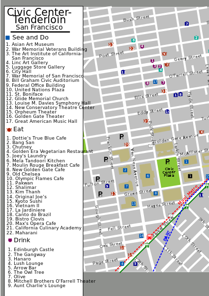
English: SVG version of a map of the Civic Center-Tenderloin area of San Francisco, California, USA. |
| Date | 8 May 2008 (original upload date) |
| Source | Own work |
| Author | (WT-en) PerryPlanet at English Wikivoyage |
| Other versions | File:Sanfrancisco civiccentertenderloin map.PNG |
Licensing[edit]
(WT-en) PerryPlanet at en.wikivoyage-old.org, the copyright holder of this work, hereby publishes it under the following license:
This file is licensed under the Creative Commons Attribution-Share Alike 1.0 Generic license.
Attribution: (WT-en) PerryPlanet at en.wikivoyage-old.org
- You are free:
- to share – to copy, distribute and transmit the work
- to remix – to adapt the work
- Under the following conditions:
- attribution – You must give appropriate credit, provide a link to the license, and indicate if changes were made. You may do so in any reasonable manner, but not in any way that suggests the licensor endorses you or your use.
- share alike – If you alter, transform, or build upon this work, you must distribute the resulting work under the same license as the original.
Original upload log[edit]
| This file was imported from Wikivoyage en. |
The original description page was here. All following user names refer to en.wikivoyage-old.
- 2012-09-13 11:57 ImportBot 744×1052 (508208 bytes) rm WT-logo
- 2008-06-02 19:22 ImportBot 744×1052 (533936 bytes) Added BART line to map. (Import from wikitravel.org/en)
- 2008-05-08 05:37 ImportBot 744×1052 (532601 bytes) SVG version of a map of the Civic Center-Tenderloin area of San Francisco, California, USA. Created by me on and finished on 5/7/08. (Import from wikitravel.org/en)
File history
Click on a date/time to view the file as it appeared at that time.
| Date/Time | Thumbnail | Dimensions | User | Comment | |
|---|---|---|---|---|---|
| current | 16:36, 19 January 2013 | | 744 × 1,052 (496 KB) | OgreBot (talk | contribs) | (BOT): Reverting to most recent version before archival |
| 16:35, 19 January 2013 |  | 744 × 1,052 (521 KB) | OgreBot (talk | contribs) | (BOT): Uploading old version of file from en.wikivoyage-old; originally uploaded on 2008-06-02 19:22:46 by (WT-en) PerryPlanet | |
| 16:35, 19 January 2013 |  | 744 × 1,052 (520 KB) | OgreBot (talk | contribs) | (BOT): Uploading old version of file from en.wikivoyage-old; originally uploaded on 2008-05-08 05:37:55 by (WT-en) PerryPlanet | |
| 13:14, 1 January 2013 |  | 744 × 1,052 (496 KB) | MGA73bot2 (talk | contribs) | {{BotMoveToCommons|en.oldwikivoyage|year={{subst:CURRENTYEAR}}|month={{subst:CURRENTMONTHNAME}}|day={{subst:CURRENTDAY}}}} == {{int:filedesc}} == {{Information |description=SVG version of a map of the Civic Center-Tenderloin area of San Francisco, Cali... |
You cannot overwrite this file.
File usage on Commons
There are no pages that use this file.
File usage on other wikis
The following other wikis use this file:
- Usage on en.wikivoyage.org