File:Sentinel-3B-Aufnahme von Nordeuropa ESA393981.jpg

Original file (2,000 × 1,731 pixels, file size: 1.73 MB, MIME type: image/jpeg)
Captions
Captions
Summary[edit]
| Description |
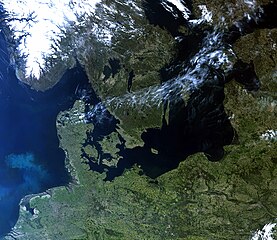
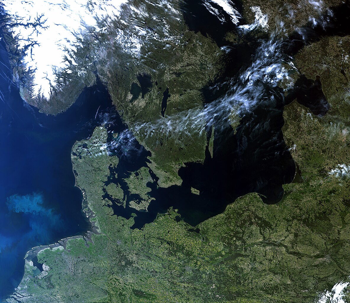
English: Der Copernicus-Satellit Sentinel-3B hat am 8. Mai 2018 um 09:33 GMT (11:33 MESZ) diese seltene wolkenfreie Sicht auf Nordeuropa aufgenommen. Merkmale auf dem Land und im Wasser sind deutlich zu erkennen, wie z.B. verschiedene Arten von Bodenbedeckung, Schnee und auch eine Phytoplanktonfahne in der Nordsee.
Das Bild wurde mit dem Ozean- und Landfarbinstrument des Satelliten aufgenommen, das 21 verschiedene Bänder, eine Auflösung von 300 m und eine Bandbreite von 1270 km aufweist. Das Gerät kann zur Überwachung von Meeresverschmutzung und Entwicklung von Ozeankulturen sowie über Land zur Überwachung des Vegetationszustandes eingesetzt werden. Das Instrumentenpaket von Sentinel-3B umfasst außerdem ein Meeres- und Landoberflächentemperatur-Radiometer, einen Radarhöhenmesser mit synthetischer Apertur und ein Mikrowellenradiometer. Sentinel-3B wurde am 25. April vom Kosmodrom Plesezk (Russland) aus gestartet und schließt sich seinem Zwilling, Sentinel-3A, im Orbit an. Die Kopplung der beiden Satelliten optimiert die Abdeckung und Datenbereitstellung für das europäische Umweltüberwachungsprogramm Copernicus. |
| Date | |
| Source | http://www.esa.int/spaceinimages/Images/2018/05/Sentinel-3B-Aufnahme_von_Nordeuropa |
| Author | European Space Agency |
| Permission (Reusing this file) |
Erstellt mit modifizierten Copernicus Sentinel-Daten (2018), bearbeitet von EUMETSAT ,CC BY-SA 3.0 IGO |
| Title | Sentinel-3B-Aufnahme von Nordeuropa |
| System | Copernicus |
| Mission | Sentinel-3 |
| Activity | Observing the Earth |
Licensing[edit]
- You are free:
- to share – to copy, distribute and transmit the work
- to remix – to adapt the work
- Under the following conditions:
- attribution – You must give appropriate credit, provide a link to the license, and indicate if changes were made. You may do so in any reasonable manner, but not in any way that suggests the licensor endorses you or your use.
- share alike – If you remix, transform, or build upon the material, you must distribute your contributions under the same or compatible license as the original.

|
This image contains data from a satellite in the Copernicus Programme, such as Sentinel-1, Sentinel-2 or Sentinel-3. Attribution is required when using this image.
Attribution: Contains modified Copernicus Sentinel data {{{year}}}
The use of Copernicus Sentinel Data is regulated under EU law (Commission Delegated Regulation (EU) No 1159/2013 and Regulation (EU) No 377/2014). Relevant excerpts:
Free access shall be given to GMES dedicated data [...] made available through GMES dissemination platforms [...].
Access to GMES dedicated data [...] shall be given for the purpose of the following use in so far as it is lawful:
GMES dedicated data [...] may be used worldwide without limitations in time.
GMES dedicated data and GMES service information are provided to users without any express or implied warranty, including as regards quality and suitability for any purpose. |
File history
Click on a date/time to view the file as it appeared at that time.
| Date/Time | Thumbnail | Dimensions | User | Comment | |
|---|---|---|---|---|---|
| current | 15:55, 9 May 2018 | | 2,000 × 1,731 (1.73 MB) | Fæ (talk | contribs) | European Space Agency, Id 393981, http://www.esa.int/spaceinimages/Images/2018/05/Sentinel-3B-Aufnahme_von_Nordeuropa, User:Fæ/Project_list/ESA |
You cannot overwrite this file.
File usage on Commons
The following page uses this file:
- File:Northern Europe ESA393950.jpg (file redirect)
File usage on other wikis
The following other wikis use this file:
- Usage on fr.wikipedia.org
- Usage on www.wikidata.org