File:Site Plan - Cana island Light Station, Cana Island Road, Baileys Harbor, Door County, WI HABS WI-376 (sheet 2 of 2) (cropped).tif
Jump to navigation
Jump to search

Size of this JPG preview of this TIF file: 748 × 599 pixels. Other resolutions: 300 × 240 pixels | 599 × 480 pixels | 959 × 768 pixels | 1,278 × 1,024 pixels | 2,556 × 2,048 pixels | 17,055 × 13,664 pixels.
Original file (17,055 × 13,664 pixels, file size: 3.08 MB, MIME type: image/tiff)
Captions
Captions
Add a one-line explanation of what this file represents
Summary[edit]
| Warning | The original file is very high-resolution. It might not load properly or could cause your browser to freeze when opened at full size. |
|---|
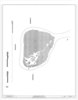
| Site Plan - Cana island Light Station, Cana Island Road, Baileys Harbor, Door County, WI | ||||
|---|---|---|---|---|
| Title |
Site Plan - Cana island Light Station, Cana Island Road, Baileys Harbor, Door County, WI |
|||
| Description |
The Kubala Washatko Architects, Inc, delineator |
|||
| Depicted place | Wisconsin; Door County; Baileys Harbor | |||
| Date | Documentation compiled after 1933 | |||
| Current location |
Library of Congress Prints and Photographs Division Washington, D.C. 20540 USA http://hdl.loc.gov/loc.pnp/pp.print |
|||
| Accession number |
HABS WI-376 (sheet 2 of 2) |
|||
| Credit line |
|
|||
| Notes |
|
|||
| References |
|
|||
| Source | https://www.loc.gov/pictures/item/wi0720.sheet.00002a | |||
| Permission (Reusing this file) |
|
|||
| Other versions | ||||

File history
Click on a date/time to view the file as it appeared at that time.
| Date/Time | Thumbnail | Dimensions | User | Comment | |
|---|---|---|---|---|---|
| current | 19:36, 21 February 2022 |  | 17,055 × 13,664 (3.08 MB) | Epiphyllumlover (talk | contribs) | File:Site Plan - Cana island Light Station, Cana Island Road, Baileys Harbor, Door County, WI HABS WI-376 (sheet 2 of 2).tif cropped -25 % horizontally, 22 % vertically, rotated 270° using CropTool with lossless mode. |
You cannot overwrite this file.
File usage on Commons
The following 2 pages use this file:
File usage on other wikis
The following other wikis use this file:
- Usage on en.wikipedia.org