File:Sn-growth.png
Jump to navigation
Jump to search

Size of this preview: 568 × 599 pixels. Other resolutions: 227 × 240 pixels | 455 × 480 pixels | 728 × 768 pixels | 1,084 × 1,144 pixels.
Original file (1,084 × 1,144 pixels, file size: 707 KB, MIME type: image/png)
Captions
Captions
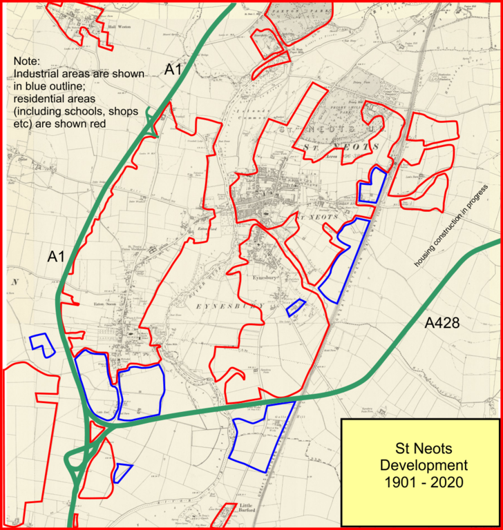
Growth of St Neots from 1901 to 2020
Summary[edit]
| Description |
English: Map showing the growth oif the built-up area of St Neots. The base map is from 1901, and the coloured outlines show the extent of the built up area in 2020; red is housing, including schools, shops, hotels and restaurants. The blue area shows industrial use. |
| Date | |
| Source | The base map is an Ordnance Survey six inch map composite dated 1901. The mapping itself is copyright-excpired, but the digitisation is copyright of the National Library of Scotland. They grant non-commecial reproduction rights CC-by-NC-SA 4.0. The rest of the image is my personal work. |
| Author | National Library of Scotland as described above. |
Licensing[edit]
This file is licensed under the Creative Commons Attribution-Share Alike 4.0 International license.
- You are free:
- to share – to copy, distribute and transmit the work
- to remix – to adapt the work
- Under the following conditions:
- attribution – You must give appropriate credit, provide a link to the license, and indicate if changes were made. You may do so in any reasonable manner, but not in any way that suggests the licensor endorses you or your use.
- share alike – If you remix, transform, or build upon the material, you must distribute your contributions under the same or compatible license as the original.
File history
Click on a date/time to view the file as it appeared at that time.
| Date/Time | Thumbnail | Dimensions | User | Comment | |
|---|---|---|---|---|---|
| current | 05:49, 12 June 2021 | | 1,084 × 1,144 (707 KB) | Afterbrunel (talk | contribs) | Uploaded a work by National Library of Scotland as described above. from The base map is an Ordnance Survey six inch map composite dated 1901. The mapping itself is copyright-excpired, but the digitisation is copyright of the National Library of Scotland. They grant non-commecial reproduction rights CC-by-NC-SA 4.0. The rest of the image is my personal work. with UploadWizard |
You cannot overwrite this file.
File usage on Commons
There are no pages that use this file.
File usage on other wikis
The following other wikis use this file:
- Usage on en.wikipedia.org