File:Snow across the Great Plains (MODIS 2015-12-10).jpg

Original file (5,600 × 7,200 pixels, file size: 8.12 MB, MIME type: image/jpeg)
Captions
Captions
Summary[edit]
.jpg&action=edit§ion=1)
| Description |
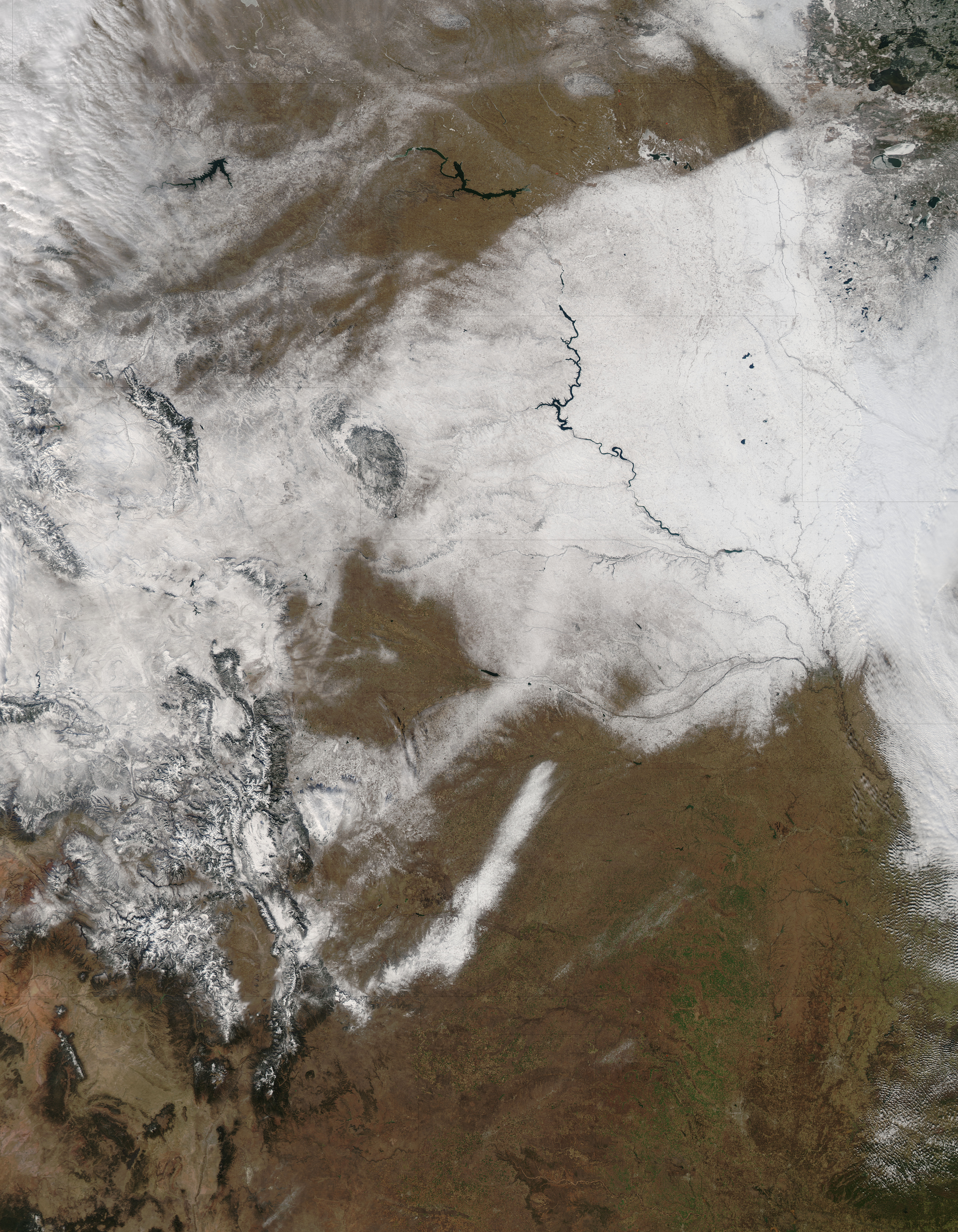
English: A winter storm blew across the Great Plains and upper Midwest from late November to early December 2015, dumping up to a foot of snow in some areas and a glistening of ice in others. The storm, named Delphi, was the fourth named winter storm of the season. It began on November 29 as a surface low became fixed over northern Great Plains and western Great Lakes, wrapping cold surface air into moist conditions. Delphi continued to dump snow, close schools, and snarl traffic through December 1.
The Weather Channel reports that South Dakota, northern Nebraska, southwest Minnesota and northwest Iowa received the heaviest snows, between 8 to 12 inches (20 to 30 cm). Valentine, Nebraska and Mosher, South Dakota were on top on the totals, with each reporting 12 in (30 cm) of fresh snow. Road conditions were poor in Iowa, which reported icy roads, and in Minnesota where at least two people were reported to have been killed in weather-related traffic accidents. Weather Underground reported that the Minnesota State Police reported nearly 400 crashes and spinouts on state roads between midnight and 9:00 p.m. local time on November 30. The Moderate Resolution Imaging Spectroradiometer (MODIS) aboard NASA�s Aqua satellite captured this true-color image of the aftermath of the winter storm on December 2. In the southwest section of the image, snow covers (from south to north) the Rocky Mountains of Colorado and Wyoming, with a dusting in Montana. The central tier of states affected, from north to south, are North Dakota, South Dakota and Nebraska, with a single swath of snow across western Kansas. South Dakota, cut by the unfrozen Missouri River, is nearly completely blanketed in white. Along the eastern edge of the image, from north to south, snow covers Minnesota, Iowa and northern Missouri. |
||
| Date | Taken on 2 December 2015 | ||
| Source |
Snow across the Great Plains (direct link)
|
||
| Author | Jeff Schmaltz, MODIS Land Rapid Response Team, NASA GSFC |
| This media is a product of the Aqua mission Credit and attribution belongs to the mission team, if not already specified in the "author" row |
Licensing[edit]
.jpg&action=edit§ion=2)
| This file is in the public domain in the United States because it was solely created by NASA. NASA copyright policy states that "NASA material is not protected by copyright unless noted". (See Template:PD-USGov, NASA copyright policy page or JPL Image Use Policy.) | ||
 |
Warnings:
|
File history
Click on a date/time to view the file as it appeared at that time.
| Date/Time | Thumbnail | Dimensions | User | Comment | |
|---|---|---|---|---|---|
| current | 09:48, 15 February 2024 | | 5,600 × 7,200 (8.12 MB) | OptimusPrimeBot (talk | contribs) | #Spacemedia - Upload of http://modis.gsfc.nasa.gov/gallery/images/image12102015_250m.jpg via Commons:Spacemedia |
You cannot overwrite this file.
File usage on Commons
There are no pages that use this file.
.jpg&oldid=852062240)