File:Snow in British Columbia and Alberta, Canada (MODIS 2018-10-07).jpg

Original file (5,864 × 4,628 pixels, file size: 4.47 MB, MIME type: image/jpeg)
Captions
Captions
Summary[edit]
.jpg&action=edit§ion=1)
| Description |
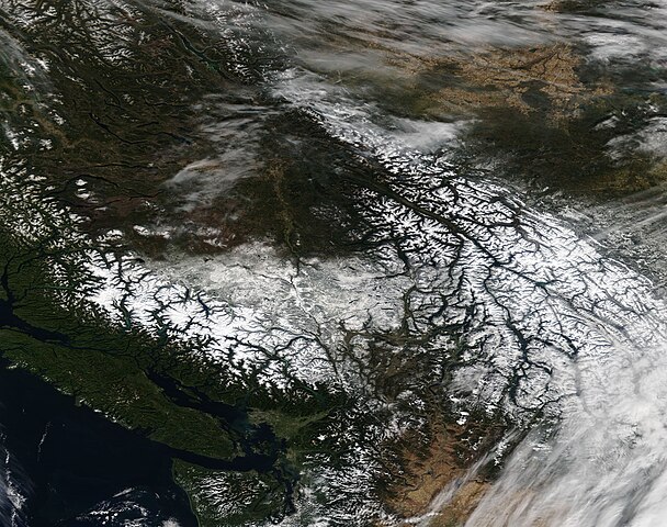
English: A late summer snowstorm dropped a blanket of white across much of the Canadian provinces of British Columbia and Alberta on September 12-13, thanks to a strong cold front moving south out of the Northern Territories and meeting up with moisture streaming inland from the Pacific Ocean. The early winter chill remained into October, allowing the early snowfall to remain intact, particularly in the higher elevations of the mountains.
On October 2, another, stronger system dumped additional snow across the region. Southern Alberta, which had escaped the earlier flakes, received their first snowfall – and it was impressive. According to several media reports, the city of Calgary, in southern Alberta, experienced a record-breaking 15 – 25 cm (6 to 9.8 inches) of new-fallen snow within 24 hours. The previous record for October 2 in Calgary was set in 1954, with only about 5 cm (2 in), according to CBC News. Other areas in southwestern Alberta reportedly received as much as 40 cm (16 in) from the same storm. The usual first snow response in the city begins about October 15, but the response was brisk as people tried to plow out of the deep, new layer of white. Due to dangerous conditions, many roads were closed, including part of the Trans-Canada Highway, as motorists became stuck in the fast-falling snow. Multi-hour road jams were faced in a number of ways, according to media sources. There were stories of people nibbling their last stash of chocolate and tales of people pulling together to free other drivers which had slid off the icy road. One of the more unusual stories involved the “pretty darn Canadian” response of Jens Lindemann, a trumpet soloist who was traveling from Los Angeles, California to Vancouver, Canada when he met the fierce storm. According to Global News, after sitting – unmoving – in traffic west of Calgary for about six hours and after his concert was cancelled, Jens decided to step out in the wintery conditions and give an impromptu concert to his fellow snow-bound motorists, much to their enthusiastic delight. The Moderate Resolution Imaging Spectroradiometer (MODIS) aboard NASA’s Terra satellite acquired a true-color image of snow across British Columbia and Alberta, Canada on October 2, 2018. |
||
| Date | Taken on 4 October 2018 | ||
| Source |
Snow in British Columbia and Alberta, Canada (direct link)
|
||
| Author | MODIS Land Rapid Response Team, NASA GSFC |
| This media is a product of the Terra mission Credit and attribution belongs to the mission team, if not already specified in the "author" row |
Licensing[edit]
.jpg&action=edit§ion=2)
| This file is in the public domain in the United States because it was solely created by NASA. NASA copyright policy states that "NASA material is not protected by copyright unless noted". (See Template:PD-USGov, NASA copyright policy page or JPL Image Use Policy.) | ||
 |
Warnings:
|
File history
Click on a date/time to view the file as it appeared at that time.
| Date/Time | Thumbnail | Dimensions | User | Comment | |
|---|---|---|---|---|---|
| current | 01:28, 17 February 2024 | | 5,864 × 4,628 (4.47 MB) | OptimusPrimeBot (talk | contribs) | #Spacemedia - Upload of http://modis.gsfc.nasa.gov/gallery/images/image10072018_250m.jpg via Commons:Spacemedia |
You cannot overwrite this file.
File usage on Commons
There are no pages that use this file.
.jpg&oldid=852927207)