File:Snow in the mountains of western United States (MODIS 2015-11-20).jpg

Original file (7,200 × 5,600 pixels, file size: 7.5 MB, MIME type: image/jpeg)
Captions
Captions
Summary
[edit].jpg&action=edit§ion=1)
| Description |
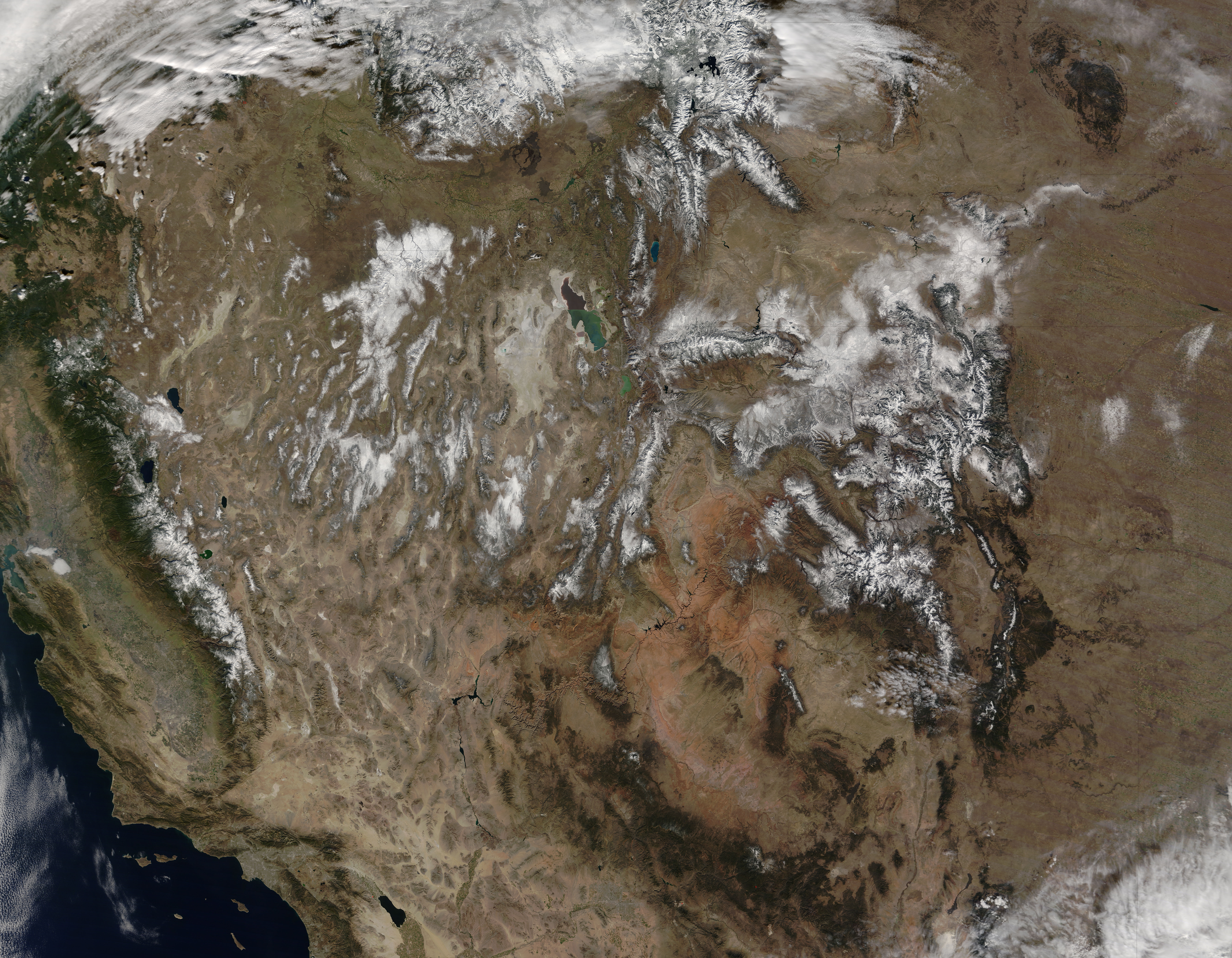
English: Parts of Canada and the western United States were doused with wintery weather in mid-November 2015. Some of the precipitation fell as snow and some as cold rain. Whether it is the beginning of a wet El Ni�o winter or a break in persistent drought remains to be seen.
The Moderate Resolution Imaging Spectroradiometer (MODIS) on NASA�s Terra satellite captured this true-color image on November 14 after storms dropped snow across the western United States from California to Colorado. In the Pacific Northwest, between November 12 and 16, a stream of moisture from the Pacific Ocean, known as an atmospheric river, pummeled Washington. The lower elevations of the Olympic mountains received 250 mm (10 in) of rain, according to the Seattle Times. Precipitation fell as snow at higher elevations. Previous research has shown that El Ni�o appears to influence atmospheric river events in California. During El Ni�o winters, atmospheric rivers tend to carry more water vapor to California, leading to more intense precipitation. But the streams of airborne moisture also tend to be warmer during El Ni�o. How the current El Ni�o affects drought in California and other western states is an open question. Strong El Ni�os often influence on winter weather across the country, but other factors can play a role, including the Arctic Oscillation and the Madden-Julian Oscillation. According to the U.S. winter outlook issued by NOAA�s Climate Prediction Center (CPC), a wetter-than-average winter is expected across the lower half of the United States, from central and southern California across Texas to Florida and some of the East Coast. The CPC outlook notes that �some improvement is likely in central and southern California by the end of January, but not drought removal.� |
||
| Date | Taken on 14 October 2015 | ||
| Source |
Snow in the mountains of western United States (direct link)
|
||
| Author | Jeff Schmaltz, MODIS Land Rapid Response Team, NASA GSFC |
| This media is a product of the Terra mission Credit and attribution belongs to the mission team, if not already specified in the "author" row |
Licensing
[edit].jpg&action=edit§ion=2)
| This file is in the public domain in the United States because it was solely created by NASA. NASA copyright policy states that "NASA material is not protected by copyright unless noted". (See Template:PD-USGov, NASA copyright policy page or JPL Image Use Policy.) | ||
 |
Warnings:
|
File history
Click on a date/time to view the file as it appeared at that time.
| Date/Time | Thumbnail | Dimensions | User | Comment | |
|---|---|---|---|---|---|
| current | 09:50, 15 February 2024 | | 7,200 × 5,600 (7.5 MB) | OptimusPrimeBot (talk | contribs) | #Spacemedia - Upload of http://modis.gsfc.nasa.gov/gallery/images/image11202015_250m.jpg via Commons:Spacemedia |
You cannot overwrite this file.
File usage on Commons
There are no pages that use this file.
.jpg&oldid=852062309)