File:South Orkney Islands-be.svg
Jump to navigation
Jump to search

Size of this PNG preview of this SVG file: 800 × 476 pixels. Other resolutions: 320 × 190 pixels | 640 × 381 pixels | 1,024 × 609 pixels | 1,280 × 761 pixels | 2,560 × 1,523 pixels | 2,303 × 1,370 pixels.
Original file (SVG file, nominally 2,303 × 1,370 pixels, file size: 251 KB)
Captions
Captions
Add a one-line explanation of what this file represents
Summary[edit]
| Description |
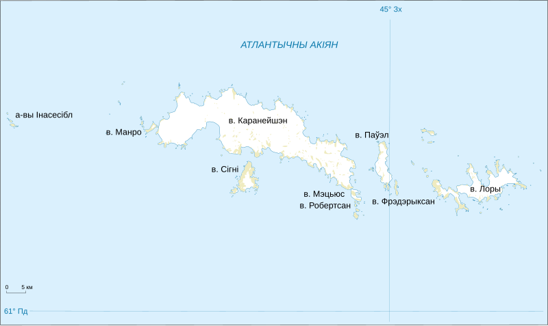
English: Belarusian version of the map of South Orkney Islands. |
| Date | |
| Source | File:South_Orkney_Islands-en.svg |
| Author | Original: Shakki, this file Frantishak |
| Other versions |
|


Licensing[edit]
This image is in the public domain in the United States because it only contains materials that originally came from the United States Geological Survey, an agency of the United States Department of the Interior. For more information, see the official USGS copyright policy.
|
File history
Click on a date/time to view the file as it appeared at that time.
| Date/Time | Thumbnail | Dimensions | User | Comment | |
|---|---|---|---|---|---|
| current | 04:26, 4 October 2014 | | 2,303 × 1,370 (251 KB) | Frantishak (talk | contribs) | User created page with UploadWizard |
You cannot overwrite this file.
File usage on Commons
The following 6 pages use this file: