File:Steevlied op minuutkaart uit 1832.jpg
Jump to navigation
Jump to search

Size of this preview: 800 × 494 pixels. Other resolutions: 320 × 198 pixels | 640 × 396 pixels | 1,024 × 633 pixels | 1,445 × 893 pixels.
Original file (1,445 × 893 pixels, file size: 268 KB, MIME type: image/jpeg)
Captions
Captions
Add a one-line explanation of what this file represents
Summary[edit]
| Description |
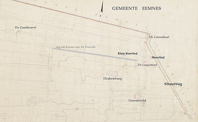
Nederlands: Detail van de kadasterkaart uit 1832 van de Gemeente Baarn, sectie C. Hierop staan De Catoenbaal (nr. 23), Steevlied (nr. 26), Klein Steevlied (nr. 31), De Langenhoef (nr. 28) en Drakenburg (nr. 97). |
| Date | circa 1833 |
| Source | https://beeldbank.cultureelerfgoed.nl/rce-mediabank/detail/a7634e76-94d7-11e5-a7e2-1fdaa5e8d5e9/media/a9d4162c-c33b-8159-680e-b30e19277bbf |
| Author | Kadastrale kaart 1811-1832: minuutplan Baarn, Utrecht, sectie C, blad 01 (MIN06008C01) |
Licensing[edit]
|
This work is in the public domain in its country of origin and other countries and areas where the copyright term is the author's life plus 70 years or fewer. This work is in the public domain in the United States because it was published (or registered with the U.S. Copyright Office) before January 1, 1929. | |
| This file has been identified as being free of known restrictions under copyright law, including all related and neighboring rights. | |
File history
Click on a date/time to view the file as it appeared at that time.
| Date/Time | Thumbnail | Dimensions | User | Comment | |
|---|---|---|---|---|---|
| current | 12:29, 30 November 2020 | | 1,445 × 893 (268 KB) | Tulp8 (talk | contribs) | Uploaded a work by Kadastrale kaart 1811-1832: minuutplan Baarn, Utrecht, sectie C, blad 01 (MIN06008C01) from https://beeldbank.cultureelerfgoed.nl/rce-mediabank/detail/a7634e76-94d7-11e5-a7e2-1fdaa5e8d5e9/media/a9d4162c-c33b-8159-680e-b30e19277bbf with UploadWizard |
You cannot overwrite this file.
File usage on Commons
There are no pages that use this file.
File usage on other wikis
The following other wikis use this file:
- Usage on nl.wikipedia.org