File:StrassenbahnNetzplanKairo1996.png
Jump to navigation
Jump to search

Size of this preview: 294 × 599 pixels. Other resolutions: 117 × 240 pixels | 235 × 480 pixels | 377 × 768 pixels | 502 × 1,024 pixels | 1,408 × 2,870 pixels.
Original file (1,408 × 2,870 pixels, file size: 254 KB, MIME type: image/png)
Captions
Captions
Add a one-line explanation of what this file represents
| Description |
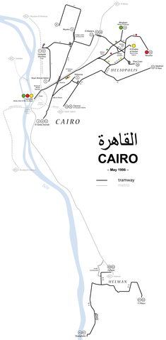
Deutsch: Straßenbahn-Netzplan Kairo mit Teilnetzen Heliopolis und Heluan 1996
English: Public transport map of Greater Cairo, 1996 (with Heliopolis and Helwan)
Français : Réseau des tramways du Caire avec Héliopolis et Helwan 1996 |
| Date | see file history |
| Source | Own work |
| Author | Maximilian Dörrbecker (Chumwa), using this map by NordNordWest |
| Permission (Reusing this file) |
I, the copyright holder of this work, hereby publish it under the following license: This file is licensed under the Creative Commons Attribution-Share Alike 2.5 Generic license.
Sie dürfen das Bild zu den folgenden Bedingungen nutzen:
|
| Other versions |
|


File history
Click on a date/time to view the file as it appeared at that time.
| Date/Time | Thumbnail | Dimensions | User | Comment | |
|---|---|---|---|---|---|
| current | 20:45, 21 October 2010 | | 1,408 × 2,870 (254 KB) | Chumwa (talk | contribs) | digitalisized version |
| 21:45, 25 July 2006 |  | 1,500 × 1,543 (172 KB) | Chumwa (talk | contribs) | *'''Description:''' Straßenbahn-Netzplan Kairo 1996 *'''Source:''' Maximilian Dörrbecker {{GFDL}} Category:Cairo Category:public transportCategory:mapsCategory:streetcarCategory:Maximilian DörrbeckerCategory:Karte[[Category:Ö |
You cannot overwrite this file.
File usage on Commons
The following 6 pages use this file:
File usage on other wikis
The following other wikis use this file:
- Usage on arz.wikipedia.org
- Usage on de.wikipedia.org
- Usage on pl.wikipedia.org
- Usage on www.wikidata.org