File:Superfund sites.svg
Jump to navigation
Jump to search

Size of this PNG preview of this SVG file: 800 × 444 pixels. Other resolutions: 320 × 178 pixels | 640 × 356 pixels | 1,024 × 569 pixels | 1,280 × 711 pixels | 2,560 × 1,422 pixels | 900 × 500 pixels.
Original file (SVG file, nominally 900 × 500 pixels, file size: 2.33 MB)
Captions
Captions
Add a one-line explanation of what this file represents
Summary[edit]
| Description |
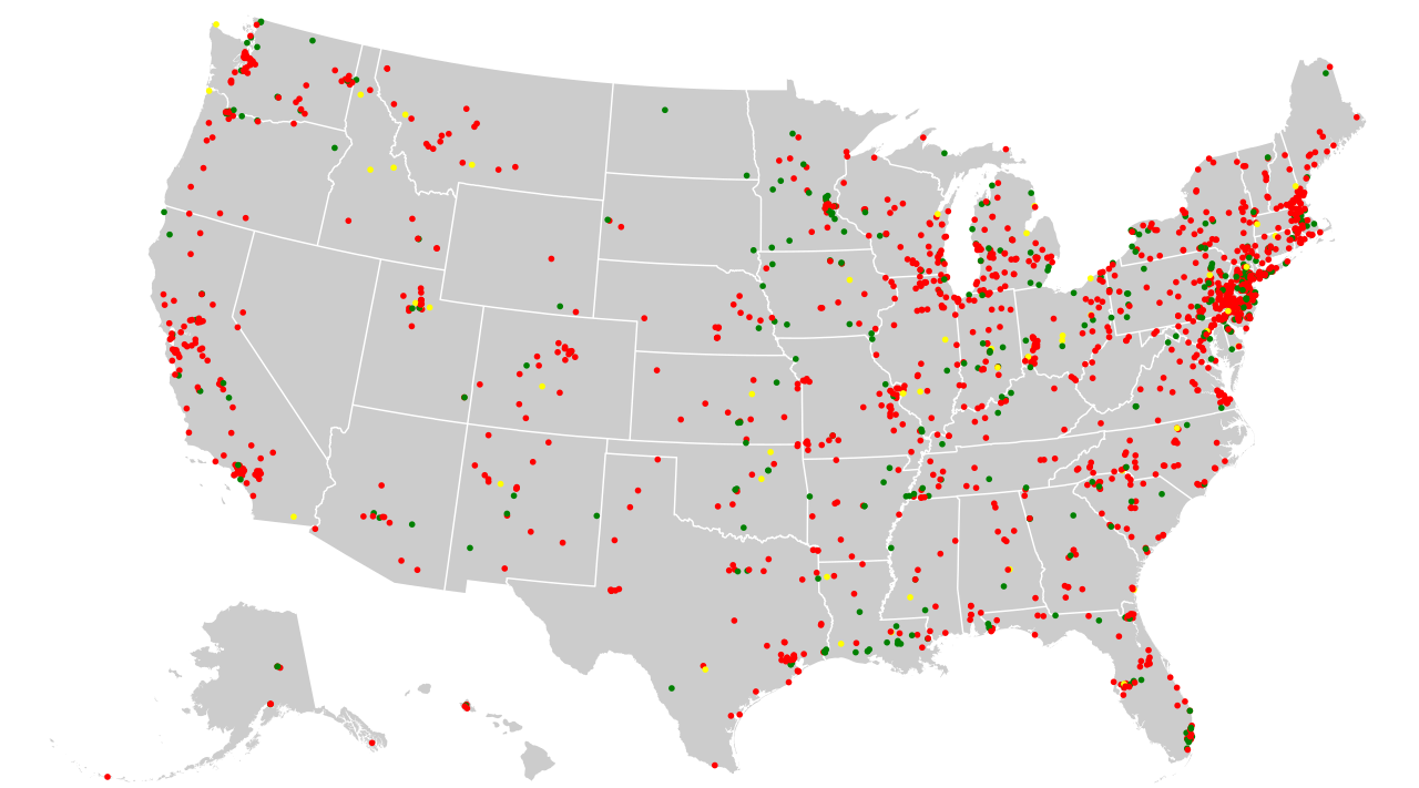
English: Map of Superfund sites in the United States. Red indicates currently on final National Priority List, yellow is proposed, green is deleted (usually meaning having been cleaned up). Data from United States Environmental Protection Agency CERCLIS database, retrieved February 12, 2015 with last update reported as October 25, 2013. A live map of Superfund sites is available at https://www.epa.gov/superfund/search-superfund-sites-where-you-live#map |
| Date | |
| Source | Own work |
| Author | skew-t |
Licensing[edit]
I, the copyright holder of this work, hereby publish it under the following license:
This file is licensed under the Creative Commons Attribution-Share Alike 3.0 Unported license.
- You are free:
- to share – to copy, distribute and transmit the work
- to remix – to adapt the work
- Under the following conditions:
- attribution – You must give appropriate credit, provide a link to the license, and indicate if changes were made. You may do so in any reasonable manner, but not in any way that suggests the licensor endorses you or your use.
- share alike – If you remix, transform, or build upon the material, you must distribute your contributions under the same or compatible license as the original.
File history
Click on a date/time to view the file as it appeared at that time.
| Date/Time | Thumbnail | Dimensions | User | Comment | |
|---|---|---|---|---|---|
| current | 09:34, 13 February 2015 | | 900 × 500 (2.33 MB) | Skew-t (talk | contribs) | update with October 25, 2013 data |
| 19:36, 2 August 2011 |  | 643 × 399 (687 KB) | Renamed user KdYpUvMgT (talk | contribs) | red ones over yellow ones over green ones | |
| 06:36, 26 April 2010 |  | 643 × 399 (687 KB) | Skew-t (talk | contribs) | update with data from March 31, 2010 | |
| 09:25, 26 December 2008 |  | 810 × 510 (839 KB) | Skew-t (talk | contribs) | {{Information |Description={{en|1=Map of Superfund sites in the contiguous United States. Red indicates currently on final National Priority List, yellow is proposed, green is deleted (usually meaning having been cleaned up). Data from United States Env |
You cannot overwrite this file.
File usage on Commons
The following page uses this file:
File usage on other wikis
The following other wikis use this file:
- Usage on ar.wikipedia.org
- Usage on de.wikipedia.org
- Usage on en.wikipedia.org
- Superfund
- National Priorities List
- List of Superfund sites
- Wikipedia:WikiProject Superfund
- User:Skew-t/Gallery
- User:Mesoderm/To do
- User:Buaidh/sandbox
- Template:Portal/doc/all
- User:Kazkaskazkasako/Books/Physical sciences
- Non-aqueous phase liquid
- Wikipedia:Userboxes/WikiProjects/United States
- Wikipedia:Userboxes/WikiProjects/alphabetical/26
- Wikipedia:Userboxes/WikiProjects/Government
- User:Knowledgengine/Non-aqueous phase liquid
- Usage on fr.wikipedia.org
- Usage on tum.wikipedia.org