File:Tabernakel cartouche on the Holy Land map by Funck.jpg
Jump to navigation
Jump to search

Size of this preview: 800 × 510 pixels. Other resolutions: 320 × 204 pixels | 640 × 408 pixels | 1,024 × 652 pixels | 1,345 × 857 pixels.
Original file (1,345 × 857 pixels, file size: 277 KB, MIME type: image/jpeg)
Captions
Captions
Add a one-line explanation of what this file represents
| Novissima totius Terrae Sanctae Sive Promissionis Descriptio. | ||||||
|---|---|---|---|---|---|---|
| Artist | ||||||
| Title |
Novissima totius Terrae Sanctae Sive Promissionis Descriptio. |
|||||
| Description |
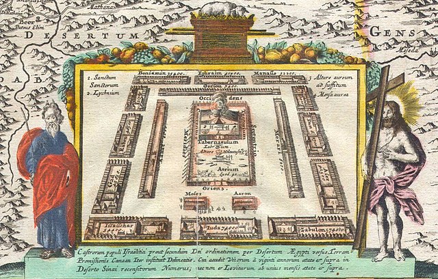
English: An altogether stunning map of the Israel, Palestine, or the Holy Land. Issued in 1720 by David Funck of Nuremburg and geographically based upon Visscher’s Map of 1659 and De Wit’s Map of 1670. The shoreline runs from Sidon to Egypt along an East – West orientation. Divided according to the Tribes of Israel on both side of the River Jordan. Bottom center features a plan of the Temple of Solomon with the Ark of the Covenant featuring prominently. Moses and Jesus stand to either side of the plan. Title cartouche appears at the top of the map and features four cherubs, one of which holds the Tablets of Moses or the Ten Commandments. In the Dead Sea (Mare Mortuum) the destroyed cities of Sodom, Gamora, Sebim and Adama are depicted. At sea, 14 ships sail the Mediterranean. All text is in Latin. |
|||||
| Date | 1720 | |||||
| Dimensions | height: 18.5 in (46.9 cm); width: 22 in (55.8 cm) | |||||
| Accession number |
Geographicus link: TerraeSanctae-funck-1720 |
|||||
| Source/Photographer |
|
|||||
| Permission (Reusing this file) |
|
|||||
| Other versions | ||||||

File history
Click on a date/time to view the file as it appeared at that time.
| Date/Time | Thumbnail | Dimensions | User | Comment | |
|---|---|---|---|---|---|
| current | 12:15, 28 November 2022 | | 1,345 × 857 (277 KB) | Enyavar (talk | contribs) | File:1720 Funck Map of Israel - Palestine - Holy Land - Geographicus - TerraeSanctae-funck-1720.jpg cropped 66 % horizontally, 75 % vertically using CropTool with precise mode. |
You cannot overwrite this file.
File usage on Commons
The following 2 pages use this file: