File:Tephra fall from 1991 eruption of Mt Pinatubo.gif
Jump to navigation
Jump to search

No higher resolution available.
Tephra_fall_from_1991_eruption_of_Mt_Pinatubo.gif (600 × 425 pixels, file size: 25 KB, MIME type: image/gif)
Captions
Captions
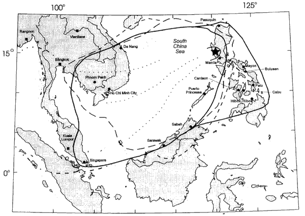
Path of the ash and debris caused by the eruption of Mt. Pinatubo
Area over which tephra from 1991 eruption of Mt Pinatubo fell.
This image is in the public domain in the United States because it only contains materials that originally came from the United States Geological Survey, an agency of the United States Department of the Interior. For more information, see the official USGS copyright policy.
|
File history
Click on a date/time to view the file as it appeared at that time.
| Date/Time | Thumbnail | Dimensions | User | Comment | |
|---|---|---|---|---|---|
| current | 09:35, 8 March 2006 | | 600 × 425 (25 KB) | Magalhães (talk | contribs) | Area over which tephra from 1991 eruption of Mt Pinatubo fell. Source: [http://pubs.usgs.gov/pinatubo/paladio/fig9.gif Fig.9] on [http://pubs.usgs.gov/pinatubo/paladio]. {{PD-USGov-Interior-USGS}} |
You cannot overwrite this file.
File usage on Commons
There are no pages that use this file.
File usage on other wikis
The following other wikis use this file:
- Usage on en.wikipedia.org
- Usage on he.wikipedia.org
- Usage on ja.wikipedia.org
- Usage on nl.wikipedia.org
- Usage on pam.wikipedia.org
- Usage on uk.wikipedia.org
- Usage on zh.wikipedia.org