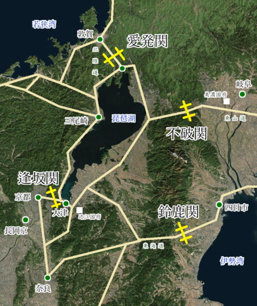
File:Three barriers in Japan.png
From Wikimedia Commons, the free media repository
Jump to navigation
Jump to search

Size of this preview: 503 × 599 pixels. Other resolutions: 201 × 240 pixels | 403 × 480 pixels | 902 × 1,074 pixels.
Original file (902 × 1,074 pixels, file size: 1.95 MB, MIME type: image/png)
File information
Structured data
Captions
Captions
Add a one-line explanation of what this file represents
Summary[edit]
| DescriptionThree barriers in Japan.png | |
| Date | |
| Source | Own work。舘野和己「古代越前国と愛発関」(福井県立図書館文書館)を参照。 |
| Author | Qrsk075 |
Licensing[edit]
I, the copyright holder of this work, hereby publish it under the following license:
This file is licensed under the Creative Commons Attribution-Share Alike 4.0 International license.
- You are free:
- to share – to copy, distribute and transmit the work
- to remix – to adapt the work
- Under the following conditions:
- attribution – You must give appropriate credit, provide a link to the license, and indicate if changes were made. You may do so in any reasonable manner, but not in any way that suggests the licensor endorses you or your use.
- share alike – If you remix, transform, or build upon the material, you must distribute your contributions under the same or compatible license as the original.
| The Landsat satellite pictures are used for this image. The data came from Global Land Cover Facility (GLCF), and are processed with Kashmir 3D. |
File history
Click on a date/time to view the file as it appeared at that time.
| Date/Time | Thumbnail | Dimensions | User | Comment | |
|---|---|---|---|---|---|
| current | 06:50, 10 September 2017 |  | 902 × 1,074 (1.95 MB) | Qrsk075 (talk | contribs) | update |
| 06:32, 10 September 2017 |  | 902 × 1,074 (2.06 MB) | Qrsk075 (talk | contribs) | User created page with UploadWizard |
You cannot overwrite this file.
File usage on Commons
The following page uses this file:
File usage on other wikis
The following other wikis use this file:
Metadata
This file contains additional information such as Exif metadata which may have been added by the digital camera, scanner, or software program used to create or digitize it. If the file has been modified from its original state, some details such as the timestamp may not fully reflect those of the original file. The timestamp is only as accurate as the clock in the camera, and it may be completely wrong.
| Horizontal resolution | 37.8 dpc |
|---|---|
| Vertical resolution | 37.8 dpc |