File:Topographischer Atlas des Koenigreichs Württemberg - Blatt 2 Mergentheim.jpg

Original file (2,662 × 2,660 pixels, file size: 4.74 MB, MIME type: image/jpeg)
Captions
Captions
Summary[edit]
| Description |
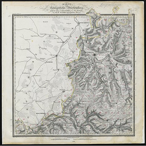
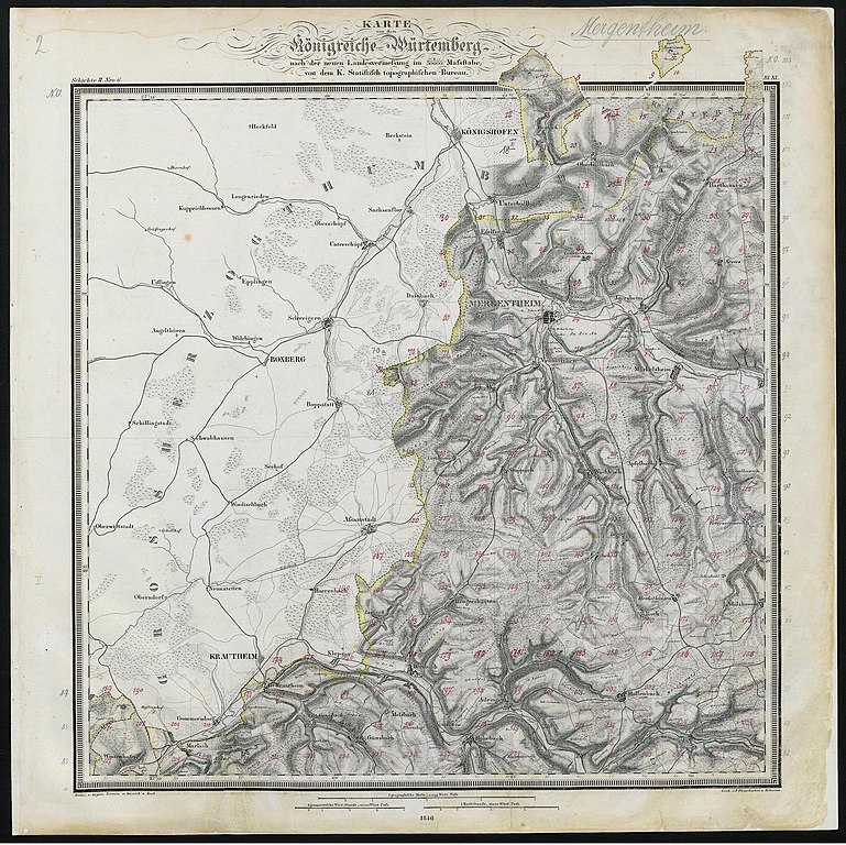
Deutsch: Topographischer Atlas des Koenigreichs Württemberg. Maßstab 1:50.000. Blatt 2, Mergentheim. Übersicht der Einzelblätter → hier. |
| Date | |
| Source |
Topographischer Atlas des Koenigreichs Württemberg: im Masstabe 1 : 50 000; in 55 Blättern; 1821–1851. Stuttgart, Tübingen, 1851. Scan: Universitätsbibliothek Tübingen, LI 9. |
| Author | Statistisch-Topographisches Bureau des Königreichs Württemberg |
| Other versions |
,_Ahorn_(Baden),_Assamstadt).jpg)
_mit_mehreren_heutigen_Stadtteilen.jpg)
Licensing[edit]
|
This work is in the public domain in its country of origin and other countries and areas where the copyright term is the author's life plus 70 years or fewer.
| |
| This file has been identified as being free of known restrictions under copyright law, including all related and neighboring rights. | |
File history
Click on a date/time to view the file as it appeared at that time.
| Date/Time | Thumbnail | Dimensions | User | Comment | |
|---|---|---|---|---|---|
| current | 12:52, 28 October 2014 | | 2,662 × 2,660 (4.74 MB) | Torana (talk | contribs) | VicuñaUploader 1.20 |
You cannot overwrite this file.
File usage on Commons
The following 4 pages use this file:
- User:Torana/Topographischer Atlas des Koenigreichs Württemberg
- User:Triplec85/Ahorn (Baden) by year
- File:1851 Bad Mergentheim (Bad Mergentheim) mit mehreren heutigen Stadtteilen.jpg
- File:Topographischer Atlas des Koenigreichs Württemberg - Blatt 2 Mergentheim (links Nordbaden mit Lauda-Königshofen, Boxberg (Baden), Ahorn (Baden), Assamstadt).jpg
- Topographischer Atlas des Koenigreichs Württemberg (Universitätsbibiothek Tübingen)
- Topographischer Atlas des Koenigreichs Württemberg (Universitätsbibiothek Tübingen) maps of Main-Tauber-Kreis
- 1851 maps of Main-Tauber-Kreis
- Maps of Deubach (Lauda-Königshofen)
- Tauber in Main-Tauber-Kreis in 1851
- 19th-century maps of Bad Mergentheim
- 19th-century maps of Igersheim
- 19th-century maps of Niederstetten
- 19th-century maps of Lauda-Königshofen
- 19th-century maps of Boxberg (Baden)
- 19th-century maps of Ahorn (Baden)
- 19th-century maps of Assamstadt