File:Towns of Miami-Dade County Florida 800px.png
Jump to navigation
Jump to search
Size of this preview: 514 × 599 pixels. Other resolutions: 206 × 240 pixels | 412 × 480 pixels.
Original file (800 × 933 pixels, file size: 35 KB, MIME type: image/png)
Captions
Captions
Add a one-line explanation of what this file represents
Summary
[edit]
| Description |
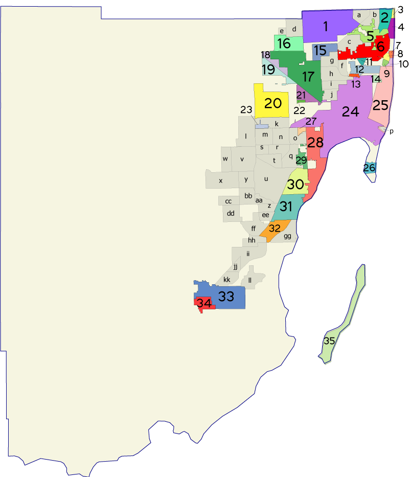
Map of Miami-Dade County in Florida (USA), showing city limits of cities/towns in the county, labeled with numbers on bright colors, letters on gray areas. Most of the map covers vacant space; see below: Map labels. Map was created using coordinate data from US Census Bureau, modified in accordance with incorporation data from 2000-2005 in Adobe Illustrator. |
| Date | |
| Source | Own work |
| Author | User:Bastique |
| Other versions |
Same map narrowed 20% by compression, with numbers redrawn 40% larger on earth tones and towns magnified 22%: |
Licensing
[edit]

|
Permission is granted to copy, distribute and/or modify this document under the terms of the GNU Free Documentation License, Version 1.2 or any later version published by the Free Software Foundation; with no Invariant Sections, no Front-Cover Texts, and no Back-Cover Texts. A copy of the license is included in the section entitled GNU Free Documentation License. |
| This file is licensed under the Creative Commons Attribution-Share Alike 3.0 Unported license. | ||
| ||
| This licensing tag was added to this file as part of the GFDL licensing update. |
Map labels
[edit]
The various cities, towns and villages are numbered on bright-colored areas as follows:
 1 - City of Miami Gardens       2 - City of Aventura
 3 - Town of Golden Beach        4 - City of Sunny Isles Beach
 5 - City of North Miami Beach   6 - City of North Miami
 7 - Village of Bal Harbour      8 - Town of Bay Harbor Islands
 9 - Village of Indian Creek    10 - Town of Surfside
----------------------------------------------------------------
11 - Village of Biscayne Park   12 - Village of Miami Shores
13 - Village of El Portal       14 - Village of North Bay Village
15 - City of Opa-locka          16 - Town of Miami Lakes
17 - City of Hialeah            18 - City of Hialeah Gardens
19 - Town of Medley             20 - City of Doral
----------------------------------------------------------------
21 - City of Miami Springs      22 - Village of Virginia Gardens
23 - City of Sweetwater         24 - City of Miami
25 - City of Miami Beach        26 - Village of Key Biscayne
27 - City of West Miami         28 - City of Coral Gables
29 - City of South Miami        30 - Village of Pinecrest
---------------------------------------------------------------
31 - Village of Palmetto Bay    32 - City of Cutler Bay
33 - City of Homestead          34 - City of Florida City
35 - City of Islandia
The other areas are labeled with letters on gray areas.
File history
Click on a date/time to view the file as it appeared at that time.
| Date/Time | Thumbnail | Dimensions | User | Comment | |
|---|---|---|---|---|---|
| current | 01:51, 7 January 2006 | | 800 × 933 (35 KB) | Bastique (talk | contribs) | Created using coordinate data from US Census Bureau, modified in accordance with incorporation data from 2000-2005 in Adobe Illustrator. {{GDFL}} Category:Maps of Florida Category:Miami-Dade County, Florida [[ |
You cannot overwrite this file.
File usage on Commons
The following page uses this file:
File usage on other wikis
The following other wikis use this file:
- Usage on fr.wikipedia.org