File:Transsib no names.svg

Original file (SVG file, nominally 2,293 × 1,622 pixels, file size: 772 KB)
Captions
Captions
Summary[edit]
| DescriptionTranssib no names.svg |
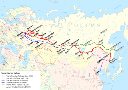
Deutsch: Karte der Transsibirische Eisenbahn. Rot: Streckenführung der Transsibirische Eisenbahn ab 1930. Blau: Streckenführung im Westen vor 1930. Violett: Streckenführung im Osten bis 1916. Schwarz: Südvariante in Sibirien. Grün: Baikal–Amur-Magistrale. Orange: Amur—Yakutsk-Magistrale. Version ohne Namen für Übersetzungen in andere Sprachen. English: Trans-Siberian Railroad map. Red: Route of the Trans-Siberian Railway since 1930. Blue: Route in the west before 1930. Violet: Route in the east until 1916. Black: Southern variant in Siberia. Green: Baikal–Amur Mainline. Orange: Amur–Yakutsk Mainline. Version without city and country names for translations into other languages.
Equidistant conic projection: Central meridian : * E: 100.0° E Standard parallels: * 1: 49.0° N * 2: 59.0° N Projection Code used for QGIS: * +proj=eqdc +lon_0=100e +lat_l=49n +lat_2=59n |
| Date | |
| Source |
Map was created using:
|
| Author |
|
| Permission (Reusing this file) |
|
| Other versions |
|

|
This work is licensed under the Open Database License (summary).Open Database LicenseODbLhttp://opendatacommons.org/licenses/odbl/1.0/true |
File history
Click on a date/time to view the file as it appeared at that time.
| Date/Time | Thumbnail | Dimensions | User | Comment | |
|---|---|---|---|---|---|
| current | 12:18, 16 November 2019 |  | 2,293 × 1,622 (772 KB) | Pechristener (talk | contribs) | == {{int:filedesc}} == {{Information |description={{de|Karte der Transsibirische Eisenbahn. Rot: Streckenführung der Transsibirische Eisenbahn ab 1930. Blau: Streckenführung im Westen vor 1930. Violett: Streckenführung im Osten bis 1916. Schwarz: Südvariante in Sibirien. Grün: Baikal–Amur-Magistrale. Orange: Amur—Yakutsk-Magistrale. Version ohne Namen für Übersetzungen in andere Sprachen.}}{{en|Trans-Siberian Railroad map. Red: Route of the Trans-Siberian Railway since 1930. Blue: Route in th... |
You cannot overwrite this file.
File usage on Commons
The following 8 pages use this file:
- Транссибирская магистраль
- User:Chumwa/OgreBot/Potential transport maps/2019 November 11-20
- User:Chumwa/OgreBot/Public transport information/2019 November 11-20
- User:Chumwa/OgreBot/Transport Maps/2019 November 11-20
- File:Ayam-route-map.png
- File:Karte Transsibirische Eisenbahn 2.svg
- File:Map Trans-Siberian railway.png
- File:Transsib international.svg
File usage on other wikis
The following other wikis use this file:
- Usage on ca.wikipedia.org
- Usage on de.wikipedia.org
Metadata
This file contains additional information such as Exif metadata which may have been added by the digital camera, scanner, or software program used to create or digitize it. If the file has been modified from its original state, some details such as the timestamp may not fully reflect those of the original file. The timestamp is only as accurate as the clock in the camera, and it may be completely wrong.
| Width | 647.2077mm |
|---|---|
| Height | 457.75412mm |

