File:Tropical Depression Cristobal (MODIS 2020-06-09).jpg

Original file (7,282 × 6,725 pixels, file size: 5.72 MB, MIME type: image/jpeg)
Captions
Captions
Summary[edit]
.jpg&action=edit§ion=1)
| Description |
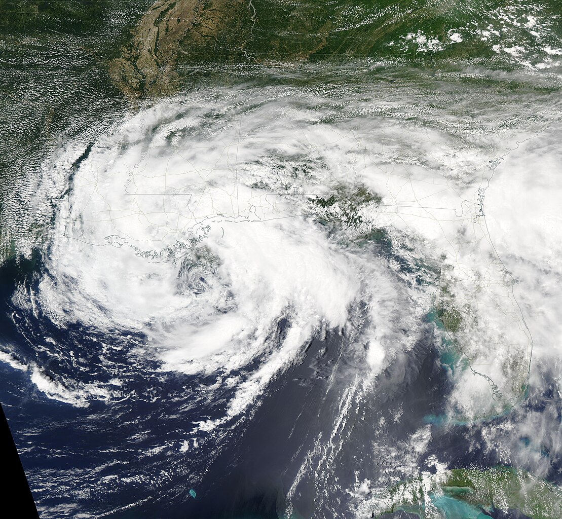
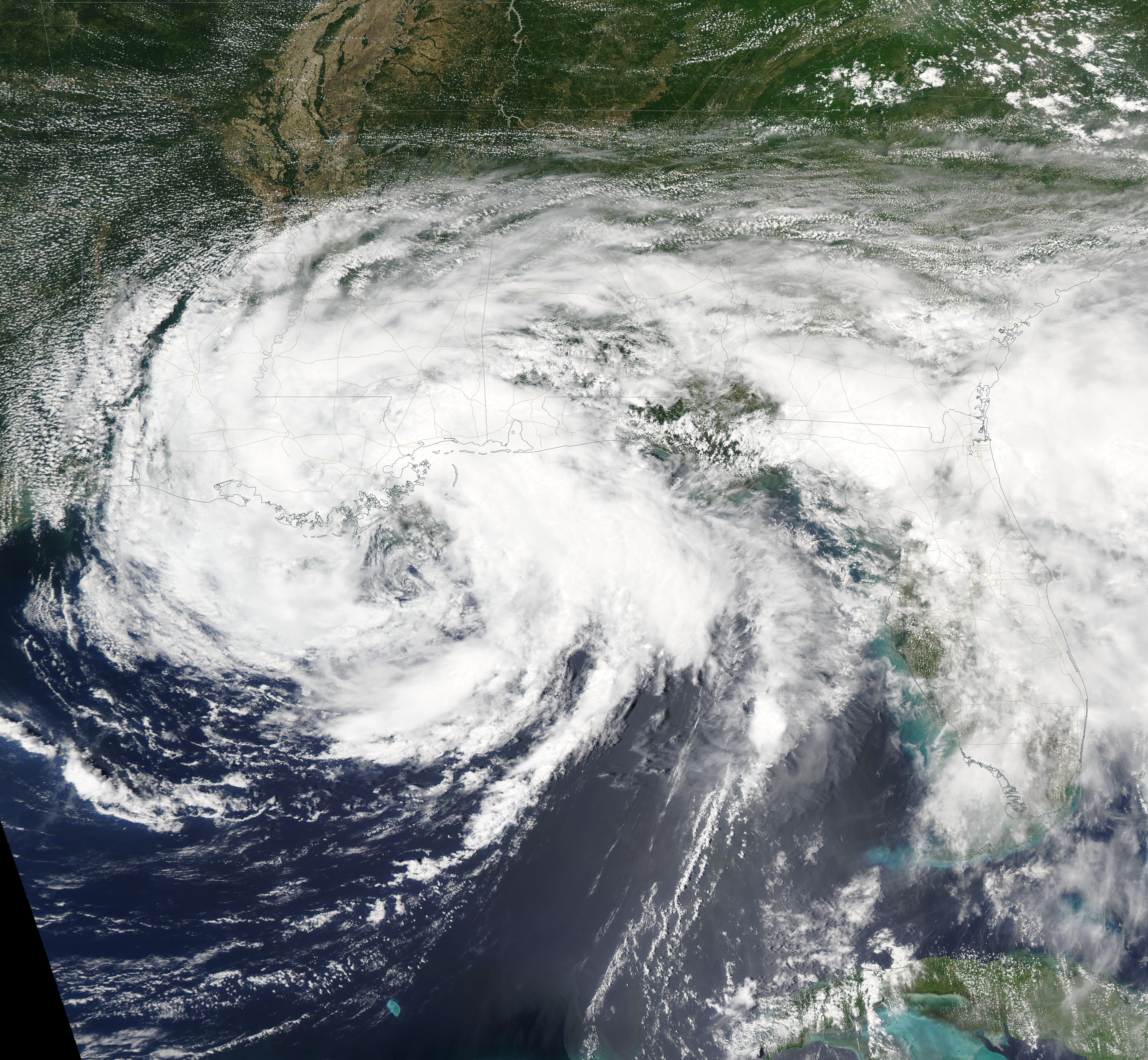
English: Tropical Storm Cristobal made landfall along the coast of southeast Louisiana between the mouth of the Mississippi River and Grand Isle at 6:00 p.m. EDT (2200 UTC) on June 7, 2020. At the storm came ashore, the National Hurricane Center (NHC) estimated it carried maximum sustained winds of 50 mph (85 km/h).
The wind and rain impacted southern Louisiana and parts of Mississippi and Florida. A levee was reported breached in St. Bernard Parish and a levee protecting Grand Isle from hurricane storm surges was damaged in Louisiana. Heavy rain dumped by Cristobal caused closure of several highways and a tornado was spawned in Florida. At 5:00 p.m. EDT (2100 UTC) on June 8, the NHC issued its final advisory on Cristobal. The storm had been downgraded to a depression and was moving across southern Arkansas, with a location about 110 mi (180 km) north of Monroe, Louisiana and 135 mi (220 km) west southwest of Memphis, Tennessee. Maximum sustained winds were estimated at 35 mph (55 km/h). Cristobal was moving north at 18 mph (30 km/h) and expected to spread through the Mississippi Valley into the western Great Lakes during the next couple of days. Flash flood washes are in effect in and near the length of the Mississippi Valley. The Moderate Resolution Imaging Spectroradiometer (MODIS) on board NASA’s Aqua satellite acquired this true-color image of Tropical Storm Cristobal as it moved over southern Louisiana. |
||
| Date | Taken on 7 June 2020 | ||
| Source |
Tropical Depression Cristobal (direct link)
|
||
| Author | MODIS Land Rapid Response Team, NASA GSFC |
| This media is a product of the Aqua mission Credit and attribution belongs to the mission team, if not already specified in the "author" row |
Licensing[edit]
.jpg&action=edit§ion=2)
| This file is in the public domain in the United States because it was solely created by NASA. NASA copyright policy states that "NASA material is not protected by copyright unless noted". (See Template:PD-USGov, NASA copyright policy page or JPL Image Use Policy.) | ||
 |
Warnings:
|
File history
Click on a date/time to view the file as it appeared at that time.
| Date/Time | Thumbnail | Dimensions | User | Comment | |
|---|---|---|---|---|---|
| current | 03:03, 17 February 2024 | | 7,282 × 6,725 (5.72 MB) | OptimusPrimeBot (talk | contribs) | #Spacemedia - Upload of http://modis.gsfc.nasa.gov/gallery/images/image06092020_250m.jpg via Commons:Spacemedia |
You cannot overwrite this file.
File usage on Commons
There are no pages that use this file.
.jpg&oldid=852933553)