File:Typhoon Halong (MODIS 2019-11-05).jpg

Original file (7,917 × 6,671 pixels, file size: 9.62 MB, MIME type: image/jpeg)
Captions
Captions
Summary[edit]
.jpg&action=edit§ion=1)
| Description |
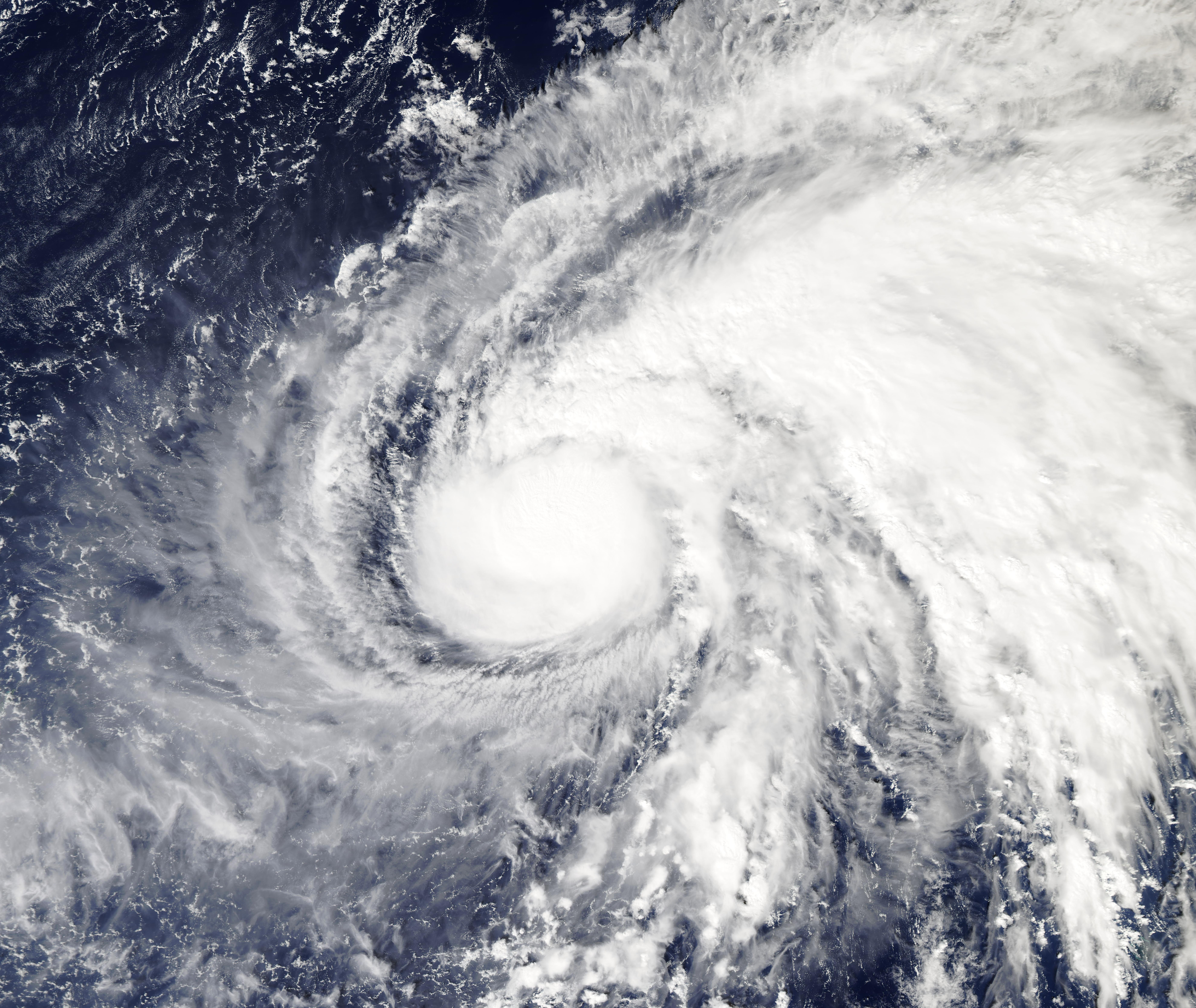
English: Typhoon Halong continued to strengthen over the Northwest Pacific Ocean when NASA’s Aqua satellite passed overhead on November 4, 2019. The Moderate Resolution Imaging Spectroradiometer (MODIS) on board that satellite acquired a true-color image of the storm the same day.
Halong developed on November 2 from a low-pressure area designated as System 99W. The storm consolidated into a tropical storm later that day. On November 3, Halong intensified further and became a typhoon. On November 4 at 4 p.m. EST (2100 UTC), the Joint Typhoon Warning Center (JTWC) reported that Typhoon Halong had maximum sustained winds near 121 mph (195 km/h) or a Category 3 storm on the Saffir-Simpson Hurricane Wind Scale. At that time, Halong had developed an eye as it intensified, and was located about 493 mi (793 km) east-northeast of Saipan. It was tracking northwestward at about 7 mph (11 km/h). According to the JTWC, analysis indicated a favorable environment with low wind shear. This should allow Typhoon Halong to strengthen to a peak maximum wind speed of about 144 mph (232 km/h) by the evening of November 5. After that time, it is expected to turn northward, then to the northeast as it begins to weaken over open ocean. Fortunately, Halong is not expected to interact with land. |
||
| Date | Taken on 4 November 2019 | ||
| Source |
|
||
| Author | MODIS Land Rapid Response Team, NASA GSFC |
| This media is a product of the Aqua mission Credit and attribution belongs to the mission team, if not already specified in the "author" row |
Licensing[edit]
.jpg&action=edit§ion=2)
| This file is in the public domain in the United States because it was solely created by NASA. NASA copyright policy states that "NASA material is not protected by copyright unless noted". (See Template:PD-USGov, NASA copyright policy page or JPL Image Use Policy.) | ||
 |
Warnings:
|
File history
Click on a date/time to view the file as it appeared at that time.
| Date/Time | Thumbnail | Dimensions | User | Comment | |
|---|---|---|---|---|---|
| current | 02:55, 17 February 2024 | | 7,917 × 6,671 (9.62 MB) | OptimusPrimeBot (talk | contribs) | #Spacemedia - Upload of http://modis.gsfc.nasa.gov/gallery/images/image11052019_250m.jpg via Commons:Spacemedia |
You cannot overwrite this file.
File usage on Commons
There are no pages that use this file.
.jpg&oldid=852935462)