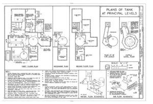
File:U.S. Naval Submarine Base, New London Submarine Escape Training Tank, Albacore and Darter Roads, Groton, New London County, CT HAER CONN,6-GROT,3A- (sheet 1 of 3).png

Original file (14,457 × 9,895 pixels, file size: 7.28 MB, MIME type: image/png)
Captions
Captions
| This image is a JPEG version of the original TIF image at File: U.S. Naval Submarine Base, New London Submarine Escape Training Tank, Albacore and Darter Roads, Groton, New London County, CT HAER CONN,6-GROT,3A- (sheet 1 of 3).tif.
However, any edits to the image should be based on the original TIF version in order to prevent generation loss, and both versions should be updated. Do not make edits based on this version. |
Summary[edit]
| Warning | The original file is very high-resolution. It might not load properly or could cause your browser to freeze when opened at full size. |
|---|
| HAER CONN,6-GROT,3A- (sheet 1 of 3) - U.S. Naval Submarine Base, New London Submarine Escape Training Tank, Albacore and Darter Roads, Groton, New London County, CT | |||||
|---|---|---|---|---|---|
| Photographer |
Related names:
|
||||
| Title |
HAER CONN,6-GROT,3A- (sheet 1 of 3) - U.S. Naval Submarine Base, New London Submarine Escape Training Tank, Albacore and Darter Roads, Groton, New London County, CT |
||||
| Depicted place | Connecticut; New London County; Groton | ||||
| Date | Documentation compiled after 1968 | ||||
| Dimensions | 24 x 36 in. (D size) | ||||
| Current location |
Library of Congress Prints and Photographs Division Washington, D.C. 20540 USA http://hdl.loc.gov/loc.pnp/pp.print |
||||
| Accession number |
HAER CONN,6-GROT,3A- (sheet 1 of 3) |
||||
| Credit line |
|
||||
| Notes |
|
||||
| Source | https://www.loc.gov/pictures/item/ct0564.sheet.00001a | ||||
| Permission (Reusing this file) |
|
||||
| Other versions |
  |
||||
| Camera location | 41° 21′ 00″ N, 72° 04′ 44″ W | View this and other nearby images on: OpenStreetMap |
|---|
File history
Click on a date/time to view the file as it appeared at that time.
| Date/Time | Thumbnail | Dimensions | User | Comment | |
|---|---|---|---|---|---|
| current | 04:44, 17 July 2014 |  | 14,457 × 9,895 (7.28 MB) | Fæ (talk | contribs) | {{Compressed version|file=File:U.S._Naval_Submarine_Base,_New_London_Submarine_Escape_Training_Tank,_Albacore_and_Darter_Roads,_Groton,_New_London_County,_CT_HAER_CONN,6-GROT,3A-_(sheet_1_of_3).tif|thumb=nothumb}} =={{int:filedesc}}== {{Photograph |... |
You cannot overwrite this file.
File usage on Commons
The following 6 pages use this file:
- File:U.S. Naval Submarine Base, New London Submarine Escape Training Tank, Albacore and Darter Roads, Groton, New London County, CT HAER CONN,6-GROT,3A- (sheet 1 of 3).png
- File:U.S. Naval Submarine Base, New London Submarine Escape Training Tank, Albacore and Darter Roads, Groton, New London County, CT HAER CONN,6-GROT,3A- (sheet 1 of 3).tif
- File:U.S. Naval Submarine Base, New London Submarine Escape Training Tank, Albacore and Darter Roads, Groton, New London County, CT HAER CONN,6-GROT,3A- (sheet 2 of 3).png
- File:U.S. Naval Submarine Base, New London Submarine Escape Training Tank, Albacore and Darter Roads, Groton, New London County, CT HAER CONN,6-GROT,3A- (sheet 2 of 3).tif
- File:U.S. Naval Submarine Base, New London Submarine Escape Training Tank, Albacore and Darter Roads, Groton, New London County, CT HAER CONN,6-GROT,3A- (sheet 3 of 3).png
- File:U.S. Naval Submarine Base, New London Submarine Escape Training Tank, Albacore and Darter Roads, Groton, New London County, CT HAER CONN,6-GROT,3A- (sheet 3 of 3).tif
Metadata
This file contains additional information such as Exif metadata which may have been added by the digital camera, scanner, or software program used to create or digitize it. If the file has been modified from its original state, some details such as the timestamp may not fully reflect those of the original file. The timestamp is only as accurate as the clock in the camera, and it may be completely wrong.
| Horizontal resolution | 28.35 dpc |
|---|---|
| Vertical resolution | 28.35 dpc |

