File:United Nations geographical subregions en.svg
Jump to navigation
Jump to search

Size of this PNG preview of this SVG file: 800 × 406 pixels. Other resolutions: 320 × 162 pixels | 640 × 325 pixels | 1,024 × 520 pixels | 1,280 × 650 pixels | 2,560 × 1,300 pixels | 2,754 × 1,398 pixels.
Original file (SVG file, nominally 2,754 × 1,398 pixels, file size: 1.18 MB)
Captions
Captions
Add a one-line explanation of what this file represents
Summary
[edit]| Description |
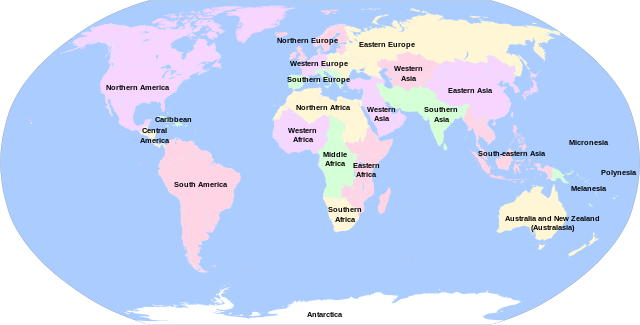
English: United Nations geographical subregions. Labelled in English. Own work, using File:BlankMap-World6.svg. Information according to File:United Nations geographical subregions.png and http://unstats.un.org/unsd/methods/m49/m49regin.htm. Deutsch: Geographische Unterregionen laut Einteilung der Vereinigten Nationen. Beschriftung auf Englisch. Eigene Arbeit unter Benutzung der Datei File:BlankMap-World6.svg. Information laut File:United Nations geographical subregions.png und http://unstats.un.org/unsd/methods/m49/m49regin.htm. Esperanto: eografiaj subregionoj laŭ Unuiĝintaj Nacioj. Priskribo en Englisch. Propra laboro, uzante la dosieron File:BlankMap-World6.svg. Informoj laŭ File:United Nations geographical subregions.png kaj http://unstats.un.org/unsd/methods/m49/m49regin.htm. |
| Date | |
| Source | Own work |
| Author | T.seppelt |
| Other versions |
|


| This is a retouched picture, which means that it has been digitally altered from its original version. Modifications: Translated to English. The original can be viewed here: Geografiaj subregionoj laŭ Unuiĝintaj Nacioj eo.svg:
|

|
A raster version of this image is available. It should be used in place of this vector image when superior.
File:United Nations geographical subregions en.svg → File:United Nations geographical subregions.png
In general, it is better to use a good SVG version. |
Licensing
[edit]
I, the copyright holder of this work, hereby publish it under the following license:
This file is licensed under the Creative Commons Attribution-Share Alike 4.0 International license.
- You are free:
- to share – to copy, distribute and transmit the work
- to remix – to adapt the work
- Under the following conditions:
- attribution – You must give appropriate credit, provide a link to the license, and indicate if changes were made. You may do so in any reasonable manner, but not in any way that suggests the licensor endorses you or your use.
- share alike – If you remix, transform, or build upon the material, you must distribute your contributions under the same or compatible license as the original.
File history
Click on a date/time to view the file as it appeared at that time.
| Date/Time | Thumbnail | Dimensions | User | Comment | |
|---|---|---|---|---|---|
| current | 23:09, 13 August 2023 | | 2,754 × 1,398 (1.18 MB) | 職員室 (talk | contribs) | Reverted to version as of 12:06, 13 June 2021 (UTC) to local file |
| 13:04, 6 August 2023 |  | 2,754 × 1,398 (1.14 MB) | 職員室 (talk | contribs) | File uploaded using svgtranslate tool (https://svgtranslate.toolforge.org/). Added translation for ja. | |
| 12:06, 13 June 2021 |  | 2,754 × 1,398 (1.18 MB) | Sbb1413 (talk | contribs) | Updated | |
| 08:57, 3 October 2014 |  | 940 × 477 (1.67 MB) | T.seppelt (talk | contribs) | User created page with UploadWizard |
You cannot overwrite this file.
File usage on Commons
The following 15 pages use this file:
- User:Magog the Ogre/Multilingual legend/2021 June 11-20
- User:Magog the Ogre/Multilingual legend/2023 August 1-10
- User:Magog the Ogre/Multilingual legend/2023 August 11-16
- Commons:Territorial division of the World
- File:Geografiaj subregionoj laŭ Unuiĝintaj Nacioj eo.svg
- File:Geografiaj subregionoj laŭ Unuiĝintaj Nacioj hr.svg
- File:UNESCO subregions en.svg
- File:United Nations geographical subregions.png
- File:United Nations geographical subregions de.svg
- File:United Nations geographical subregions en.svg
- File:United Nations geographical subregions ja.svg
- File:United Nations geographical subregions lv.svg
- File:United Nations geographical subregions zh.svg
- File:Географски подрегиони на светот според ООН.svg
- Category:United Nations subregions
File usage on other wikis
The following other wikis use this file:
- Usage on ast.wikipedia.org
- Usage on bg.wikipedia.org
- Usage on bs.wikipedia.org
- Usage on ca.wikipedia.org
- Usage on cs.wikipedia.org
- Usage on da.wikipedia.org
- Usage on en.wikipedia.org
- Usage on es.wikipedia.org
- Usage on gd.wikipedia.org
- Usage on hy.wikipedia.org
- Usage on id.wikipedia.org
- Usage on ilo.wikipedia.org
- Usage on ka.wikipedia.org
- Usage on kk.wikipedia.org
- Usage on kn.wikipedia.org
- Usage on ko.wikipedia.org
- Usage on la.wikipedia.org
- Usage on my.wikipedia.org
- Usage on no.wikipedia.org
- Usage on oc.wikipedia.org
- Usage on sr.wikipedia.org
- Usage on www.wikidata.org