File:Västergötland och Dals bon.xcf

Original file (2,146 × 2,628 pixels, file size: 742 KB, MIME type: image/x-xcf)
Captions
Captions
|
|
Summary[edit]
| Description |
English: Map showing the boundaries of the "Bon" in the provinces of Västergötland and Dalsland, Sweden.
Svenska: Karta visande Västergötland med Dalslands bon.
|
| Date | (UTC) |
| Source | |
| Author |
|
| This is a retouched picture, which means that it has been digitally altered from its original version. Modifications: added context. The original can be viewed here: Härader i Västergötland och Dalsland.svg:
|
| I, the copyright holder of this work, release this work into the public domain. This applies worldwide. In some countries this may not be legally possible; if so: I grant anyone the right to use this work for any purpose, without any conditions, unless such conditions are required by law. |
Original upload log[edit]
This image is a derivative work of the following images:
- File:Härader_i_Västergötland_och_Dalsland.svg licensed with PD-self
- File:File:Härader Västergötland med Dal.svg licensed with PD-self
Uploaded with derivativeFX
Licensing[edit]

|
The copyright holder of this work allows anyone to use it for any purpose including unrestricted redistribution, commercial use, and modification.
Usage notes:
|
File history
Click on a date/time to view the file as it appeared at that time.
| Date/Time | Thumbnail | Dimensions | User | Comment | |
|---|---|---|---|---|---|
| current | 13:09, 8 October 2016 | 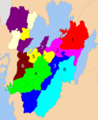 | 2,146 × 2,628 (742 KB) | Andejons (talk | contribs) | {{Information |Description={{en|1=Map showing the boundaries of the "Bon" in the provinces of Västergötland and Dalsland, Sweden.}} {{sv|1=Karta visande Västergötland med Dalslands bon.}} |Source=*[[:File:Härader Västergötland med Dal.svg|Härad... |
You cannot overwrite this file.
File usage on Commons
There are no pages that use this file.
File usage on other wikis
The following other wikis use this file:
- Usage on sv.wikipedia.org