File:V-Weapon sites F B.png
Original file (1,588 × 1,046 pixels, file size: 2.6 MB, MIME type: image/png)
Captions
Captions
Summary[edit]
| Description |
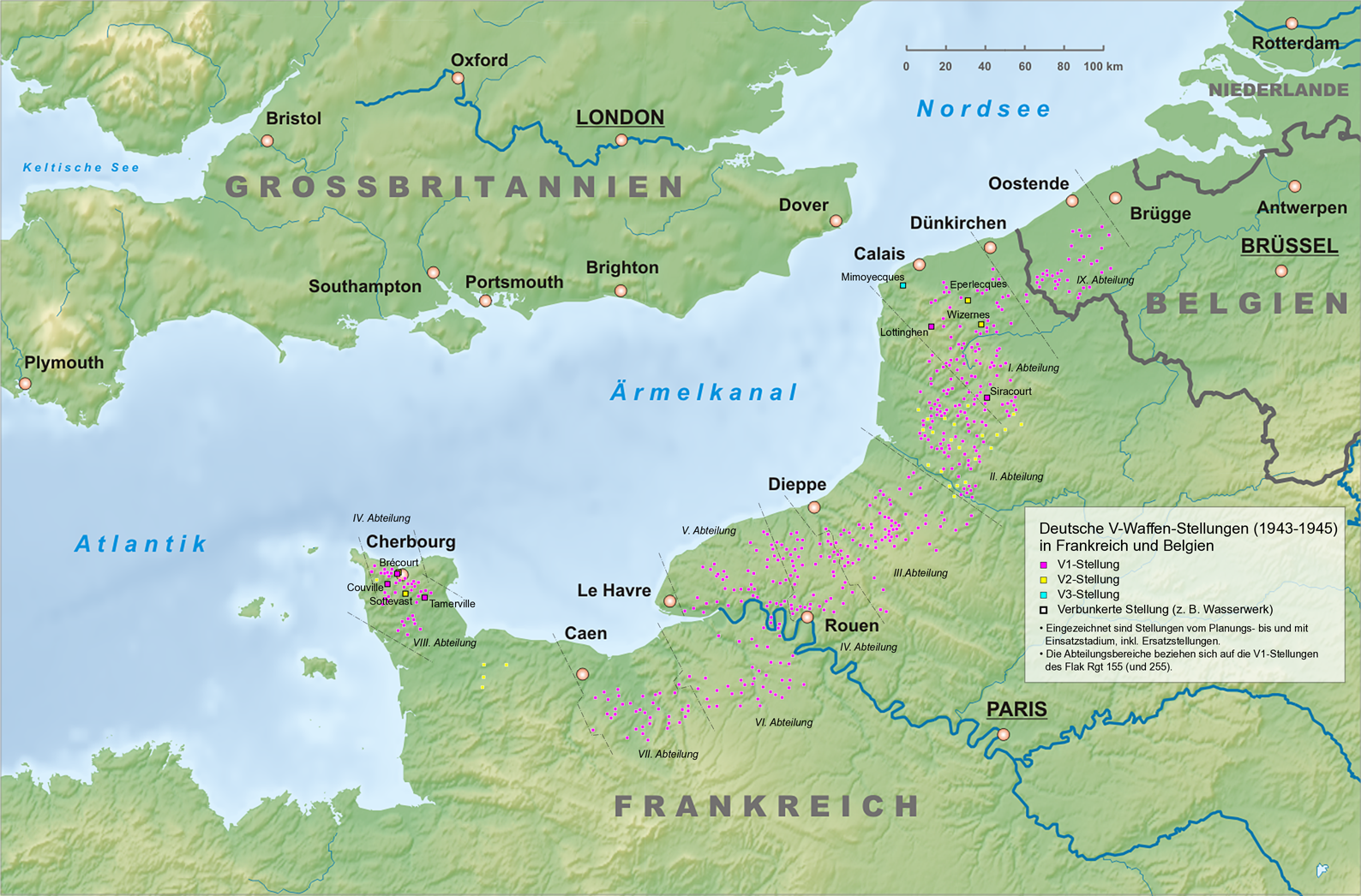
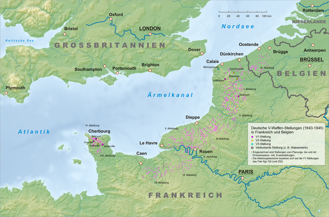
English:
Map of the German V-Weapon sites In France and Belgium. The map includes deployment sites of V-1 V-2 and HDP (V-3). Deutsch: Karte der deutschen V-Waffen Standorte in Frankreich und Belgien. Die Karte beinhaltet Einsatzstandorte von V1, V2 und HDP (V3). |
| Date | |
| Source | Own work |
| Author | Хрюша |
| Other versions |
 |
Literatur[edit]
- Karsten Porezag: Geheime Kommandosache; Geschichte der "V-Waffen" und geheimen Militäraktionen des Zweiten Weltkrieges an Lahn, Dill und im Westerwald; Dokumentation. Wetzlardruck, Wetzlar 1997, ISBN 3-926617-20-9.
- Walter Dornberger: Peenemünde - Die Geschichte der V-Waffen. Ullstein Berlin 2008, ISBN 978-3-548-33119-5.
- Wolfgang Gückelhorn/Detlev Paul: V1 – „Eifelschreck“ Abschüsse, Abstürze und Einschläge der fliegenden Bombe aus der Eifel und dem Rechtsrheinischen 1944/45; Eine Dokumentation. Helios-Verlag, Aachen 2004, ISBN 3-933608-94-5.
- Wolfgang Gückelhorn/Detlev Paul: V2 gefrorene Blitze Einsatzgeschichte der V2 aus Eifel, Hunsrück und Westerwald 1944/45; Eine Dokumentation. Helios-Verlag, Aachen 2007, ISBN 978-3-938208-43-4.
- Laurent Bailleul: Les Sites V1 en Picardie. Autoéditeur, Hazebrouck 2006, ISBN 2-9515840-1-6.
- Steven J. Zaloga: German V-Weapon Sites 1943-45. Osprey Publishing Ltd, Oxford 2007, ISBN 978-1-84603-247-9.
Licensing[edit]
- You are free:
- to share – to copy, distribute and transmit the work
- to remix – to adapt the work
- Under the following conditions:
- attribution – You must give appropriate credit, provide a link to the license, and indicate if changes were made. You may do so in any reasonable manner, but not in any way that suggests the licensor endorses you or your use.
- share alike – If you remix, transform, or build upon the material, you must distribute your contributions under the same or compatible license as the original.

|
This media was created by Chriusha/Хрюша.
|
| Attribution (required by the license) | |
| Additional information: | |
|
The mentioned licence on my media is exclusively valid for the version and resolution up to the shown on Wikimedia Commons. Any other version of the shown media or higher resolution optionally available on another website is not included in this licencing and not allowed for free use. | |
|
The values of focal length and aperture in the metadata need to be read with precaution! |
File history
Click on a date/time to view the file as it appeared at that time.
| Date/Time | Thumbnail | Dimensions | User | Comment | |
|---|---|---|---|---|---|
| current | 21:15, 18 March 2010 | | 1,588 × 1,046 (2.6 MB) | Chriusha (talk | contribs) | == {{int:filedesc}} == {{Information |Description={{en}}Map of the German V-Weapon sites In France and Belgium. The map includes deployment sites of V1 V2 and V3. {{de}}Karte der deutschen V-Waffen Standorte in Frankreich und Belgien. Die Karte beinhaltet |
You cannot overwrite this file.
File usage on Commons
The following 3 pages use this file:
File usage on other wikis
The following other wikis use this file:
- Usage on pt.wikipedia.org
- Usage on uk.wikipedia.org