File:Venus clouds Galileo PIA00221.jpg
Jump to navigation
Jump to search

No higher resolution available.
Venus_clouds_Galileo_PIA00221.jpg (600 × 310 pixels, file size: 15 KB, MIME type: image/jpeg)
Captions
Captions
Add a one-line explanation of what this file represents
Summary[edit]
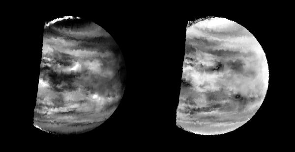
| Description | These images are two versions of a near-infrared map of lower-level clouds on the night side of Venus, obtained by the Near Infrared Mapping Spectrometer aboard the Galileo spacecraft as it approached the planet February 10, 1990. Taken from an altitude of about 60,000 miles above the planet, at an infrared wavelength of 2.3 microns (about three times the longest wavelength visible to the human eye) the map shows the turbulent, cloudy middle atmosphere some 30-33 miles above the surface, 6-10 miles below the visible cloudtops. The image to the left shows the radiant heat from the lower atmosphere (about 400 degrees Fahrenheit) shining through the sulfuric acid clouds, which appear as much as 10 times darker than the bright gaps between clouds. This cloud layer is at about -30 degrees Fahrenheit, at a pressure about 1/2 Earth's atmospheric pressure. About 2/3 of the dark hemisphere is visible, centered on longitude 350 West, with bright slivers of daylit high clouds visible at top and bottom left. The right image, a modified negative, represents what scientists believe would be the visual appearance of this mid-level cloud deck in daylight, with the clouds reflecting sunlight instead of blocking out infrared from the hot planet and lower atmosphere. Near the equator, the clouds appear fluffy and blocky; farther north, they are stretched out into East-West filaments by winds estimated at more than 150 mph, while the poles are capped by thick clouds at this altitude. The Near Infrared Mapping Spectrometer (NIMS) on the Galileo spacecraft is a combined mapping (imaging) and spectral instrument. It can sense 408 contiguous wavelengths from 0.7 microns (deep red) to 5.2 microns, and can construct a map or image by mechanical scanning. It can spectroscopically analyze atmospheres and surfaces and construct thermal and chemical maps. Designed and operated by scientists and engineers at the Jet Propulsion Laboratory, NIMS involves 15 scientists in the U.S., England, and France. The Galileo Project is managed for NASA's Office of Space Science and Applications by JPL; its mission is to study the planet Jupiter and its satellites and magnetosphere after multiple gravity-assist flybys at Venus and the Earth. |
| Date | |
| Source | |
| Author | NASA |
This image or video was catalogued by Jet Propulsion Laboratory of the United States National Aeronautics and Space Administration (NASA) under Photo ID: PIA00221. This tag does not indicate the copyright status of the attached work. A normal copyright tag is still required. See Commons:Licensing. Other languages:
|
Licensing[edit]
| This file is in the public domain in the United States because it was solely created by NASA. NASA copyright policy states that "NASA material is not protected by copyright unless noted". (See Template:PD-USGov, NASA copyright policy page or JPL Image Use Policy.) | ||
 |
Warnings:
|
File history
Click on a date/time to view the file as it appeared at that time.
| Date/Time | Thumbnail | Dimensions | User | Comment | |
|---|---|---|---|---|---|
| current | 13:28, 11 January 2008 | | 600 × 310 (15 KB) | Ruslik0 (talk | contribs) | {{Information |Description=These images are two versions of a near-infrared map of lower-level clouds on the night side of Venus, obtained by the Near Infrared Mapping Spectrometer aboard the Galileo spacecraft as it approached the planet February 10, 199 |
You cannot overwrite this file.
File usage on Commons
There are no pages that use this file.
File usage on other wikis
The following other wikis use this file:
- Usage on fr.wikipedia.org