File:Vlaams GewestLocatie.svg
Jump to navigation
Jump to search

Size of this PNG preview of this SVG file: 307 × 251 pixels. Other resolutions: 294 × 240 pixels | 587 × 480 pixels | 939 × 768 pixels | 1,253 × 1,024 pixels | 2,505 × 2,048 pixels.
Original file (SVG file, nominally 307 × 251 pixels, file size: 68 KB)
Captions
Captions
Add a one-line explanation of what this file represents
Summary[edit]
| Description |
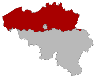
Français : Carte avec la Flandre en rouge plein |
| Date | |
| Source | Own work |
| Author | Moi |

|
This file has been superseded by Flemish Region in Belgium.svg. It is recommended to use the other file. Please note that deleting superseded images requires consent.
|

|
Licensing[edit]
I, the copyright holder of this work, hereby publish it under the following license:
This file is licensed under the Creative Commons Attribution-Share Alike 3.0 Unported license.
- You are free:
- to share – to copy, distribute and transmit the work
- to remix – to adapt the work
- Under the following conditions:
- attribution – You must give appropriate credit, provide a link to the license, and indicate if changes were made. You may do so in any reasonable manner, but not in any way that suggests the licensor endorses you or your use.
- share alike – If you remix, transform, or build upon the material, you must distribute your contributions under the same or compatible license as the original.
File history
Click on a date/time to view the file as it appeared at that time.
| Date/Time | Thumbnail | Dimensions | User | Comment | |
|---|---|---|---|---|---|
| current | 07:41, 11 October 2008 | | 307 × 251 (68 KB) | Vascer (talk | contribs) | {{Information |Description={{fr|1=Carte avec la Flandre en rouge plein}} |Source=Fait moi-même |Author=Moi |Date=~~~~~ |Permission= |other_versions= }} <!--{{ImageUpload|full}}--> Category:Maps of Flanders |
You cannot overwrite this file.
File usage on Commons
The following page uses this file:
File usage on other wikis
The following other wikis use this file:
- Usage on cs.wikipedia.org
- Usage on de.wikipedia.org
- Usage on eu.wikipedia.org
- Usage on fr.wikipedia.org