File:Vorder-Asien. LOC 2013593006.jpg
Jump to navigation
Jump to search

Size of this preview: 748 × 600 pixels. Other resolutions: 300 × 240 pixels | 599 × 480 pixels | 958 × 768 pixels | 1,278 × 1,024 pixels | 2,555 × 2,048 pixels | 7,120 × 5,707 pixels.
Original file (7,120 × 5,707 pixels, file size: 5.56 MB, MIME type: image/jpeg)
Captions
Captions
Add a one-line explanation of what this file represents
Summary[edit]
| Description |
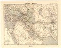
English: Shows the boundaries of the Ottoman and Russian empires, British colonies in India and the extents of the Imam of Maskat territory--all in different border colors. Relief shown by hachures. "Terrain gestochen von C. Seitz 1855. Situation und schrift gestochen von C. F. Wolff." "H. Kiepert's Neuer handatlas No. 28. Berlin, Bei Dietrich Reimer." Includes list of topographic terms in Turkish, Arabic and Persian. Available also through the Library of Congress Web site as a raster image. |
||
| Title | Vorder-Asien. | ||
| Shelf ID | G7420 1855 .D5 | ||
| Date | |||
| Source | https://www.loc.gov/item/2013593006/ | ||
| Author | Dietrich Reimer Verlag (Berlin, Germany); Contained In (Work): Kiepert, Heinrich | ||
| Permission (Reusing this file) |
|
||
| Other versions |
|
||
| Location | Middle East | ||
| Part of | American Memory · General Maps · Catalog · Geography And Map Division | ||
| Subject | Maps · Middle East |

Licensing[edit]
|
This is a faithful photographic reproduction of a two-dimensional, public domain work of art. The work of art itself is in the public domain for the following reason:
The official position taken by the Wikimedia Foundation is that "faithful reproductions of two-dimensional public domain works of art are public domain".
This photographic reproduction is therefore also considered to be in the public domain in the United States. In other jurisdictions, re-use of this content may be restricted; see Reuse of PD-Art photographs for details. | ||||
File history
Click on a date/time to view the file as it appeared at that time.
| Date/Time | Thumbnail | Dimensions | User | Comment | |
|---|---|---|---|---|---|
| current | 21:03, 24 August 2018 | | 7,120 × 5,707 (5.56 MB) | Fæ (talk | contribs) | LOC Maps https://www.loc.gov/item/2013593006/ #5548 |
You cannot overwrite this file.
File usage on Commons
The following page uses this file: