File:WheatYield.png
Jump to navigation
Jump to search
Size of this preview: 800 × 489 pixels. Other resolutions: 320 × 196 pixels | 640 × 391 pixels | 1,024 × 626 pixels | 1,476 × 902 pixels.
Original file (1,476 × 902 pixels, file size: 535 KB, MIME type: image/png)
Captions
Captions
Add a one-line explanation of what this file represents
Summary[edit]
| Description |
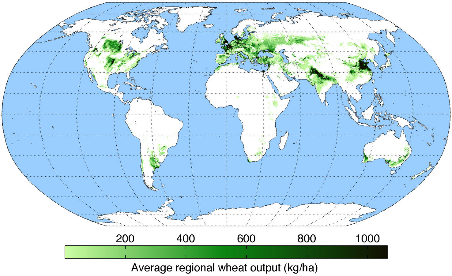
English: Map of wheat production (average percentage of land used for its production times average yield in each grid cell) across the world compiled by the University of Minnesota Institute on the Environment with data from: Monfreda, C., N. Ramankutty, and J.A. Foley. 2008. Farming the planet: 2. Geographic distribution of crop areas, yields, physiological types, and net primary production in the year 2000. Global Biogeochemical Cycles 22: GB1022 |
| Date | |
| Source | Own work |
| Author | AndrewMT |
Licensing[edit]
I, the copyright holder of this work, hereby publish it under the following license:
This file is licensed under the Creative Commons Attribution-Share Alike 3.0 Unported license.
- You are free:
- to share – to copy, distribute and transmit the work
- to remix – to adapt the work
- Under the following conditions:
- attribution – You must give appropriate credit, provide a link to the license, and indicate if changes were made. You may do so in any reasonable manner, but not in any way that suggests the licensor endorses you or your use.
- share alike – If you remix, transform, or build upon the material, you must distribute your contributions under the same or compatible license as the original.
File history
Click on a date/time to view the file as it appeared at that time.
| Date/Time | Thumbnail | Dimensions | User | Comment | |
|---|---|---|---|---|---|
| current | 11:52, 7 October 2023 | | 1,476 × 902 (535 KB) | Chiswick Chap (talk | contribs) | Cropped deadspace |
| 19:27, 26 May 2010 |  | 1,600 × 960 (540 KB) | AndrewMT (talk | contribs) | Bigger resolution | |
| 20:30, 3 March 2010 |  | 800 × 500 (215 KB) | AndrewMT (talk | contribs) | {{Information |Description={{en|1=Map of wheat yield across the world (kg/ha) compiled by the University of Minnesota Institute on the Environment}} |Source=Own work |Author=AndrewMT |Date=2010-03-03 |Permission= |other_versions= }} |
You cannot overwrite this file.
File usage on Commons
The following page uses this file:
File usage on other wikis
The following other wikis use this file:
- Usage on ar.wikipedia.org
- Usage on arz.wikipedia.org
- Usage on be-tarask.wikipedia.org
- Usage on bn.wikipedia.org
- Usage on bs.wikipedia.org
- Usage on ckb.wikipedia.org
- Usage on de.wikipedia.org
- Usage on en.wikipedia.org
- Usage on es.wikipedia.org
- Usage on eu.wikipedia.org
- Usage on fa.wikipedia.org
- Usage on fr.wikipedia.org
- Usage on he.wikipedia.org
- Usage on hi.wikipedia.org
- Usage on hy.wikipedia.org
- Usage on it.wikipedia.org
- Usage on ja.wikipedia.org
- Usage on kn.wikipedia.org
- Usage on ko.wikipedia.org
- Usage on kw.wikipedia.org
- Usage on mk.wikipedia.org
- Usage on mzn.wikipedia.org
- Usage on oc.wikipedia.org
- Usage on sa.wikipedia.org
- Usage on sr.wikipedia.org
- Usage on ta.wikipedia.org
- Usage on th.wikipedia.org
- Usage on tr.wikipedia.org
- Usage on uk.wikipedia.org
- Usage on zh.wikipedia.org
View more global usage of this file.