File:World in 2000 BC.svg
Jump to navigation
Jump to search

Size of this PNG preview of this SVG file: 800 × 397 pixels. Other resolutions: 320 × 159 pixels | 640 × 318 pixels | 1,024 × 508 pixels | 1,280 × 635 pixels | 2,560 × 1,271 pixels | 4,500 × 2,234 pixels.
Original file (SVG file, nominally 4,500 × 2,234 pixels, file size: 847 KB)
Captions
Captions
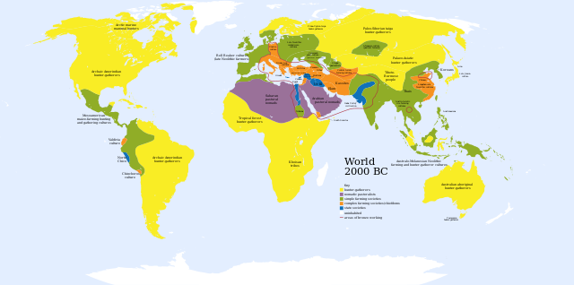
Map of societies, 2000 BCE. Colour coded by cultural stage. Includes simple farming societies; complex farming societies (Near East, Europe, China, Andes); state societies (Fertile Crescent, Egypt, Indus, Crete, Caral/Norte Chico).
Edit it
Summary[edit]
| Description |
English: A map of the world, circa 2000 BC
Ελληνικά: Πολιτισμοί το 2000 π.Χ.
Français : Une carte du monde aux environs de 2000 av. J.-C. |
| Date | |
| Source | Based on Image:World_2000_BCE.png by User:Briangotts |
| Author | User:Mr.absurd |
| Other versions |
 in Greek in Greek |
| SVG development | This diagram was created with Inkscape. This diagram is translated using SVG switch elements: all translations are stored in the same file. |
| Maps of world history | |
| BC | |
|
| |
| AD |
1 · 50 · 100 · 200 · 250 · 300 · 400 · 500 · 700 · 750 · 820 · 900 · 1200 · 1500 · 1556 · 1648 · 1700 · 1750 · 1815 · 1859 · 1871 · 1914 · 1935 · 1954 · 1989 · 2000 · |
|
Maps of colonization history | |
|
see also: Eastern Hemisphere only maps template (1300BC-1500AD) | |
| (this template: · view · discuss ) | |
.jpg)
._LOC_2001620596.jpg)
Key[edit]
uninhabited
- Red outline indicates areas of bronze working, c. 2000 BCE.
Licensing[edit]
| I, the copyright holder of this work, release this work into the public domain. This applies worldwide. In some countries this may not be legally possible; if so: I grant anyone the right to use this work for any purpose, without any conditions, unless such conditions are required by law. |
File history
Click on a date/time to view the file as it appeared at that time.
| Date/Time | Thumbnail | Dimensions | User | Comment | |
|---|---|---|---|---|---|
| current | 01:36, 30 November 2023 | | 4,500 × 2,234 (847 KB) | Blkgardner (talk | contribs) | Reverted to version as of 09:55, 24 January 2022 (UTC) Punt's location is disputed, and it wasn't a "state society" |
| 12:31, 28 September 2023 |  | 4,500 × 2,234 (876 KB) | Notradeuussrs (talk | contribs) | added Punt | |
| 09:55, 24 January 2022 |  | 4,500 × 2,234 (847 KB) | Scratchinghead (talk | contribs) | Reverted to version as of 12:48, 3 May 2018 (UTC) | |
| 15:00, 3 May 2018 |  | 4,500 × 2,234 (862 KB) | LeBret (talk | contribs) | Greek translation added (from World 2000 BC EL.svg author: George Tsiagalakis | |
| 12:48, 3 May 2018 |  | 4,500 × 2,234 (847 KB) | LeBret (talk | contribs) | 1) fix the civilisation of Indus valley (it's a state society, not nomadic pastoralists, as we can see in the original png file) 2) SVG is now multi-lingual (french translation added) | |
| 17:43, 20 March 2009 |  | 4,500 × 2,234 (814 KB) | Huhsunqu (talk | contribs) | Norte Chico | |
| 03:31, 23 October 2007 |  | 4,500 × 2,234 (813 KB) | Mr. Absurd (talk | contribs) | == Summary == {{Information |Description=A map of the world, circa 2000 BC |Source=Based on Image:World_2000_BCE.png by User:Briangotts |Date=October 22, 2007 |Author=User:Mr.absurd |Permission= |other_versions= }} | |
| 03:13, 23 October 2007 |  | 4,500 × 2,234 (1.46 MB) | Mr. Absurd (talk | contribs) | == Summary == {{Information |Description=A map of the world, circa 2000 BC |Source=Based on Image:World_2000_BCE.png by User:Briangotts |Date=October 22, 2007 |Author=User:Mr.absurd |Permission= |other_versions= }} [[Category:SVG_maps_of_th | |
| 02:51, 23 October 2007 |  | 4,500 × 2,234 (1.45 MB) | Mr. Absurd (talk | contribs) | == Summary == {{Information |Description=A map of the world, circa 2000 BC |Source=Based on Image:World_2000_BCE.png by User:Briangotts |Date=October 22, 2007 |Author=User:Mr.absurd |Permission= |other_versions= }} | |
| 02:25, 23 October 2007 |  | 5,365 × 2,796 (1.27 MB) | Mr. Absurd (talk | contribs) | {{Information |Description=A map of the world, circa 2000 BC |Source=Based on Image:World_2000_BCE.png by User:Briangotts |Date=October 22, 2007 |Author=User:Mr.absurd |Permission= |other_versions= }} |
You cannot overwrite this file.
File usage on Commons
The following 12 pages use this file:
- Atlas of prehistory
- Atlas of world history
- User:Magog the Ogre/Multilingual legend/2022 January 21-31
- User:Magog the Ogre/Multilingual legend/2023 November 26-30
- User:Magog the Ogre/Multilingual legend/2023 September 26-30
- File:Eurasia & Northern Africa 2000 BC.jpg
- File:World 2000 BC.svg (file redirect)
- File:World 2000 BCE.png
- File:World 2000 BC EL.svg
File usage on other wikis
The following other wikis use this file:
- Usage on ar.wikipedia.org
- Usage on ary.wikipedia.org
- Usage on de.wikipedia.org
- Usage on el.wikipedia.org
- Usage on en.wikipedia.org
- Usage on fr.wikipedia.org
- Usage on he.wikipedia.org
- Usage on hu.wikipedia.org
- Usage on io.wikipedia.org
- Usage on it.wikipedia.org
- Usage on li.wikipedia.org
- Usage on ml.wikipedia.org
- Usage on no.wikipedia.org
- Usage on oc.wikipedia.org
- Usage on pl.wikipedia.org
- Usage on pt.wikipedia.org
- Usage on ru.wikipedia.org
- Usage on sv.wikipedia.org
- Usage on sw.wikipedia.org
- Usage on uk.wikipedia.org
- Usage on zh.wikipedia.org