File:Zambia-regions-map.svg
Jump to navigation
Jump to search

Size of this PNG preview of this SVG file: 609 × 600 pixels. Other resolutions: 244 × 240 pixels | 488 × 480 pixels | 780 × 768 pixels | 1,040 × 1,024 pixels | 2,080 × 2,048 pixels | 643 × 633 pixels.
Original file (SVG file, nominally 643 × 633 pixels, file size: 1.95 MB)
Captions
Captions
Add a one-line explanation of what this file represents
Summary[edit]
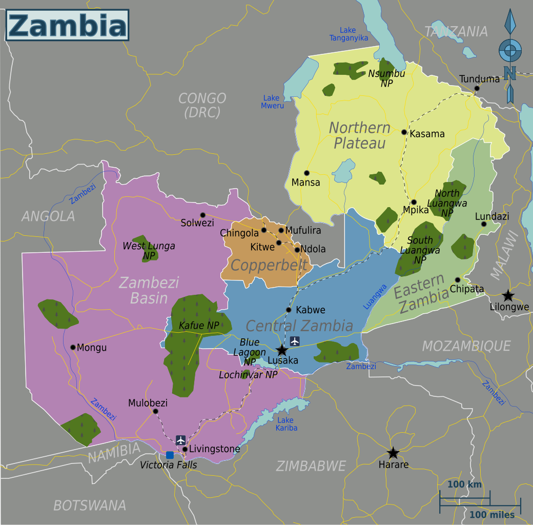
| Description |
Map of Zambia (SVG). |
| Date | |
| Source | Own work based on Perry Castañeda Library Map Collection - University of Texas Libraries |
| Author | Globe-trotter |
| Other versions | Zambia-regions-map.png |
Licensing[edit]
This file is licensed under the Creative Commons Attribution-Share Alike 3.0 Unported license.
- You are free:
- to share – to copy, distribute and transmit the work
- to remix – to adapt the work
- Under the following conditions:
- attribution – You must give appropriate credit, provide a link to the license, and indicate if changes were made. You may do so in any reasonable manner, but not in any way that suggests the licensor endorses you or your use.
- share alike – If you remix, transform, or build upon the material, you must distribute your contributions under the same or compatible license as the original.
Original upload log[edit]
| This file was imported from Wikivoyage WTS. |
The original description page was here. All following user names refer to wts.wikivoyage-old.
- 2010-01-27 01:36 (WT-shared) Globe-trotter[dead link] 409×329 (2079130 bytes) {{Imagecredit|credit=Globe-trotter, based on Perry Castañeda - University of Texas Library Map Collection [http://www.lib.utexas.edu/maps/z (Import from wikitravel.org/shared)
- 2010-01-27 16:07 (WT-shared) Globe-trotter[dead link] 409×329 (2092993 bytes) added railroads, changed regions to government borders, added solwezi and a town in the south (Import from wikitravel.org/shared)
- 2012-10-31 14:01 Globe-trotter[dead link] 643×633 (2042574 bytes) major improvement of the map
File history
Click on a date/time to view the file as it appeared at that time.
| Date/Time | Thumbnail | Dimensions | User | Comment | |
|---|---|---|---|---|---|
| current | 15:56, 20 November 2012 | | 643 × 633 (1.95 MB) | OgreBot (talk | contribs) | (BOT): Reverting to most recent version before archival |
| 15:56, 20 November 2012 |  | 409 × 329 (2 MB) | OgreBot (talk | contribs) | (BOT): Uploading old version of file from wts.wikivoyage; originally uploaded on 2010-01-27 16:07:20 by (WT-shared) Globe-trotter | |
| 15:56, 20 November 2012 |  | 409 × 329 (1.98 MB) | OgreBot (talk | contribs) | (BOT): Uploading old version of file from wts.wikivoyage; originally uploaded on 2010-01-27 01:36:54 by (WT-shared) Globe-trotter | |
| 03:32, 18 November 2012 |  | 643 × 633 (1.95 MB) | MGA73bot2 (talk | contribs) | {{BotMoveToCommons|wts.oldwikivoyage|year={{subst:CURRENTYEAR}}|month={{subst:CURRENTMONTHNAME}}|day={{subst:CURRENTDAY}}}} == {{int:filedesc}} == {{Information |description=Map of Zambia (SVG). * Map of: Zambia¤ |date=January 27, 2009 |source={{wikiv... |
You cannot overwrite this file.
File usage on Commons
The following page uses this file:
.png)
File usage on other wikis
The following other wikis use this file:
- Usage on ja.wikipedia.org
- Usage on pt.wikivoyage.org
- Usage on ru.wikipedia.org