File:ArrAalstLocation.png
Jump to navigation
Jump to search
No higher resolution available.
ArrAalstLocation.png (456 × 462 pixels, file size: 6 KB, MIME type: image/png)
Captions
Captions
Add a one-line explanation of what this file represents

|
File:Arrondissement Aalst Belgium Map.svg is a vector version of this file. It should be used in place of this PNG file when not inferior.
File:ArrAalstLocation.png → File:Arrondissement Aalst Belgium Map.svg
For more information, see Help:SVG. |
 |
Summary[edit]
| Description |
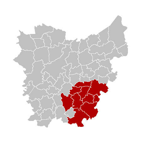
English: Map of the province East Flanders, showing Aalst arrondissement in red.
Français : Carte indiquant la localisation de l'arrondissement de Alost (en rouge) dans la province de Flandre-Orientale.
Nederlands: Kaart van de provincie Oost-Vlaanderen met het arrondissement Aalst in het in het rood. |
| Source | Own work |
| Author | LennartBolks, colours by Drieskamp. |
Licensing[edit]
| I, the copyright holder of this work, release this work into the public domain. This applies worldwide. In some countries this may not be legally possible; if so: I grant anyone the right to use this work for any purpose, without any conditions, unless such conditions are required by law. |
File history
Click on a date/time to view the file as it appeared at that time.
| Date/Time | Thumbnail | Dimensions | User | Comment | |
|---|---|---|---|---|---|
| current | 09:14, 27 April 2021 | | 456 × 462 (6 KB) | Floris DC (talk | contribs) | Betere kwaliteit. |
| 15:27, 8 February 2019 |  | 270 × 203 (2 KB) | NordNordWest (talk | contribs) | upd 2019 | |
| 21:02, 10 March 2006 |  | 270 × 203 (5 KB) | Wester (talk | contribs) |
You cannot overwrite this file.
File usage on Commons
The following page uses this file:
File usage on other wikis
The following other wikis use this file:
- Usage on bg.wikipedia.org
- Usage on br.wikipedia.org
- Usage on bs.wikipedia.org
- Usage on cs.wikipedia.org
- Usage on de.wikipedia.org
- Usage on en.wikipedia.org
- Usage on es.wikipedia.org
- Usage on eu.wikipedia.org
- Usage on fa.wikipedia.org
- Usage on frr.wikipedia.org
- Usage on hr.wikipedia.org
- Usage on hu.wikipedia.org
- Usage on it.wikipedia.org
- Usage on lb.wikipedia.org
- Usage on li.wikipedia.org
- Usage on lv.wikipedia.org
- Usage on nl.wikipedia.org
- Usage on no.wikipedia.org
- Usage on pt.wikipedia.org
- Usage on sh.wikipedia.org
- Usage on simple.wikipedia.org
- Usage on th.wikipedia.org
- Usage on vec.wikipedia.org
- Usage on vi.wikipedia.org
- Usage on vls.wikipedia.org