File:Bay-of-Piran maritime-boundary-dispute.jpg
Aller à la navigation
Aller à la recherche
Pas de plus haute résolution disponible.
Bay-of-Piran_maritime-boundary-dispute.jpg (709 × 600 pixels, taille du fichier : 160 kio, type MIME : image/jpeg)
Légendes
Légendes
Ajoutez en une ligne la description de ce que représente ce fichier
Description[modifier]

|
Une version vectorielle de cette image existe, dans le format « SVG ». Si elle n’est pas inférieure, elle devrait être utilisée à la place de la présente version pour des affichages en plus grandes dimensions ou nécessitant une meilleure résolution.
File:Bay-of-Piran maritime-boundary-dispute.jpg → File:Bay-of-Piran maritime-boundary-dispute.svg
Pour plus d’informations sur les images vectorielles, consultez la page de transition de Commons vers le format SVG. Voir aussi les informations à propos de la manière dont le logiciel MediaWiki gère les images au format SVG. |
 |
| Description |
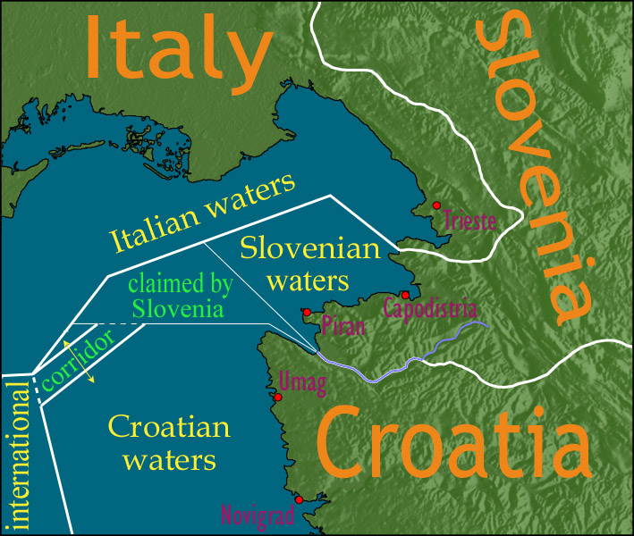
English: Map showing a diplomatic dispute resulting from Slovenia's desire to obtain a direct corridor from its own territorial waters to international waters, to avoid the necessity of Slovenian ships having to sail through the territorial waters of any other country to get to the high seas. Slovenia's only seacoast is in the Bay of Piran / Gulf of Trieste (as shown in this map), and its only commercial seaport is Capodistria / Koper (the eastern of the two red dots in Slovenia on this map), while Italy and Croatia both have long seacoasts outside the area shown in this map.
Slovenia's claim to the area labelled with green text, and the existence of a corridor to international waters, would have been allowed by Croatia under the Drnovšek-Račan agreement, but this was never ratified by either countries' parliaments. This is an English version of image de:Bild:Grenzstreit-Bucht-von-Piran.jpg, created using image Image:BorderDispute_BayOfPiran_blank.png. Raw Adobe Photoshop PSD files (with all text on different type layers) are available on request. |
| Date | |
| Source | File:BorderDispute_BayOfPiran_blank.png |
| Auteur |
|
| Autorisation (Réutilisation de ce fichier) |
The underlying source Image:BorderDispute_BayOfPiran_blank.png is declared to be GFDL, while I declare my changes to it to be PD. |
| Autres versions | Œuvres dérivées de ce fichier : Bay-of-Piran maritime-boundary-dispute.svg |

Conditions d’utilisation[modifier]

|
Vous avez la permission de copier, distribuer et modifier ce document selon les termes de la GNU Free Documentation License version 1.2 ou toute version ultérieure publiée par la Free Software Foundation, sans sections inaltérables, sans texte de première page de couverture et sans texte de dernière page de couverture. Un exemplaire de la licence est inclus dans la section intitulée GNU Free Documentation License. |
| Ce fichier est disponible selon les termes de la licence Creative Commons Attribution – Partage dans les Mêmes Conditions 3.0 (non transposée). | ||
| ||
| Ce bandeau de licence a été ajouté à ce fichier dans le cadre de la procédure de mise à jour des licences des images sous GFDL. |
Historique du fichier
Cliquer sur une date et heure pour voir le fichier tel qu'il était à ce moment-là.
| Date et heure | Vignette | Dimensions | Utilisateur | Commentaire | |
|---|---|---|---|---|---|
| actuel | 8 janvier 2007 à 14:17 | | 709 × 600 (160 kio) | AnonMoos (d | contributions) | adding city names |
| 24 décembre 2006 à 18:13 |  | 709 × 600 (156 kio) | AnonMoos (d | contributions) | deepening colors slightly | |
| 14 décembre 2006 à 14:00 |  | 709 × 600 (156 kio) | AnonMoos (d | contributions) | Map showing diplomatic dispute over Slovenia's desire to obtain a direct corridor from its own territorial waters to international waters, to avoid Slovenian ships having to sail through the territorial waters of any other country to get to the high seas. |
Vous ne pouvez pas remplacer ce fichier.
Utilisations locales du fichier
Les 16 pages suivantes utilisent ce fichier :
- Atlas of Croatia
- Atlas of Italy
- Atlas of Slovenia
- User:AnonMoos/Gallery (non-self)
- File:Bay-of-Piran maritime-boundary-dispute-ar.png
- File:Bay-of-Piran maritime-boundary-dispute-br.svg
- File:Bay-of-Piran maritime-boundary-dispute-eo.svg
- File:Bay-of-Piran maritime-boundary-dispute-fr.svg
- File:Bay-of-Piran maritime-boundary-dispute-hr.svg
- File:Bay-of-Piran maritime-boundary-dispute-hu.svg
- File:Bay-of-Piran maritime-boundary-dispute-it.SVG
- File:Bay-of-Piran maritime-boundary-dispute-mk.SVG
- File:Bay-of-Piran maritime-boundary-dispute-ru.svg
- File:Bay-of-Piran maritime-boundary-dispute-sr.svg
- File:Bay-of-Piran maritime-boundary-dispute.svg
- Template:Other versions/Bay-of-Piran maritime-boundary-dispute
Utilisations du fichier sur d’autres wikis
Les autres wikis suivants utilisent ce fichier :
- Utilisation sur de.wikipedia.org
- Utilisation sur en.wikipedia.org
- Utilisation sur en.wikinews.org
- Utilisation sur es.wikipedia.org
- Utilisation sur fy.wikipedia.org
- Utilisation sur it.wikipedia.org
- Utilisation sur ja.wikipedia.org
- Utilisation sur ko.wikipedia.org
- Utilisation sur pl.wikipedia.org
- Utilisation sur sl.wikipedia.org
- Utilisation sur zh.wikipedia.org