File:Beaufort Sea and disputed waters cropped.png
Aller à la navigation
Aller à la recherche
Pas de plus haute résolution disponible.
Beaufort_Sea_and_disputed_waters_cropped.png (509 × 456 pixels, taille du fichier : 122 kio, type MIME : image/png)
Légendes
Légendes
Ajoutez en une ligne la description de ce que représente ce fichier
| Description |
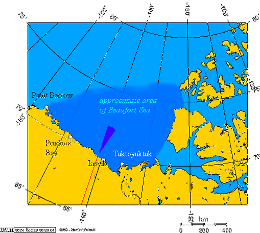
This is a cropped version of Image:Beaufort_Sea_and_disputed_waters.png. Español: Área aproximada del Mar de Beaufort, y el área en disputa
Beaufort Sea and the disputed waters The wedge shaped area on this map is the approximate area of the waters in dispute between the Yukon and Alaska. The longitude and latitudes of the communities follow:
|
||||||||||
| Source | Own work by uploader, using this online map creation tool | ||||||||||
| Auteur | Geo Swan | ||||||||||
| Autorisation (Réutilisation de ce fichier) |
|
||||||||||
| Autres versions | Image:Beaufort_Sea_and_disputed_waters.png |

Historique du fichier
Cliquer sur une date et heure pour voir le fichier tel qu'il était à ce moment-là.
| Date et heure | Vignette | Dimensions | Utilisateur | Commentaire | |
|---|---|---|---|---|---|
| actuel | 26 août 2007 à 17:11 | | 509 × 456 (122 kio) | Reaper X (d | contributions) | {{Information |Description='''This is a cropped version of Image:Beaufort_Sea_and_disputed_waters.png.''' {{es|Área aproximada del Mar de Beaufort, y el área en disputa}} Beaufort Sea and the disputed waters The wedge shaped area on this map is |
Vous ne pouvez pas remplacer ce fichier.
Utilisations locales du fichier
Aucune page n’utilise ce fichier.
Utilisations du fichier sur d’autres wikis
Les autres wikis suivants utilisent ce fichier :
- Utilisation sur fr.wikipedia.org