File:Cascadia earthquake sources.png
Aller à la navigation
Aller à la recherche
Pas de plus haute résolution disponible.
Cascadia_earthquake_sources.png (580 × 575 pixels, taille du fichier : 25 kio, type MIME : image/png)
Légendes
Légendes
Ajoutez en une ligne la description de ce que représente ce fichier
Description[modifier]
| Description |
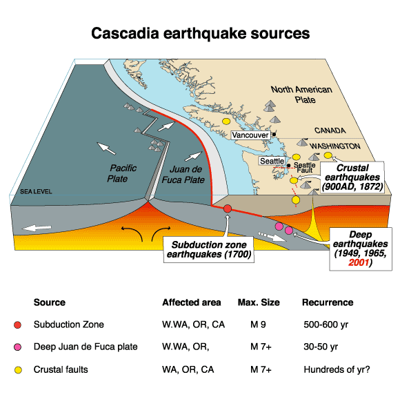
English: The Cascadia Earthquake. |
| Date | 18 juillet 2007 (date de téléversement originale) |
| Source | https://geomaps.wr.usgs.gov/pacnw/pacnweq/pdf/subd_eqpg.pdf |
| Auteur |
Original téléversé par Arg sur Wikipédia anglais.. Later versions were uploaded by Remember the dot at en.wikipedia. |
Conditions d’utilisation[modifier]
Cette image est placée dans le domaine public parce qu'elle contient des éléments issus de l'United States Geological Survey, une agence du Département de l'Intérieur des États-Unis. Pour plus d'information, consultez la politique officielle de copyright de l'USGS (en anglais)
|
Journal des téléversements d’origine[modifier]
La page de description originale était ici. Tous les noms d'utilisateur qui suivent se rapportent à en.wikipedia.
- 2007-07-18 20:41 Remember the dot 580×575×8 (26101 bytes) removed border and US government markings
- 2007-07-18 20:38 PNG crusade bot 582×577×8 (27100 bytes) == Summary == The Cascadia Earthquake To replace an inferior-quality jpeg version of this file in Cascadia_earthquake.jpeg {{PD-USGov-Interior-USGS}} Got from [http://wrgis.wr.usgs.gov/wgmt/pacnw/pacnweq/casceq.html], a US government site (note: page moved, new address is http://geomaps.wr.usgs.gov/pacnw/pacnweq/casceq.html). =
Automatically converted to PNG[modifier]
The PNG crusade bot automatically converted this image to the more efficient en:PNG format. The image was previously uploaded as "Cascadia earthquake.gif".
Previous file history[modifier]
- 15:32:18, 28 April 2007 (UTC) . . Arg (Talk | contribs) . . 582x577 (35,329 bytes) (The Cascadia Earthquake To replace an inferior-quality jpeg version of this file in Cascadia_earthquake.jpeg Got from [http://wrgis.wr.usgs.gov/wgmt/pacnw/pacnweq/casceq.html], a US government site. )
Previous description history[modifier]
- 18:04:58, 12 July 2007 (UTC) Remember the dot (Talk | contribs) (ShouldBePNG)
- 15:32:18, 28 April 2007 (UTC) Arg (Talk | contribs) (The Cascadia Earthquake To replace an inferior-quality jpeg version of this file in Cascadia_earthquake.jpeg Got from [http://wrgis.wr.usgs.gov/wgmt/pacnw/pacnweq/casceq.html], a US government site.)
Historique du fichier
Cliquer sur une date et heure pour voir le fichier tel qu'il était à ce moment-là.
| Date et heure | Vignette | Dimensions | Utilisateur | Commentaire | |
|---|---|---|---|---|---|
| actuel | 23 septembre 2007 à 16:24 | | 580 × 575 (25 kio) | TCY (d | contributions) | {{Information |Description=__NOTOC__ == Summary == The Cascadia Earthquake To replace an inferior-quality jpeg version of this file in Cascadia_earthquake.jpeg Got from [http://wrgis.wr.usgs.gov/wgmt/pacnw/pacnweq/casceq.html], a US government site. |
Vous ne pouvez pas remplacer ce fichier.
Utilisations locales du fichier
Les 2 pages suivantes utilisent ce fichier :
Utilisations du fichier sur d’autres wikis
Les autres wikis suivants utilisent ce fichier :
- Utilisation sur ar.wikipedia.org
- Utilisation sur ca.wikipedia.org
- Utilisation sur cs.wikipedia.org
- Utilisation sur de.wikipedia.org
- Utilisation sur en.wikipedia.org
- Utilisation sur en.wikibooks.org
- Utilisation sur fr.wikipedia.org
- Utilisation sur it.wikipedia.org
- Utilisation sur ja.wikipedia.org
- Utilisation sur ko.wikipedia.org
- Utilisation sur mk.wikipedia.org
- Utilisation sur uk.wikipedia.org
- Utilisation sur vi.wikipedia.org
- Utilisation sur zh.wikipedia.org
Catégories :
- Maps of Cascadia Subduction Zone
- Maps of subduction zones
- Block diagrams (cartography)
- Maps of earthquakes in North America
- Geography of British Columbia
- Geography of Washington (state)
- Volcanology of the United States
- Diagrams of the Cascade Range
- Geology of British Columbia
- Earthquakes in British Columbia
- Geology of Washington (state)
- Earthquakes in Washington (state)