File:Dakotatribesmap.jpg
Aller à la navigation
Aller à la recherche
Taille de cet aperçu : 800 × 583 pixels. Autres résolutions : 320 × 233 pixels | 640 × 466 pixels | 891 × 649 pixels.
Fichier d’origine (891 × 649 pixels, taille du fichier : 212 kio, type MIME : image/jpeg)
Légendes
Légendes
Ajoutez en une ligne la description de ce que représente ce fichier
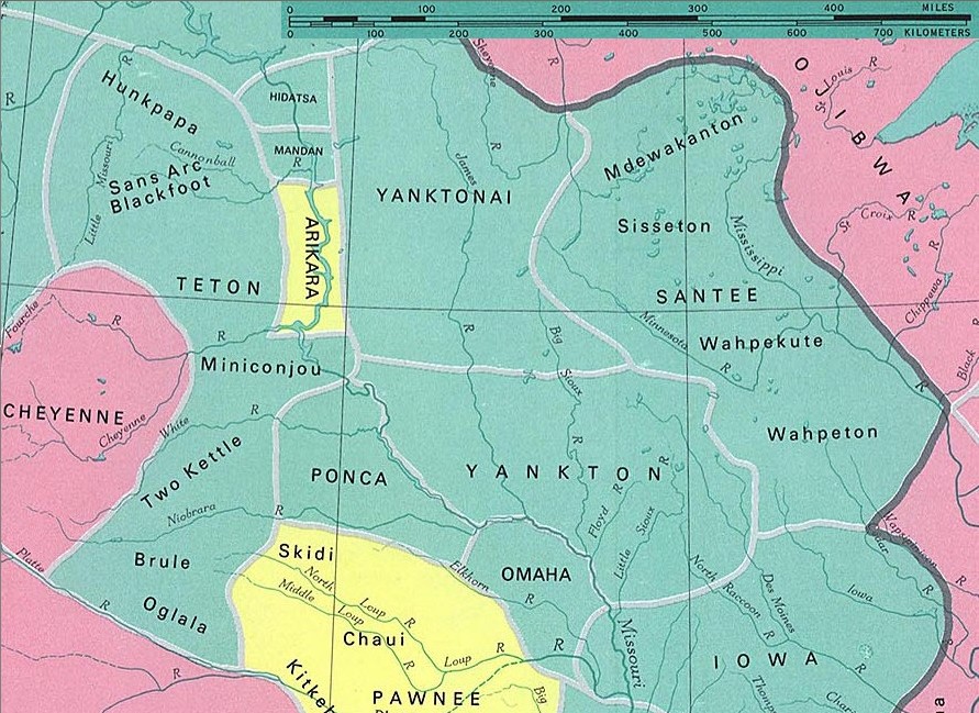
Territory of Sioux and neighboring tribes (capitals) and sub-tribes in the 1st half of the 19th century. The dark line separates cultural areas. Lang. groups: Sioux green (not all tribes belong to the Sioux nation), Algonkin pink and Caddian yellow
Dakota tribes
fragment from: http://www.lib.utexas.edu/maps/national_atlas_1970/ca000097.jpg
Most of the maps scanned by the University of Texas Libraries and served from this web site are in the public domain. No permissions are needed to copy them. You may download them and use them as you wish.
Ce fichier est dans le domaine public, parce que Most of the maps scanned by the University of Texas Libraries and served from this web site (www.lib.utexas.edu) are in the public domain. No permissions are needed to copy them. You may download them and use them as you wish.
Si cela n'est pas légalement possible : Veuillez vérifier que la raison donnée est compatible avec la politique de licences de Commons.
|
also see

Historique du fichier
Cliquer sur une date et heure pour voir le fichier tel qu'il était à ce moment-là.
| Date et heure | Vignette | Dimensions | Utilisateur | Commentaire | |
|---|---|---|---|---|---|
| actuel | 10 janvier 2006 à 23:37 | | 891 × 649 (212 kio) | Pitert (d | contributions) | Dakota tribes fragment from: http://www.lib.utexas.edu/maps/national_atlas_1970/ca000097.jpg {{PD}} |
Vous ne pouvez pas remplacer ce fichier.
Utilisations locales du fichier
La page suivante utilise ce fichier :
Utilisations du fichier sur d’autres wikis
Les autres wikis suivants utilisent ce fichier :
- Utilisation sur ca.wikipedia.org
- Utilisation sur cs.wikipedia.org
- Utilisation sur es.wikipedia.org
- Utilisation sur fi.wikipedia.org
- Utilisation sur fr.wikipedia.org
- Utilisation sur ja.wikipedia.org
- Utilisation sur pl.wikipedia.org