File:Docklands Light Railway.svg
Aller à la navigation
Aller à la recherche

Taille de cet aperçu PNG pour ce fichier SVG : 761 × 599 pixels. Autres résolutions : 305 × 240 pixels | 610 × 480 pixels | 975 × 768 pixels | 1 280 × 1 008 pixels | 2 560 × 2 016 pixels.
Fichier d’origine (Fichier SVG, nominalement de 800 × 630 pixels, taille : 32 kio)
Légendes
Légendes
Ajoutez en une ligne la description de ce que représente ce fichier
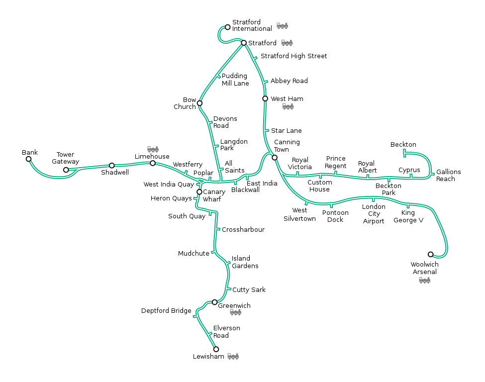
Generated as part of the London Underground geographic maps project by software written by ed g2s • talk and James D. Forrester utilising GPS data.
NB: Routes between stations are interpolated and may not be geographically accurate

|
Vous avez la permission de copier, distribuer et modifier ce document selon les termes de la GNU Free Documentation License version 1.2 ou toute version ultérieure publiée par la Free Software Foundation, sans sections inaltérables, sans texte de première page de couverture et sans texte de dernière page de couverture. Un exemplaire de la licence est inclus dans la section intitulée GNU Free Documentation License. |
| Ce fichier est disponible selon les termes de la licence Creative Commons Attribution – Partage dans les Mêmes Conditions 3.0 (non transposée). | ||
| ||
| Ce bandeau de licence a été ajouté à ce fichier dans le cadre de la procédure de mise à jour des licences des images sous GFDL. |
Ce fichier est sous licence Creative Commons Attribution – Partage dans les Mêmes Conditions 2.5 Générique, 2.0 Générique et 1.0 Générique.
- Vous êtes libre :
- de partager – de copier, distribuer et transmettre cette œuvre
- d’adapter – de modifier cette œuvre
- Sous les conditions suivantes :
- paternité – Vous devez donner les informations appropriées concernant l'auteur, fournir un lien vers la licence et indiquer si des modifications ont été faites. Vous pouvez faire cela par tout moyen raisonnable, mais en aucune façon suggérant que l’auteur vous soutient ou approuve l’utilisation que vous en faites.
- partage à l’identique – Si vous modifiez, transformez, ou vous basez sur cette œuvre, vous devez distribuer votre contribution sous la même licence ou une licence compatible avec celle de l’original.
Historique du fichier
Cliquer sur une date et heure pour voir le fichier tel qu'il était à ce moment-là.
| Date et heure | Vignette | Dimensions | Utilisateur | Commentaire | |
|---|---|---|---|---|---|
| actuel | 15 juillet 2019 à 09:32 | | 800 × 630 (32 kio) | Lasunncty (d | contributions) | restored All Saints pip, simplified SVG |
| 31 août 2011 à 14:31 |  | 800 × 630 (62 kio) | Mattbuck (d | contributions) | Reverted to version as of 01:32, 13 January 2009 - stratford link open | |
| 13 janvier 2009 à 01:33 |  | 800 × 630 (62 kio) | Dtcdthingy~commonswiki (d | contributions) | Version with Stratford International branch under construction | |
| 13 janvier 2009 à 01:32 |  | 800 × 630 (62 kio) | Dtcdthingy~commonswiki (d | contributions) | Version with Stratford International branch open (revert to this when line opens) | |
| 4 janvier 2009 à 14:01 |  | 800 × 580 (56 kio) | Dtcdthingy~commonswiki (d | contributions) | Marked Woolwich Arsenal as tail interchange, Tower Gateway as interchange | |
| 4 janvier 2009 à 13:52 |  | 800 × 580 (57 kio) | Dtcdthingy~commonswiki (d | contributions) | Added Woolwich Arsenal, relocated South Quay, removed "and London Arena", greatly improved geographical accuracy | |
| 16 décembre 2007 à 22:46 |  | 800 × 580 (50 kio) | IIVQ (d | contributions) | Langdon Park station added (manually) | |
| 8 décembre 2005 à 01:43 |  | 800 × 580 (49 kio) | Ed g2s (d | contributions) | new branch | |
| 10 septembre 2005 à 15:16 |  | 800 × 580 (38 kio) | Ed g2s (d | contributions) | {{London Underground geographic map|Docklands_Light_Railway}} |
Vous ne pouvez pas remplacer ce fichier.
Utilisations locales du fichier
Les 11 pages suivantes utilisent ce fichier :
- Docklands Light Railway
- Public transport in London
- User:Chumwa/OgreBot/Potential transport maps/2019 July 11-20
- User:Chumwa/OgreBot/Public transport information/2019 July 11-20
- User:Chumwa/OgreBot/Transport Maps/2019 July 11-20
- User:Chumwa/OgreBot/Travel and communication maps/2019 July 11-20
- User:Jdforrester
- User:Mattbuck/Railways/2019 July
- Category:Docklands Light Railway
- Category:Docklands Light Railway stations
- Category:Views from trains on the Docklands Light Railway
Utilisations du fichier sur d’autres wikis
Les autres wikis suivants utilisent ce fichier :
- Utilisation sur ar.wikipedia.org
- Utilisation sur bn.wikipedia.org
- Utilisation sur ca.wikipedia.org
- Utilisation sur cy.wikipedia.org
- Utilisation sur de.wikipedia.org
- Utilisation sur en.wikipedia.org
- Utilisation sur eo.wikipedia.org
- Utilisation sur es.wikipedia.org
- Utilisation sur eu.wikipedia.org
- Utilisation sur fa.wikipedia.org
- Utilisation sur fr.wikipedia.org
- Docklands Light Railway
- Cutty Sark (DLR)
- Shadwell (DLR)
- King George V (DLR)
- Beckton (DLR)
- Lewisham (DLR)
- Greenwich (DLR)
- Tower Gateway (DLR)
- Island Gardens (DLR)
- Pudding Mill Lane (DLR)
- Bow Church (DLR)
- Devons Road (DLR)
- Langdon Park (DLR)
- All Saints (DLR)
- Poplar (DLR)
- Blackwall (DLR)
- East India (DLR)
- Royal Victoria (DLR)
- Custom House (DLR)
- Royal Albert (DLR)
- Beckton Park (DLR)
- Cyprus (DLR)
- Gallions Reach (DLR)
- West Silvertown (DLR)
- Pontoon Dock (DLR)
- London City Airport (DLR)
- Woolwich Arsenal (DLR)
- Limehouse (DLR)
- Westferry (DLR)
- West India Quay (DLR)
- Heron Quays (DLR)
- South Quay (DLR)
- Crossharbour (DLR)
- Mudchute (DLR)
Voir davantage sur l’utilisation globale de ce fichier.