File:GandiolMap.jpg
Jump to navigation
Jump to search

Size of this preview: 227 × 599 pixels. Other resolutions: 91 × 240 pixels | 388 × 1,023 pixels.
Original file (388 × 1,023 pixels, file size: 96 KB, MIME type: image/jpeg)
Captions
Captions
Add a one-line explanation of what this file represents
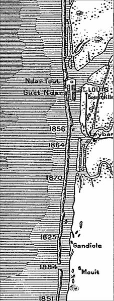
| Description | Carte des environs de Saint-Louis du Sénégal, in Elisée Reclus, Nouvelle géographie universelle : la terre et les hommes, tome XII, p. 191 |
| Date | between 1876 and 1894 |
| Source |
Cropped from Bibliothèque nationale de France |
| Author | unknown (gravure) |
| Previous public domain rationale, no longer applicable | ||
|---|---|---|
|
File history
Click on a date/time to view the file as it appeared at that time.
| Date/Time | Thumbnail | Dimensions | User | Comment | |
|---|---|---|---|---|---|
| current | 13:00, 25 March 2008 | 388 × 1,023 (96 KB) | Ji-Elle (talk | contribs) | {{Information |Description=Carte des environs de Saint-Louis du Sénégal, in Elisée Reclus, ''Nouvelle géographie universelle : la terre et les hommes'', tome XII, p. 191 |Source=Cropped from Gallica [http://gallica.bnf.fr/ark:/12148/bpt6k31519m] |Dat |
You cannot overwrite this file.
File usage on Commons
There are no pages that use this file.
File usage on other wikis
The following other wikis use this file: