File:Hurricane Fabian 02 sept 2003.jpg
Aller à la navigation
Aller à la recherche

Taille de cet aperçu : 458 × 599 pixels. Autres résolutions : 183 × 240 pixels | 367 × 480 pixels | 587 × 768 pixels | 783 × 1 024 pixels | 1 566 × 2 048 pixels | 5 200 × 6 800 pixels.
Fichier d’origine (5 200 × 6 800 pixels, taille du fichier : 5,19 Mio, type MIME : image/jpeg)
Légendes
Légendes
Ajoutez en une ligne la description de ce que représente ce fichier
Description
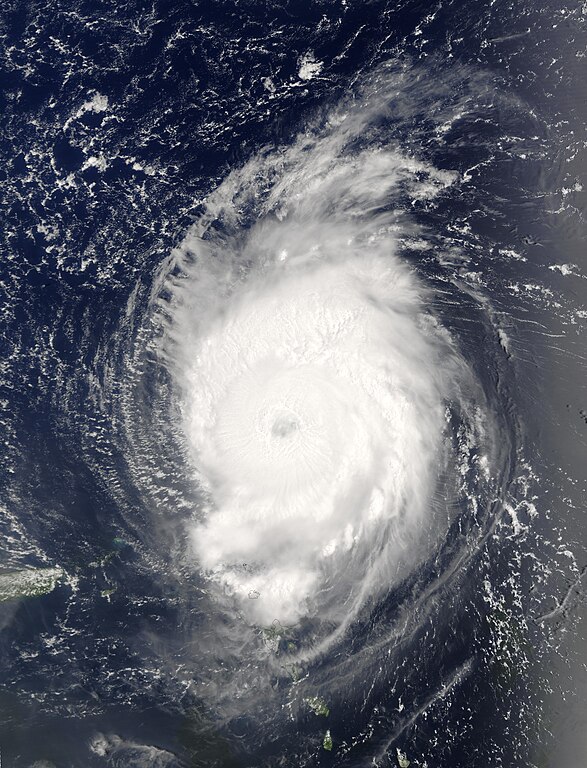
[modifier]| Description | The MODIS instrument onboard NASA's Terra spacecraft captured this bird's-eye view of Hurricane Fabian in the Atlantic Ocean. In this image Fabian is located about 190 miles north-northeast of Barbuda in the northern Leeward Islands. Fabian is a Category 4 storm on the Saffir-Simpson Scale and is packing sustained winds of 140 mph with higher gusts. The National Hurricane Center expects Fabian to continue on a west-northwest path at 10 mph for the next 24 hours. | |||||
| Date | ||||||
| Source | http://visibleearth.nasa.gov/view_rec.php?id=5736 | |||||
| Auteur | Jacques Descloitres, MODIS Rapid Response Team, NASA/GSFC | |||||
| Autorisation (Réutilisation de ce fichier) |
|
|||||
| Autres versions | Image:Hurricane fabian 2003.jpg |

Historique du fichier
Cliquer sur une date et heure pour voir le fichier tel qu'il était à ce moment-là.
| Date et heure | Vignette | Dimensions | Utilisateur | Commentaire | |
|---|---|---|---|---|---|
| actuel | 29 septembre 2006 à 15:45 | | 5 200 × 6 800 (5,19 Mio) | Good kitty (d | contributions) | == Summary == {{Information |Description=The MODIS instrument onboard NASA's Terra spacecraft captured this bird's-eye view of Hurricane Fabian in the Atlantic Ocean. In this image Fabian is located about 190 miles north-northeast of Barbuda in the northe |
Vous ne pouvez pas remplacer ce fichier.
Utilisations locales du fichier
Les 2 pages suivantes utilisent ce fichier :
Utilisations du fichier sur d’autres wikis
Les autres wikis suivants utilisent ce fichier :
- Utilisation sur ca.wikipedia.org
- Utilisation sur en.wikipedia.org
- Utilisation sur eo.wikipedia.org
- Utilisation sur fr.wikipedia.org
- Utilisation sur simple.wikipedia.org
- Utilisation sur tl.wikipedia.org
- Utilisation sur www.wikidata.org
- Utilisation sur zh.wikipedia.org