File:Madhya Pradesh in India.png
Madhya_Pradesh_in_India.png (350 × 426 pixels, taille du fichier : 76 kio, type MIME : image/png)
Légendes
Légendes

|
Cette image (de type locator map) devrait être recréée dans un format vectoriel, en tant que fichier SVG. Cela offrirait plusieurs avantages : voir Commons:Media for cleanup pour plus d'informations. Si une version SVG de cette image est déjà disponible, merci de bien vouloir l'envoyer. Après cela, remplacez ce modèle par {{vector version available|nouveau nom d'image.svg}}.
|
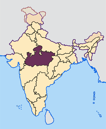
--- Map made by me, Nichalp --- Note: The Indian state of w:Jammu and Kashmir is claimed by w:India, w:Pakistan and the w:People's Republic of China. This map depicts the boundaries of the state as it was in 1947. Areas administered by India is coloured as per the rest of the states, and the area administered by Pakistan and China are coloured in a neutral colour. See the map of Jammu and Kashmir.
The Indian state of w:Arunachal Pradesh is claimed by China as a part of w:South Tibet. The claimed region is depicted in a pale shade of pink. See the map of Arunachal Pradesh.
The Indian territorial waters extend to a distance of twelve nautical miles.

|
Vous avez la permission de copier, distribuer et modifier ce document selon les termes de la GNU Free Documentation License version 1.2 ou toute version ultérieure publiée par la Free Software Foundation, sans sections inaltérables, sans texte de première page de couverture et sans texte de dernière page de couverture. Un exemplaire de la licence est inclus dans la section intitulée GNU Free Documentation License. |
| Ce fichier est disponible selon les termes de la licence Creative Commons Attribution – Partage dans les Mêmes Conditions 3.0 (non transposée). | ||
| ||
| Ce bandeau de licence a été ajouté à ce fichier dans le cadre de la procédure de mise à jour des licences des images sous GFDL. |
Historique du fichier
Cliquer sur une date et heure pour voir le fichier tel qu'il était à ce moment-là.
| Date et heure | Vignette | Dimensions | Utilisateur | Commentaire | |
|---|---|---|---|---|---|
| actuel | 23 avril 2005 à 07:30 | | 350 × 426 (76 kio) | Nichalp (d | contributions) | NPOV map |
| 23 avril 2005 à 07:21 |  | 200 × 231 (22 kio) | Kerpal (d | contributions) | Reverted to earlier revision | |
| 23 avril 2005 à 06:23 |  | 500 × 608 (121 kio) | Nichalp (d | contributions) | Reverted to earlier revision | |
| 23 avril 2005 à 05:00 |  | 200 × 231 (22 kio) | Kerpal (d | contributions) | Reverted to earlier revision | |
| 23 avril 2005 à 04:54 |  | 500 × 608 (121 kio) | Nichalp (d | contributions) | Reverted to earlier revision | |
| 22 avril 2005 à 21:05 |  | 200 × 231 (22 kio) | Kerpal (d | contributions) | Reverted to earlier revision | |
| 22 avril 2005 à 13:39 |  | 500 × 608 (121 kio) | Nichalp (d | contributions) | Reverted to earlier revision | |
| 22 avril 2005 à 09:48 |  | 200 × 231 (22 kio) | Kerpal (d | contributions) | originally by en:User:Morwen | |
| 21 avril 2005 à 18:00 |  | 500 × 608 (121 kio) | Nichalp (d | contributions) | --- Map made by me, ~~~ --- Note: The Indian state of w:Jammu and Kashmir is claimed by w:India, w:Pakistan and the w:People's Republic of China. This map depicts the boundaries of the state as it was in 1947. Areas administered by India |
Vous ne pouvez pas remplacer ce fichier.
Utilisations locales du fichier
Les 2 pages suivantes utilisent ce fichier :
- Top 200 locator map images that should use vector graphics
- File:IndiaMadhyaPradesh.png (redirection de fichier)
Utilisations du fichier sur d’autres wikis
Les autres wikis suivants utilisent ce fichier :
- Utilisation sur br.wikipedia.org
- Utilisation sur bxr.wikipedia.org
- Utilisation sur en.wikipedia.org
- User:Tanul
- Template:User Madhya Pradesh
- Jai Prakash Yadav (cricketer)
- User:Suyash
- User:Tanul/Userboxes
- User:Siddhant
- Dharampuri
- User:Chintu rohit
- 2004 Indian general election in Madhya Pradesh
- Wikipedia:WikiProject Madhya Pradesh
- Raja Hindu Rao
- User:!dea4u
- 2009 Indian general election in Madhya Pradesh
- Bindeshwari Goyal
- User:Gaurav713
- Template:MadhyaPradesh-stub
- Category:Madhya Pradeshi Wikipedians
- User:Abhinay.leo
- Template:User Madhya Pradesh/doc1
- User:Shobhit Gosain
- 2013 elections in India
- User:!dea4u/userboxes
- User:Suyash.dwivedi
- Bhima Kheda
- Nikhil Thakur
- User:Dr.Rohit Bhamoura
- Mukhya Mantri Yuva Swarozgar Yojana
- User:Brandybradham
- User:Har$h/sandbox
- User:Jaywardhan009
- List of speakers of the Madhya Pradesh Legislative Assembly
- User:Brandybradham/testcases
- User:Shreya.Bhopal
- User:Swapnil.Karambelkar
- User:Siddharth.Mishra
- User:Vijay Tiwari09
- User:Kiran.Dwivedi
- Newton Chikli Colliery disaster
- Nagjhiri
- Dewas Gate Inter State Bus Stand
- 2014 Indian general election in Madhya Pradesh
- Bicholi Hapsi
- Raigaon Assembly constituency
- Semariya Assembly constituency
- Mangawan Assembly constituency
- Manpur Assembly constituency
- Panagar Assembly constituency
- Sihora Assembly constituency
Voir davantage sur l’utilisation globale de ce fichier.